Situation Summary
Lebanon faces a sharp escalation in cross-border military activity and internal security fragmentation, with Israeli strikes, Hezbollah operations, and Lebanese army deployments creating a volatile, overlapping threat environment across southern and eastern governorates. Over the past 48 hours, coordinated Israeli airstrikes, drone operations, and ground-level confrontations have intensified in Nabatieh and South Lebanon, while explosive incidents targeting Lebanese military assets signal either Hezbollah repositioning or third-party escalation. The security picture is characterized by unpredictable civilian exposure, restricted movement corridors, and competing military actors operating in close proximity.
Key Developments
- Al-Mansouri, South Lebanon (July 18, 2026): A Lebanese army vehicle struck an explosive device, killing one soldier and wounding two others. Israeli military assessed the device was planted by Hezbollah rather than Israeli forces, indicating active IED campaigns by non-state actors in the operational zone.
- Tebnit, Nabatieh Governorate (July 18, 2026): Israeli military conducted a targeted strike on a Hezbollah cell following detection of a Hezbollah drone operation. The incident reflects active drone reconnaissance and kinetic response cycles in southern Lebanon.
- Harees, South Lebanon (night of July 17–18, 2026): Israeli forces opened machine-gun fire on the town, trapping residents and prompting appeals to the Lebanese army for evacuation. The incident highlights direct civilian exposure to cross-border fire.
- Kfar Rumman, Nabatieh district (July 17, 2026): An Israeli drone strike killed a motorcyclist and wounded others in the area. Israeli military reported conducting over 20 attacks across Lebanon in the past week in response to stated Hezbollah ceasefire violations.
- Multi-locality airstrikes and artillery (July 17–18, 2026): Concentrated Israeli airstrikes, artillery barrages, and controlled demolitions reported across Nabatieh and Bint Jbeil districts, assessed as a coordinated campaign rather than isolated clashes. Machine-gun fire on civilian areas and drone operations contributed to widespread movement restrictions.
- Lebanese Army Deployments (mid-July, ongoing): The Lebanese army has intensified checkpoint and presence operations around agreed pilot zones in southern Lebanon as part of US-mediated arrangements, affecting movement on key corridors linking the south, Beqaa, and Beirut.
Highest-Risk Areas
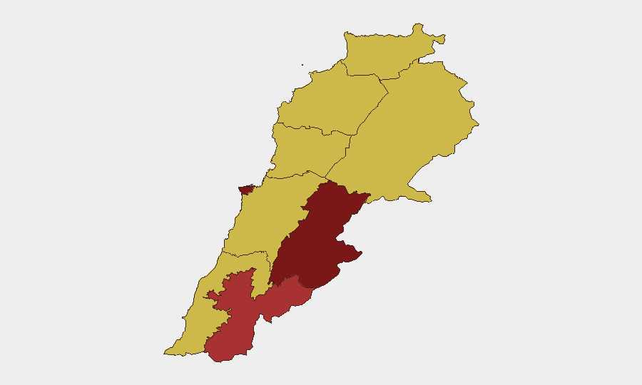
Beqaa Governorate (97.5) and Beirut Governorate (91) dominate the sub-national ranking, reflecting both direct military activity in the south and cascading instability affecting the capital's supply lines, displaced populations, and political volatility. Nabatieh Governorate (79.8) has emerged as the acute flashpoint over the past 48 hours, with overlapping Israeli strikes, Hezbollah operations, and Lebanese army movements creating compounded civilian and operational risk. South Governorate (67.5) remains under sustained pressure from cross-border fire and IED activity. Risk in Mount Lebanon and northern governorates (68–68.3) is elevated due to proximity to Beqaa and downstream pressure from southern displacement.
How GeoBit Would Assist
AOI Monitoring & Early Warning with persistent geofencing around high-risk zones (Nabatieh, Al-Mansouri, Tebnit) would enable duty-of-care teams to detect strike patterns and movement restrictions in real time. Conflict & Military capabilities — including force-structure tracking and weapons-capability analysis — provide context on Israeli and Hezbollah operational tempo and coordination. Routing & Network Analysis supports secure alternative route planning for personnel and asset movement, critical given dynamic checkpoint and fire-exposure patterns.
7-Day Outlook
Israeli strikes are likely to continue in response to Hezbollah activities, with Nabatieh and South Governorate remaining under sustained pressure. Civilian exposure remains high; movement restrictions will likely persist or expand. US-mediated ceasefire mechanics appear under stress, and further coordinated escalation (airstrikes + ground operations + IED activity) cannot be ruled out in the 7-day window.
Highest-Risk Areas — Ranked
| # | State / Region | Risk |
|---|---|---|
| 1 | Beqaa Governorate | 97.5 |
| 2 | Beirut Governorate | 91 |
| 3 | Nabatieh Governorate | 79.8 |
| 4 | Mount Lebanon Governorate | 68.3 |
| 5 | Keserwan-Jbeil Governorate | 68 |
| 6 | North Governorate | 67.5 |
| 7 | Akkar Governorate | 67.5 |
| 8 | South Governorate | 67.5 |
| 9 | Baalbek-Hermel Governorate | 67.5 |
Sources
Previous Daily Briefs
A new Lebanon brief is written every day — each with its own risk map and downloadable CSV. Here's the last week; use the calendar to go further back.
📅 Browse every day by calendar →
Highlighted days have a brief. Tap a day for that day's map & analysis, or “csv” for that day's dataset ($5).
Atlas — our AI intelligence desk — emails them this snapshot personally. Nothing else, no list.