Situation Summary
Mexico remains the third-highest-threat country globally (composite score 100; 802 tracked events), with security conditions volatile across cartel-affected and transit-corridor states. Recent signal activity reflects ongoing army investigations, parliamentary arrests, and corporate-sector threats dated July 14–16, though granular incident-level confirmation for the past 24–48 hours remains limited in open-source reporting. The security environment is characterized by concurrent cartel operations, civil unrest, and enforcement actions, creating compounded risks for personnel and assets across multiple regions.
Key Developments
- Army investigations ongoing (2026-07-16): Multiple military investigative actions flagged in signal data; specific operational scope and geography not confirmed in available reporting.
- Corporate-sector threats registered (2026-07-16): Companies operating in Mexico have been subject to explicit threat communications; sector and location not specified in current intelligence.
- Parliamentary detention activity (2026-07-14): Senate-linked arrests recorded; details on charges and individuals remain unclear.
- Mexican government enforcement escalation (2026-07-15): Authorities conducted arrests across unspecified locations; conditions and charges not yet detailed in cross-verified sources.
- Ongoing security operations: Indian Embassy advisory (current month) confirms active law-enforcement operations and road blockages across multiple regions, with directed public advisory to shelter in place and avoid enforcement zones—indicator of widespread operational tempo rather than discrete incident.
Note: Open-source and social-media verification for July 14–16, 2026 incident-level detail remains incomplete. Signal data confirms elevated activity; specific locations, casualties, and operational scope require additional corroboration from field sources or classified channels.
Highest-Risk Areas
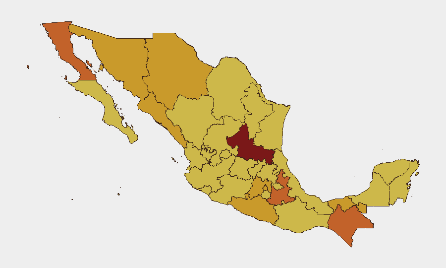
San Luis Potosí leads all Mexican states at risk score 100, followed by a tier of six states (Baja California, Puebla, Chiapas, Chihuahua, Tabasco, Sonora) at 72–75. These regions are driven by active cartel territorial control, enforcement operations, and trafficking-route competition; Chiapas and southern border zones add migration and civil-unrest dimensions. Mexico City and State of Mexico, despite urban infrastructure, rank 9th and 10th due to organized-crime presence and administrative-sector volatility. Corporate and expatriate personnel in the top-five states face elevated risk from direct cartel activity, civil disturbance, and collateral enforcement action; travel, supply-chain continuity, and facility security require elevated due-diligence protocols.
How GeoBit Would Assist
Security teams should employ AOI Monitoring & Early Warning on high-risk state capitals and corporate facilities to detect operational activity and movement patterns before incidents escalate. Intel Sweep and multi-language OSINT fusion (X/Twitter, Telegram, local media) enable real-time corroboration of government announcements, cartel communications, and enforcement actions to distinguish credible threats from rumors. Routing & Network Analysis supports dynamic journey planning for personnel transiting San Luis Potosí, Chiapas, and Sinaloa by identifying current blockades, cartel checkpoints, and safe corridors; satellite and GIS analysis tracks infrastructure disruption and force positioning near company assets.
7-Day Outlook
Parliamentary and enforcement activity suggests heightened government operations through mid-to-late July, likely concentrating on cartel-linked detention and asset seizure; collateral disruption to commerce and movement should be anticipated. Cartel response to enforcement typically manifests within 48–72 hours of high-profile arrests; elevated alert status for transportation corridors and border zones is warranted. Absence of de-escalation signals indicates sustained operational tempo through at least late July; personnel security protocols and supply-chain redundancy should remain at elevated posture.
Highest-Risk Areas — Ranked
| # | State / Region | Risk |
|---|---|---|
| 1 | San Luis Potosí | 100 |
| 2 | Baja California | 74.9 |
| 3 | Puebla | 74.9 |
| 4 | Chiapas | 73.6 |
| 5 | Chihuahua | 72.5 |
| 6 | Tabasco | 72.1 |
| 7 | Sonora | 72 |
| 8 | Sinaloa | 71.9 |
| 9 | Mexico City | 71.7 |
| 10 | State of Mexico | 71.5 |
| 11 | Guerrero | 71 |
| 12 | Coahuila | 70.8 |
Sources
Previous Daily Briefs
A new Mexico brief is written every day — each with its own risk map and downloadable CSV. Here's the last week; use the calendar to go further back.
📅 Browse every day by calendar →
Highlighted days have a brief. Tap a day for that day's map & analysis, or “csv” for that day's dataset ($5).
Atlas — our AI intelligence desk — emails them this snapshot personally. Nothing else, no list.