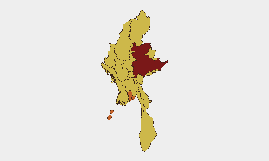
Situation Summary
Myanmar's composite threat score of 91 reflects sustained multi-front conflict involving the military junta, armed resistance groups, and ethnic armed organizations (EAOs), with no indication of de-escalation. The last 48 hours show escalating air operations in Rakhine State, intensified security sweeps in Yangon, and significant new displacement in eastern Kayah State, establishing a pattern of simultaneous pressure across conflict and urban control zones. Shan State remains the highest sub-national risk driver (93.6), while Yangon (73.6) presents acute urban security threats. The security environment is deteriorating, not stabilizing.
Key Developments
- Maungdaw Township, Rakhine State (2–3 July): Myanmar Air Force conducted fresh jet and helicopter strikes targeting Arakan Army positions near the Bangladesh border, with residents reporting panic in communities along the Naf River. Road access between Maungdaw and Buthidaung has been disrupted; multiple settlements reported destroyed or newly isolated.
- Cross-border impact, Teknaf/Cox's Bazar (2–3 July): Explosions and aircraft from the Rakhine airstrikes were audible and visible from the Bangladeshi side, prompting temporary movement restrictions and elevated anxiety among riverside communities on both sides of the frontier.
- Hlaing Tharyar Township, Yangon (night of 1–2 July): Intensified junta nighttime raids and checkpoint operations targeting suspected resistance cells, featuring door-to-door searches, arbitrary detentions, and expanded security cordons in industrial zones and key junctions.
- North Dagon Township, Yangon (night of 1–2 July): Parallel security sweeps conducted during the same 24–48-hour period; increased stop-and-search operations at roadblocks with detention of individuals accused of supporting anti-junta activities.
- Eastern Kayah State displacement (last 48 hours): Approximately 100,000 people newly or repeatedly displaced following reported indiscriminate attacks by security forces in the Loikaw–Demoso area; ongoing shelling and ground assaults in rural zones driving immediate civilian flight.
- Kachin, Mandalay, and Sagaing Regions (late June–2 July, ongoing): Continued armed clashes, ambushes, and junta ground operations along key transport routes; no lull in the past 48 hours; very high travel risk sustained across these areas.
Highest-Risk Areas
Shan State's leading risk score (93.6) reflects its status as a major battleground between the junta, resistance forces, and multiple EAOs, compounded by porous borders and limited state control. Yangon (73.6), while substantially lower, presents acute and immediate urban security risks—the past 48 hours of coordinated security sweeps indicate the junta is tightening control in the capital and targeting suspected opposition networks with increasing intensity. The remaining ten regions cluster at 63.6, indicating widespread but differentiated secondary and tertiary conflict zones; Rakhine's fresh airstrikes and Kayah's mass displacement elevate those regions' practical threat to personnel and supply chains despite the numerical ranking.
How GeoBit Would Assist
Teams with personnel or assets in Myanmar should employ AOI Monitoring & Early Warning on high-risk townships (Maungdaw, Hlaing Tharyar, Loikaw) for real-time alert on airstrikes, security sweeps, and displacement events. Routing & Network Analysis capability enables identification of alternative transport corridors and safe passage windows as roads between Maungdaw and Buthidaung and other trade routes become disrupted. Conflict & Military mapping and multi-language OSINT (X/Twitter, Telegram, YouTube) provide continuous situational updates on junta operations and EAO activity, feeding duty-of-care protocols and evacuation decision-making.
7-Day Outlook
Air operations in Rakhine are likely to persist or intensify as the junta consolidates control against the Arakan Army. Urban security operations in Yangon will remain elevated through the week, with increased checkpoints, curfews, and detention risk for individuals with perceived opposition ties. Displacement from conflict zones will continue; cross-border spillover into Bangladesh may provoke diplomatic friction and further complicate humanitarian access.
Highest-Risk Areas — Ranked
| # | State / Region | Risk |
|---|---|---|
| 1 | Shan State | 93.6 |
| 2 | Yangon | 73.6 |
| 3 | Tanintharyi Region | 63.6 |
| 4 | Chin | 63.6 |
| 5 | Sagaing Region | 63.6 |
| 6 | Kachin State | 63.6 |
| 7 | Wa State (Northern Region) | 63.6 |
| 8 | Magway | 63.6 |
| 9 | Mandalay | 63.6 |
| 10 | Rakhine | 63.6 |
| 11 | Ayeyarwady | 63.6 |
| 12 | Naypyitaw Union Territory | 63.6 |
Sources
Previous Daily Briefs
A new Myanmar brief is written every day — each with its own risk map and downloadable CSV. Here's the last week; use the calendar to go further back.
📅 Browse every day by calendar →
Highlighted days have a brief. Tap a day for that day's map & analysis, or “csv” for that day's dataset ($5).