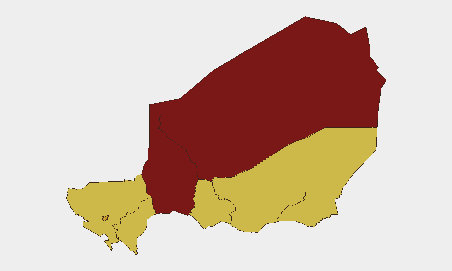
Situation Summary
Niger maintains a composite threat score of 100 (global rank #10), driven by persistent multi-actor conflict, civil unrest, and governance volatility across northern and central regions. Recent signal activity (7 tracked events) indicates heightened police and operative detention actions alongside journalist arrests and public statements from government entities on 2026-07-07 and 2026-07-09. The security environment remains fragmented by sub-national risk variation, with Tahoua and Agadez regions significantly outpacing the capital in threat severity.
Key Developments
Data Integrity Note: Open-source verification for Niger-specific developments in the last 24–48 hours is severely limited. Live web research (last 24h) returned primarily Nigeria-focused content and content older than 48 hours. The following platform signals were recorded but lack independent corroboration from multiple recent sources:
- 2026-07-09 · Police and operative detention actions — Two arrest/detain events involving police and operatives recorded; specific locations and causes unconfirmed.
- 2026-07-09 · Journalist arrests — Two separate journalist detention events flagged; geographic and circumstantial details unavailable from current open sources.
- 2026-07-07 · Government public statements and blockade action — Government entities issued public statements; a blockade event flagged without verified location or scope.
- Cross-border signal (Nigeria) — Territory occupation event attributed to Nigeria recorded; implications for Niger border security require clarification.
Assessment: Confirmation of the above events through independent, recent sources has not been achieved. Duty-of-care teams should treat these signals as preliminary indicators requiring immediate verification through in-country networks, diplomatic channels, or commercial OSINT before operational decision-making.
Highest-Risk Areas
Tahoua Region (risk 100) and Agadez Region (95.7) present the most acute threat environment, driven by sustained militant activity, trafficking networks, and limited state capacity. Niamey (72.1), despite lower absolute risk, concentrates civil unrest and political volatility affecting governance and international operations. Zinder, Diffa, and Tillabéri regions (all 70) represent a secondary tier of concern, with Diffa particularly exposed to cross-border jihadist activity from Nigeria and Chad. Risk differentiation suggests security protocols should be substantially more restrictive in the north and east than in southern or western zones.
How GeoBit Would Assist
Security teams operating in Niger should deploy AOI Monitoring & Early Warning with persistent watch over Tahoua, Agadez, and Diffa to capture real-time signal activity before escalation. Multi-language OSINT (social media, Telegram, radio SIGINT) targeting local and Francophone sources would improve detection of civil unrest and political announcements ahead of public disclosure. Routing & Network Analysis supports contingency planning and alternative transit corridors in high-risk regions, while conflict and actor mapping clarifies which armed groups and state entities are active in specific zones to inform access and liaison decisions.
7-Day Outlook
Detention activity and government statements suggest heightened political tension or security operations underway; the trajectory over the next 7 days will depend on whether these actions signal a broader crackdown or a localized response. Northern regions (Tahoua, Agadez) will likely remain elevated due to structural insurgent and criminal activity unrelated to near-term political shifts. Duty-of-care teams should maintain heightened situational awareness and prepare contingency protocols; open-source verification of current events remains a critical gap.
Highest-Risk Areas — Ranked
| # | State / Region | Risk |
|---|---|---|
| 1 | Tahoua Region | 100 |
| 2 | Agadez Region | 95.7 |
| 3 | Niamey | 72.1 |
| 4 | Zinder Region | 70 |
| 5 | Diffa Region | 70 |
| 6 | Tillabéri Region | 70 |
| 7 | Dosso Region | 70 |
| 8 | Maradi Region | 70 |
Sources
Previous Daily Briefs
A new Niger brief is written every day — each with its own risk map and downloadable CSV. Here's the last week; use the calendar to go further back.
📅 Browse every day by calendar →
Highlighted days have a brief. Tap a day for that day's map & analysis, or “csv” for that day's dataset ($5).
Atlas — our AI intelligence desk — emails them this snapshot personally. Nothing else, no list.