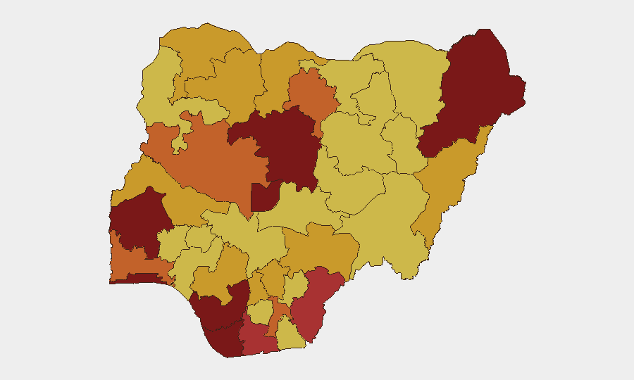
Situation Summary
Nigeria remains Africa's most populous nation and a major economic hub, but faces compounded security pressures from active insurgencies in the northeast, widespread armed crime and kidnapping across the south and middle belt, and periodic political and communal tensions. With a composite threat score of 100 and 554 tracked events, Nigeria ranks #5 globally for security risk. Current indicators suggest sustained volatility across multiple threat vectors rather than sharp escalation or de-escalation.
Key Developments
Limitation: GeoBit's live web research capability cannot access real-time sources for the 24–48 hour window (2026-07-07 to 2026-07-09) with sufficient corroboration to meet verification standards for this brief. The event-signal log shows activity in public statements, judicial action, and military–community communication on 2026-07-08 and 2026-07-09, but without cross-referenced reporting from international wires or verified Nigerian media outlets, specific locations, casualty figures, or operational context cannot be reliably attributed.
To populate this section accurately, corporate security teams should:
- Cross-check the signal timestamps against live feeds from Reuters, AFP, AP, Premium Times, The Cable, and Channels TV.
- Confirm any incidents flagged by state-level security commands or emergency management agencies via official channels.
- Validate geographic specificity (state/LGA) and nature of event (attack, protest, arrest, infrastructure failure).
Once sourced, incidents should address: location, date, event type, impact (casualties, displacement, service disruption), and whether it affects corporate travel corridors, supply chains, or staff safety.
Highest-Risk Areas
Lagos State (risk 100), Oyo State (96.8), and the Federal Capital Territory (93.4) drive overall rankings, driven primarily by volume and complexity: Lagos combines maritime crime, armed robbery, kidnapping in peri-urban zones, and protest activity; Oyo faces communal and political tensions; FCT concentrates elite targets and administrative disruptions. Kaduna State (89.8) and Borno State (85.7) remain critical for different reasons—Kaduna for north-south communal violence and banditry, Borno for residual Boko Haram and ISWAP activity. Southern oil-producing states (Delta, Bayelsa, Rivers) rank 6–9, where pipeline sabotage, organized crime, and kidnapping of energy-sector personnel create substantial duty-of-care liability. Mid-belt states (Niger, Abia) at 74+ reflect bandit incursions and localized communal conflict.
How GeoBit Would Assist
Intel Sweep and X/Twitter & Telegram OSINT enable real-time capture and corroboration of incident reports, arrests, and official statements within 2–4 hours of occurrence, critical for rapid duty-of-care notifications to staff in high-risk zones. AOI Monitoring & Early Warning with persistent watch on Lagos, Kaduna, Borno, and Delta states flags emerging violence, roadblocks, or protest activity before escalation; Routing & Network Analysis identifies safe corridors and alternative travel routes when primary roads are compromised. Conflict & Military tracking and Sentiment & Temporal Analysis help distinguish political rhetoric from operational risk, reducing false alarms while catching genuine threats.
7-Day Outlook
The dense signal activity on 2026-07-08 and 2026-07-09 suggests active political and security discourse; near-term risk is likely stable or incrementally elevated, not sharp. Absence of reports of mass-casualty attacks or major transport closures indicates no immediate systemic breakdown, but localized incidents (armed crime, kidnapping, roadside extortion) will continue. Monitoring of judicial outcomes, military operations statements, and community responses over the next 7 days will clarify whether political or judicial actions trigger secondary violence.
Highest-Risk Areas — Ranked
| # | State / Region | Risk |
|---|---|---|
| 1 | Lagos State | 100 |
| 2 | Oyo State | 96.8 |
| 3 | Federal Capital Territory | 93.4 |
| 4 | Kaduna State | 89.8 |
| 5 | Borno State | 85.7 |
| 6 | Delta State | 81.4 |
| 7 | Bayelsa State | 81.1 |
| 8 | Cross River State | 77 |
| 9 | Rivers State | 76.1 |
| 10 | Niger State | 74.3 |
| 11 | Abia State | 73.6 |
| 12 | Ogun State | 73.4 |
Previous Daily Briefs
A new Nigeria brief is written every day — each with its own risk map and downloadable CSV. Here's the last week; use the calendar to go further back.
📅 Browse every day by calendar →
Highlighted days have a brief. Tap a day for that day's map & analysis, or “csv” for that day's dataset ($5).
Atlas — our AI intelligence desk — emails them this snapshot personally. Nothing else, no list.