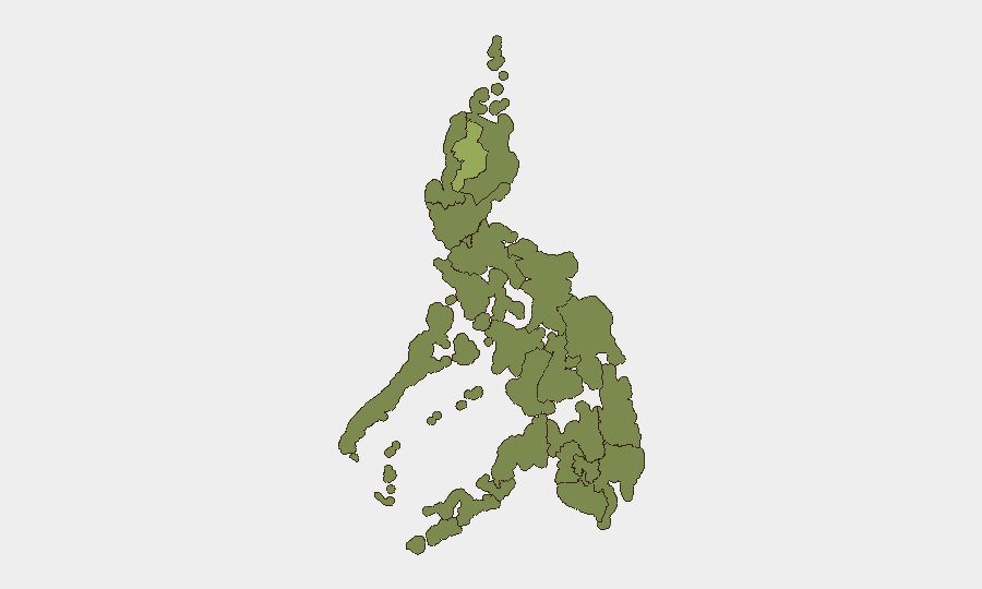
Situation Summary
The Philippines faces a mixed but concerning security environment as of 2 August 2026. While nationwide focus-crime incidents declined 30.43% in June, a cluster of improvised explosive device (IED) discoveries and a catastrophic building collapse in the past 72 hours signal elevated risk of targeted violence and infrastructure failure. Government security posture has been raised to maximum levels in Metro Manila ahead of and following President Marcos' State of the Nation Address, with law enforcement actively investigating potential links between recent IED incidents near critical state institutions.
Key Developments
- Building collapse, Angeles City, Pampanga (31 July–1 August, 2026): A structure under construction collapsed, killing at least 13 people with ongoing body recovery operations. Rescue efforts continue as of 1 August.
- IED blast at Department of Justice, Ermita, Manila (27 July, 2026, ongoing security response): An improvised explosive device detonated at the DOJ entrance at approximately 12:17 a.m., damaging a vehicle but causing no fatalities. The incident triggered intensified security sweeps and investigations across Metro Manila government zones.
- Suspected IED recovered near Senate, Diokno Boulevard, Pasay City (27 July, 2026, investigation active): Police discovered a device containing a 9V battery, blasting cap, clock, and brown powder on the center island near the Senate. PNP leadership has stated a "big possibility" the device is linked to the DOJ blast, elevating concern for related or copycat attacks.
- Maximum security activation for SONA and Metro Manila government districts (27 July–1 August, 2026): The Philippine National Police deployed significant forces along Commonwealth Avenue and around the Batasang Pambansa in response to the IED cluster. Security remains at the highest operational level as of 1 August.
- Suspected IED recovered in rural coconut farm, San Luis, Aurora (late July, 2026, investigation ongoing): Security forces safely neutralized a device discovered in Sitio Camalatan 1, Barangay Nonong. Investigation into possible insurgent or criminal activity continues, affecting local movement and security posture.
- Earthquake-triggered landslide dams and infrastructure risk, Jose Abad Santos, Davao Occidental (late July, 2026, active monitoring): At least five artificial dams formed by landslides following a magnitude 7.8 earthquake pose risks of flooding and sudden dam failure. Infrastructure and access disruptions remain current concerns.
Highest-Risk Areas
The Cordillera Administrative Region drives the national threat ranking substantially at 53.8 (versus the national composite score of 34), more than 50% above the national average. Bangsamoro (33) and Central Visayas (31.5) follow, both reflecting persistent terrorism, insurgency, and maritime crime risks. Metro Manila (29.2), while below the top three, has become an acute concern in the past 72 hours due to the IED cluster near government institutions, which may catalyze further unrest or copycat attacks. Northern Mindanao, Cagayan Valley, and Davao Region remain elevated, driven by long-standing militant activity and kidnapping risk in the Sulu Archipelago and wider Mindanao zones outside major urban centers.
How GeoBit Would Assist
Corporate security teams should deploy AOI Monitoring & Early Warning on Metro Manila government districts, the Cordillera region, and Bangsamoro to detect emerging protest, IED, or militant activity in real time. OSINT Fusion & Corroboration (X/Twitter, Telegram, local news feeds, and multi-language search) would provide rapid signal of planning, group claims, or threat messaging linked to recent attacks. Routing & Network Analysis enables security teams to identify safe transit corridors avoiding high-risk government zones and infrastructure-vulnerable areas in Davao Occidental and Aurora.
7-Day Outlook
Over the next week, Metro Manila and surrounding zones will likely remain under heightened security as law enforcement completes linkage analysis of the three IED incidents and assesses copycat or secondary attack risk. The building collapse investigation in Pampanga may expose regulatory failures, potentially triggering civil unrest or labor-related protests. Broader security posture is unlikely to ease materially before mid-August unless investigation conclusively rules out coordinated threat actors.
Highest-Risk Areas — Ranked
| # | State / Region | Risk |
|---|---|---|
| 1 | Cordillera Administrative Region | 53.8 |
| 2 | Bangsamoro | 33 |
| 3 | Central Visayas | 31.5 |
| 4 | Metro Manila | 29.2 |
| 5 | Northern Mindanao | 25.3 |
| 6 | Cagayan Valley | 25.3 |
| 7 | Davao Region | 24.6 |
| 8 | Caraga | 23.8 |
| 9 | Soccsksargen | 23.8 |
| 10 | Ilocos Region | 23.8 |
| 11 | Central Luzon | 23.8 |
| 12 | Bicol Region | 23.8 |
Sources
Previous Daily Briefs
A new Philippines brief is written every day — each with its own risk map and downloadable CSV. Here's the last week; use the calendar to go further back.
📅 Browse every day by calendar →
Highlighted days have a brief. Tap a day for that day's map & analysis, or “csv” for that day's dataset ($5).
Atlas — our AI intelligence desk — emails them this snapshot personally. Nothing else, no list.