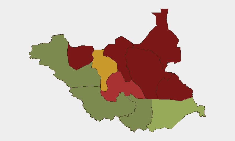
Situation Summary
South Sudan's security environment remains fragmented and volatile, with no verified discrete incidents recorded in the 24–48 hour window ending 4 August 2026. However, underlying drivers—sustained inter-factional hostilities between SSPDF and SPLA-IO, intercommunal violence, and resource-driven criminal activity—remain active across multiple states. The absence of reported events in the immediate window reflects reporting lag and operational tempo variation rather than genuine stabilization. Risk exposure for corporate and expatriate presence remains significant, particularly in northern and eastern regions.
Key Developments
No discrete security incidents have been verified in South Sudan during the 24–48 hours preceding this brief. The most recent tracked event (killing of a county commissioner and health-infrastructure disruption in Jonglei) is dated 7 July 2026 and falls outside the current observation window. Open-source and specialist security monitoring indicates an absence of confirmed events in the immediate reporting period.
For situational awareness, the following underlying risk drivers remain active but are not dated to the last 48 hours:
- Gang activity and abductions in Central Equatoria (Gabor/Morobo area): Reports document 36 civilians abducted with 30 escaped; roads including Juba–Terekeka remain flagged for intensified surveillance due to criminal groups.
- Commercial shipping vulnerability in Jonglei State (Twic East County): Armed attacks on river traffic reported in mid-July; 14 passengers missing in a separate incident approximately two weeks prior to reporting.
- Sustained factional hostilities: SSPDF and SPLA-IO continue low-intensity operations across Unity, Jonglei, and Upper Nile states, driving displacement and supply-chain disruption (confirmed through August 2026 forecasting).
- Intercommunal resource conflict: Pastoral and land-access disputes ongoing across Lakes, Warrap, and Northern Bahr el Ghazal, with seasonal pressure intensifying.
Highest-Risk Areas
Unity (risk 95), Jonglei (93), and Upper Nile (88) remain the three highest-threat zones, driven by overlapping factional territorial claims, limited state authority, and active armed-group operations. These northern and northeastern states constitute the primary locus of inter-factional and intercommunal violence. Greater Pibor Administrative Area (87) and Northern Bahr el Ghazal (82) follow, with localized communal conflict and banditry the dominant threat profile. By contrast, Western Equatoria (38) and Western Bahr el Ghazal State (28) present substantially lower composite risk. Central Equatoria (35), though hosting Juba, carries elevated criminal-activity and gang-related risk despite its administrative status.
How GeoBit Would Assist
Area-of-Interest Monitoring with Early Warning on high-risk states (Unity, Jonglei, Upper Nile) provides persistent surveillance and automated alerting when verified incidents occur, reducing reporting lag. Intel Sweep and OSINT Fusion across local media, humanitarian reports, and regional sources ensures multi-language event corroboration and reduces false-alarm risk. Routing & Network Analysis supports duty-of-care teams in identifying safe transit corridors and alternative routes around active conflict zones and known criminal hotspots. Conflict & Military mapping tracks force-disposition changes that signal shifts in factional control or operational tempo.
7-Day Outlook
No imminent escalation is flagged for the immediate week; however, factional and communal tensions show no sign of de-escalation. Seasonal pastoral migration and resource pressure will likely sustain or modestly elevate intercommunal incidents across pastoral-zone states. Continued vigilance on northern supply routes and river corridors is warranted.
Highest-Risk Areas — Ranked
| # | State / Region | Risk |
|---|---|---|
| 1 | Unity | 95 |
| 2 | Jonglei | 93 |
| 3 | Upper Nile | 88 |
| 4 | Greater Pibor Administrative Area | 87 |
| 5 | Northern Bahr el Ghazal | 82 |
| 6 | Lakes | 78 |
| 7 | Warrap | 72 |
| 8 | Ruweng Administrative Area | 68 |
| 9 | Eastern Equatoria | 52 |
| 10 | Western Equatoria | 38 |
| 11 | Central Equatoria | 35 |
| 12 | Western Bahr el Ghazal State | 28 |
Sources
Previous Daily Briefs
A new South Sudan brief is written every day — each with its own risk map and downloadable CSV. Here's the last week; use the calendar to go further back.
📅 Browse every day by calendar →
Highlighted days have a brief. Tap a day for that day's map & analysis, or “csv” for that day's dataset ($5).
Atlas — our AI intelligence desk — emails them this snapshot personally. Nothing else, no list.