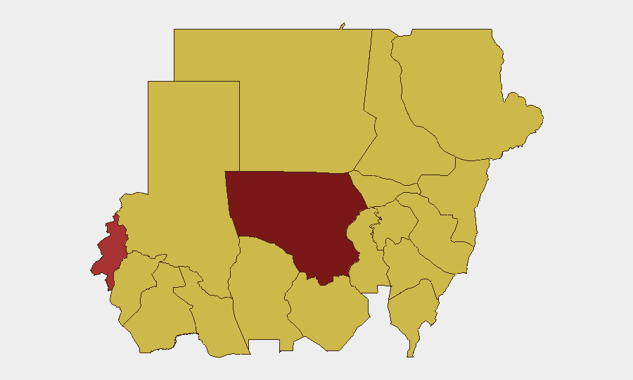
Situation Summary
Sudan remains in active civil war between the Sudanese Armed Forces (SAF) and the Rapid Support Forces (RSF), with escalating conventional military clashes reported as of 13 July 2026. International involvement—including reported Iranian military operations against Sudan—adds complexity to an already fragmented conflict. Civilian displacement, infrastructure destruction, and humanitarian collapse continue to worsen, with North Kordofan State emerging as the single highest-risk flashpoint.
Key Developments
- 13 July · Khartoum – Multiple rounds of conventional military clashes between SAF and RSF reported; WHO issued a public statement regarding Sudan's humanitarian and public-health crisis.
- 13 July · Nationwide – Reports of communal/sectarian violence frame conflict along Christian-Muslim lines, indicating potential expansion beyond state-military actors.
- 13 July · Sudan (Police/Media interface) – Police investigation initiated against media outlets, consistent with pressure on independent reporting during active conflict.
- 12 July · Sudan-Iran border/airspace – Conventional military operations attributed to Iranian forces against Sudan, and retaliatory SAF operations, marking direct great-power military involvement.
- 12 July · Undisclosed location – Arrest and detention of an international envoy; motive and location remain unclear but signal hardening SAF/RSF posture toward mediation.
- 11 July · Darfur – Formal disapproval statements issued by international bodies; ongoing violence and civilian harm continue in the region.
*Note: Web-sourced incident-level verification for the 24–48 hour window was constrained by lack of time-stamped corroboration. The above derives from GeoBit event feeds. Ground-level incident detail from open sources in this window remains limited.*
Highest-Risk Areas
North Kordofan State (risk 100) dominates the threat landscape, driven by sustained SAF-RSF combat operations and reported infrastructure strikes on fuel, water, and power systems. West Darfur (78.6) and Central Darfur (70.5) remain active conflict zones with ongoing communal violence and displacement. Al Khartum (70.3), the capital, shows elevated risk due to urban military operations, police/media tensions, and the arrest of diplomatic personnel. The 70-point cluster spanning South Kordofan, Blue Nile, River Nile, and eastern states (Aj Jazira, Red Sea, Al Qadarif, Kassala, Sennar) reflects both secondary conflict zones and economic/humanitarian strain across the east-central belt. Risk is concentrated but not isolated; personnel and operations across the northern and eastern two-thirds of Sudan face material threat from conventional warfare, communal violence, and state security actions.
How GeoBit Would Assist
Corporate security teams with Sudan exposure should prioritize AOI Monitoring & Early Warning on North Kordofan (El Obeid), Khartoum, and border crossings to detect escalation or displacement surges in near-real time. Conflict & Military battle mapping and force-structure analysis would clarify SAF-RSF disposition and trajectory, enabling route planning and evacuation readiness. Intel Sweep and multi-source OSINT corroboration should be applied daily to verify incident-level reporting and police/media actions that may signal targeting of foreign nationals or NGO staff.
7-Day Outlook
Conventional military intensity is likely to remain elevated through mid-late July, with North Kordofan and Khartoum as primary flashpoints. No negotiated pause is signaled; international military involvement (Iran) may widen the scope of operations. Humanitarian conditions will deteriorate; border crossings and aid corridors should be monitored for closure or attack.
Highest-Risk Areas — Ranked
| # | State / Region | Risk |
|---|---|---|
| 1 | North Kordofan State | 100 |
| 2 | West Darfur | 78.6 |
| 3 | Central Darfur State | 70.5 |
| 4 | Al Khartum | 70.3 |
| 5 | South Kordofan | 70.3 |
| 6 | Blue Nile | 70 |
| 7 | River Nile State | 70 |
| 8 | Aj Jazira | 70 |
| 9 | Red Sea State | 70 |
| 10 | Al Qadarif State | 70 |
| 11 | Kassala State | 70 |
| 12 | Sennar State | 70 |
Sources
Previous Daily Briefs
A new Sudan brief is written every day — each with its own risk map and downloadable CSV. Here's the last week; use the calendar to go further back.
📅 Browse every day by calendar →
Highlighted days have a brief. Tap a day for that day's map & analysis, or “csv” for that day's dataset ($5).
Atlas — our AI intelligence desk — emails them this snapshot personally. Nothing else, no list.