Situation Summary
Suriname remains a low-threat environment globally (ranked #175) with no broad civil unrest or political instability reported as of 29 August 2026. However, a high-profile criminal investigation into the disappearance of Dutch entrepreneur Rodney Leysner has intensified over the past 72 hours, with police confirming recovery of his burned vehicle in Saramacca district and detaining multiple suspects on suspicion of murder and organized crime. Separately, an environmental incident involving mass fish deaths in Boven-Saramacca has prompted emergency government coordination, signaling potential water-quality or contamination risks in the interior.
Key Developments
- Leysner vehicle recovered, Saramacca district (27–28 August): Surinamese police excavated a burned and crushed white Kia from a swampy area west of Paramaribo; chassis confirmation indicates it belonged to missing Dutch producer Rodney Leysner. Vehicle condition and location suggest possible violent crime and disposal attempt. Body has not yet been recovered.
- Murder suspect wanted nationwide (26–28 August): Prosecutors issued a wanted notice for Ryan T., implicated in Leysner's disappearance on suspicion of murder, manslaughter, assault, unlawful imprisonment, and participation in a criminal organization. Suspect is believed to be at large.
- Three suspects detained in Leysner case (26–28 August, Paramaribo): Police have arrested a Cuban married couple and a Surinamese national in connection with the disappearance, indicating multi-national involvement and organized crime dimensions.
- Mass fish die-off triggers emergency meeting (27–28 August, Boven-Saramacca interior): Surinamese government convened urgent meeting ("spoedberaad") following reported mass fish deaths in Boven-Saramaccawaterkant region. Cause not yet public; potential for water contamination, disrupted river transport, or community unrest if environmental negligence perceived.
- Ongoing fundraising and search operations: Cross-border campaign for Leysner search and recovery has raised over €16,600, with active investigative operations continuing through late August.
- Third day of protest activity (26 August, Paramaribo region, likely ongoing): Local source reported protest entering its third day on 26 August; specific cause and current status unclear from available reporting, but suggests organized civil mobilization that may persist into briefing date.
Highest-Risk Areas
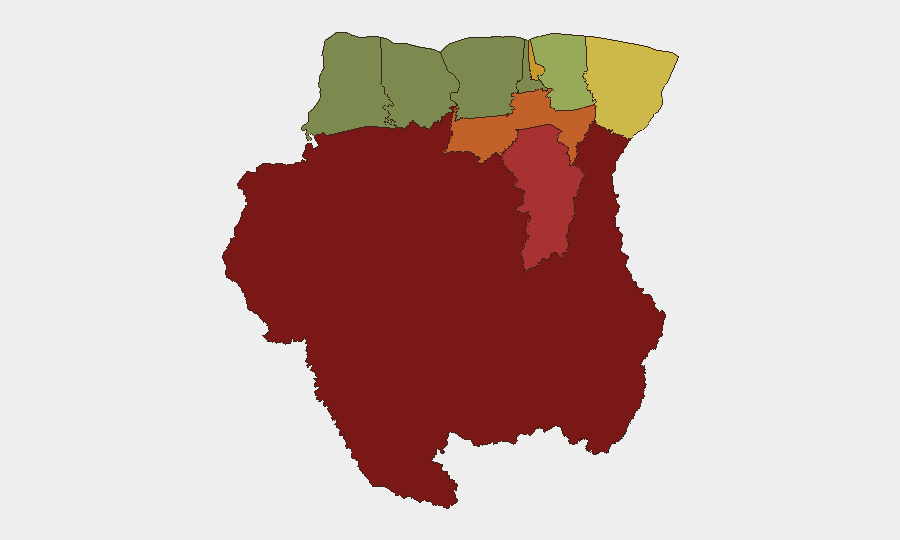
Sipaliwini (risk 92), Brokopondo (78), and Para (74) drive the national composite score, reflecting chronic organized crime, gold-mining trafficking, and drug-trafficking activity in remote interior zones. Paramaribo (71) and Marowijne (68) represent urban and border risks respectively, with the capital now hosting an active high-profile criminal investigation. The Leysner case and Saramacca vehicle recovery indicate that organized-crime violence is not confined to interior zones but extends into peri-urban Saramacca district (29), elevating risk for personnel working in or transiting west of the capital.
How GeoBit Would Assist
Corporate teams with personnel or assets in Suriname should employ Intel Sweep and X/Twitter OSINT to monitor unfolding developments in the Leysner case and any protest escalation; multi-language search and event-feed fusion to surface emerging environmental or water-quality reports in Boven-Saramacca that could affect operations or logistics; and AOI Monitoring & Early Warning on high-risk districts (Sipaliwini, Brokopondo, Saramacca) to detect upticks in organized-crime or civil unrest activity before they reach international media.
7-Day Outlook
The Leysner investigation is expected to remain high-profile and active; body recovery and further arrests remain possible, with attendant media attention and potential public reaction. The Boven-Saramacca environmental incident will likely require follow-up government briefings and environmental assessment, with implications for river-based supply chains and community stability. Absent new political shocks or violence, Suriname's overall threat level is unlikely to rise materially in the next week, but security teams should monitor Paramaribo and Saramacca districts closely for organized-crime spillover or protest-related disruptions.
Highest-Risk Areas — Ranked
| # | State / Region | Risk |
|---|---|---|
| 1 | Sipaliwini | 92 |
| 2 | Brokopondo | 78 |
| 3 | Para | 74 |
| 4 | Paramaribo | 71 |
| 5 | Marowijne | 68 |
| 6 | Commewijne | 42 |
| 7 | Wanica | 38 |
| 8 | Saramacca | 29 |
| 9 | Coronie | 12 |
| 10 | Nickerie | 8 |
Sources
Previous Daily Briefs
A new Suriname brief is written every day — each with its own risk map and downloadable CSV. Here's the last week; use the calendar to go further back.
- August 26, 2026
- August 23, 2026
- August 20, 2026
- August 18, 2026
- August 16, 2026
- August 14, 2026
- August 12, 2026
📅 Browse every day by calendar →
Highlighted days have a brief. Tap a day for that day's map & analysis, or “csv” for that day's dataset ($5).
Atlas — our AI intelligence desk — emails them this snapshot personally. Nothing else, no list.