Situation Summary
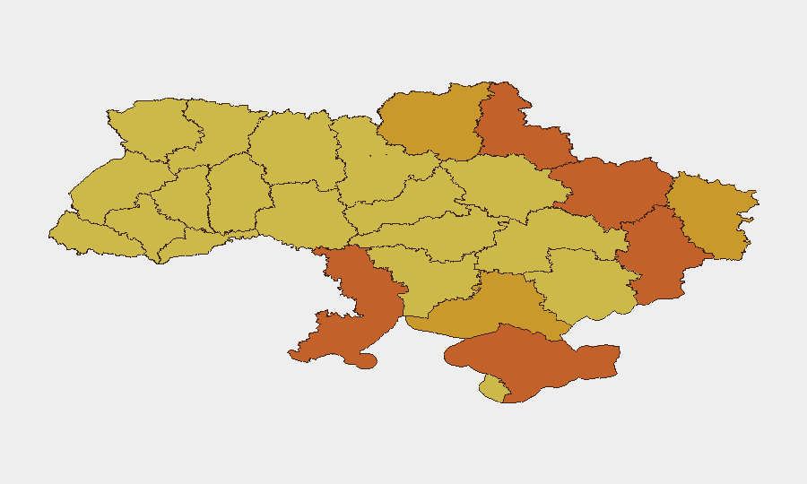
Ukraine remains the highest-threat country globally (composite score 100) with 978 tracked events, driven by active conventional and unconventional warfare spanning all major regions. Command-level personnel changes, reported strikes on Russian logistics and shadow-fleet assets, and sustained cross-border strikes indicate operational momentum shifts and potential institutional instability. Kyiv remains the single highest-risk location (100), with eastern and southern oblasts (Donetsk, Kharkiv, Crimea, Odesa) clustered at 71–75, reflecting active frontline and rear-area threat concentration. Current trajectory is volatile with no de-escalation signals.
Key Developments
- Kyiv — July 26–27, 2026: Ukrainian President Zelensky appointed Mykhailo Drapatyi as Commander-in-Chief, replacing the previous commander following sustained public and political pressure. This signals potential operational or strategic reorientation at the highest military level.
- St. Petersburg, Russia — July 26–27, 2026: Ukrainian strikes reportedly ignited fires at two Wildberries logistics warehouses, part of an ongoing campaign targeting Russian supply-chain infrastructure.
- Black Sea / Azov Sea — July 26–28, 2026: Ukrainian forces reportedly engaged 13 vessels of Russia's "shadow fleet" within a 48-hour window, indicating sustained maritime interdiction operations.
- Ukraine nationwide — July 27–28, 2026: Russian strikes across multiple regions killed at least 12 civilians and damaged residential areas; southern-region strikes also sparked widespread fires, suggesting either escalated strike intensity or reduced air-defense capacity in affected sectors.
- Ukraine nationwide — July 28, 2026: Russian Ministry and Kyiv authorities issued public rejections of unspecified proposals or statements (2026-07-26 and 2026-07-26 signals), indicating diplomatic or negotiation breakdown or hardened negotiating positions.
- Iran–Ukraine / Iran–US — July 27, 2026: Iran issued threats toward Ukraine and reportedly engaged in conventional military operations versus US forces, widening the conflict's regional footprint and indicating potential Iranian escalation or new theater opening.
Highest-Risk Areas
Kyiv dominates the risk landscape (100) as the capital, seat of government, and primary civilian/infrastructure target. The eastern corridor—Donetsk (75.3), Kharkiv (73.7), and Luhansk (71.3)—represents the active ground-warfare front and experiences the highest frequency of conventional strikes. Crimea and southern oblasts (Odesa, Kherson, Zaporizhia) remain contested and subject to intensive cross-border and maritime operations. Western oblasts (Lviv, Ternopil) score 70+, likely reflecting cumulative strike exposure despite distance from front lines, and continued drone/missile transit risk.
How GeoBit Would Assist
Intel Sweep and OSINT fusion across X/Telegram, open-source news, and conflict databases enable duty-of-care teams to corroborate incident reports (strikes, casualties, command changes) in near-real-time and identify patterns in targeting. AOI (Area-of-Interest) Monitoring & Early Warning with persistent watch on Kyiv, eastern oblasts, and Black Sea approaches provides 24/7 alerting when activity escalates in specific assets' proximity. Conflict & Military mapping, force-structure tracking, and battle mapping clarify frontline volatility and commander-level changes, informing evacuation and operational-continuity decisions.
7-Day Outlook
Command-level personnel replacement and sustained cross-border strikes suggest Ukraine is entering a phase of operational reorientation while under sustained Russian pressure. Iranian involvement signals potential widening of the conflict or new supply lines opening. Risk levels in Kyiv and eastern oblasts will likely remain at current highs; escalation vectors include deepening regional involvement and targeting of civilian infrastructure to achieve political effect.
Highest-Risk Areas — Ranked
| # | State / Region | Risk |
|---|---|---|
| 1 | Kyiv | 100 |
| 2 | Donetsk Oblast | 75.3 |
| 3 | Kharkiv Oblast | 73.7 |
| 4 | Autonomous Republic of Crimea | 73.7 |
| 5 | Odesa Oblast | 73.6 |
| 6 | Sumy Oblast | 73.4 |
| 7 | Kherson Oblast | 71.6 |
| 8 | Chernihiv Oblast | 71.6 |
| 9 | Luhansk Oblast | 71.3 |
| 10 | Zaporizhia Oblast | 70.9 |
| 11 | Lviv Oblast | 70.7 |
| 12 | Ternopil Oblast | 70.5 |
Sources
Previous Daily Briefs
A new Ukraine brief is written every day — each with its own risk map and downloadable CSV. Here's the last week; use the calendar to go further back.
📅 Browse every day by calendar →
Highlighted days have a brief. Tap a day for that day's map & analysis, or “csv” for that day's dataset ($5).
Atlas — our AI intelligence desk — emails them this snapshot personally. Nothing else, no list.