Situation Summary
The United States maintains composite threat score of 93 (rank #12 globally) with 5,642 tracked events, reflecting elevated but not critical risk posture. Recent 24–48-hour intelligence indicates concurrent federal law-enforcement action on cyber (domain seizures, leak investigation task force), immigration enforcement (fatal incident in Maine, evidence handover in Minnesota case), and localized civil disturbance (Rochester area unconventional violence and small-arms engagement with authorities). The threat profile is dispersed across multiple threat vectors rather than concentrated in a single flashpoint.
Key Developments
- Washington, D.C. (13 July 2026): Department of War suspended CMMC Phase II cybersecurity compliance requirements for defense contractors, reverting to Phase I self-assessment; operational impact on supply-chain security posture ongoing.
- FBI / Multi-sector (14 July 2026): FBI domain-seizure operation against NetNut residential proxy service completed in coordination with private industry partners; indicates coordinated action against infrastructure enabling fraud/evasion.
- DOJ / Pentagon (14 July 2026, this week): Joint task force established to investigate unauthorized leaks of classified/sensitive information to media; signals heightened insider-threat and information-security concern at federal level.
- Maine (14 July 2026, reported Monday): Fatal shooting incident involving U.S. Immigration and Customs Enforcement during enforcement operation; specific circumstances under investigation.
- Rochester area, New York (14 July 2026): Small-arms combat between armed actors and law-enforcement/authorities; school investigatory response initiated; unclear casualty count and active-incident status requires monitoring.
- Minneapolis, Minnesota (14 July 2026, reported Monday): Federal authorities transferred evidence in January 2026 deportation-sweep cases involving fatalities (Renee Good, Alex Pretti) and wounding of third party; legal/civil-liability process ongoing.
Highest-Risk Areas
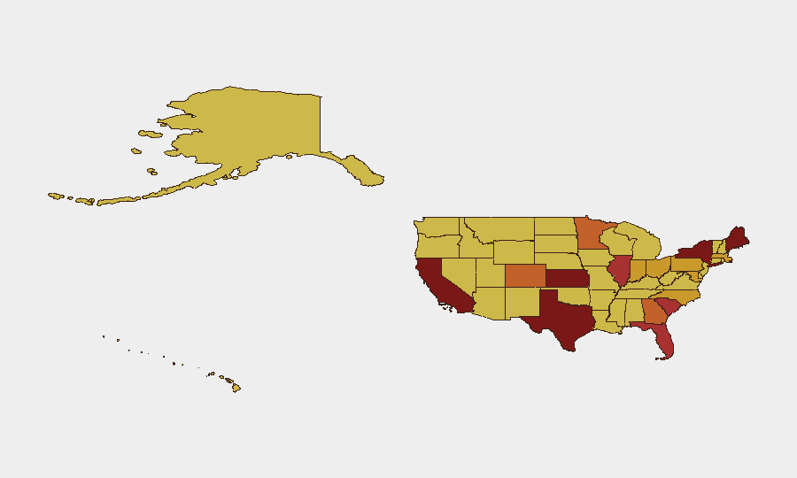
California (94.8), Kansas (92.1), and Texas (87.9) drive the highest composite risk nationally, likely reflecting large metropolitan populations, cross-border activity, and concentrated critical infrastructure. Maine (87.6) and New York (87.5) rank 4th–5th, with recent incidents in Rochester and a fatal ICE operation in Maine correlating with those elevated scores. The geographic spread across West, Midwest, Northeast, and South indicates no single regional concentration; however, states with mixed urban-rural density and significant federal presence (immigration, military, law enforcement) show higher event frequency. California's sustained 94.8 score reflects ongoing civil-unrest indicators, cybercrime, and cross-border smuggling activity.
How GeoBit Would Assist
Organizations with personnel or assets in ranked high-risk states should deploy AOI Monitoring & Early Warning on Rochester, California urban centers, and cross-border Texas and Maine zones to detect emerging civil-unrest, criminal-activity, and law-enforcement response signals in real time. Network & Actor Analysis combined with Intel Sweep (X/Twitter OSINT, multi-language feeds, entity extraction) would provide 24–48-hour advance notice of planned protests, armed-group activity, or ICE operations affecting workforce or supply-chain routes. Routing & Network Analysis enables alternate-journey planning for personnel transiting high-risk corridors, particularly Maine–Canada and Texas–Mexico border zones.
7-Day Outlook
Federal law-enforcement tempo (cyber, leak investigation, immigration enforcement) is expected to sustain or increase through mid-July; concurrent local violence in Rochester suggests potential for additional law-enforcement mobilization and possible traffic/mobility disruption in upstate New York. Risk remains dispersed and below critical threshold, but organizations in California, Kansas, Texas, Maine, and New York should maintain heightened monitoring and personnel-safety protocols.
Highest-Risk Areas — Ranked
| # | State / Region | Risk |
|---|---|---|
| 1 | California | 94.8 |
| 2 | Kansas | 92.1 |
| 3 | Texas | 87.9 |
| 4 | Maine | 87.6 |
| 5 | New York | 87.5 |
| 6 | Illinois | 77.9 |
| 7 | South Carolina | 77.5 |
| 8 | Florida | 76.7 |
| 9 | Minnesota | 75.5 |
| 10 | Georgia | 75 |
| 11 | Colorado | 73.8 |
| 12 | Pennsylvania | 72.5 |
Sources
Previous Daily Briefs
A new United States brief is written every day — each with its own risk map and downloadable CSV. Here's the last week; use the calendar to go further back.
📅 Browse every day by calendar →
Highlighted days have a brief. Tap a day for that day's map & analysis, or “csv” for that day's dataset ($5).
Atlas — our AI intelligence desk — emails them this snapshot personally. Nothing else, no list.