Situation Summary
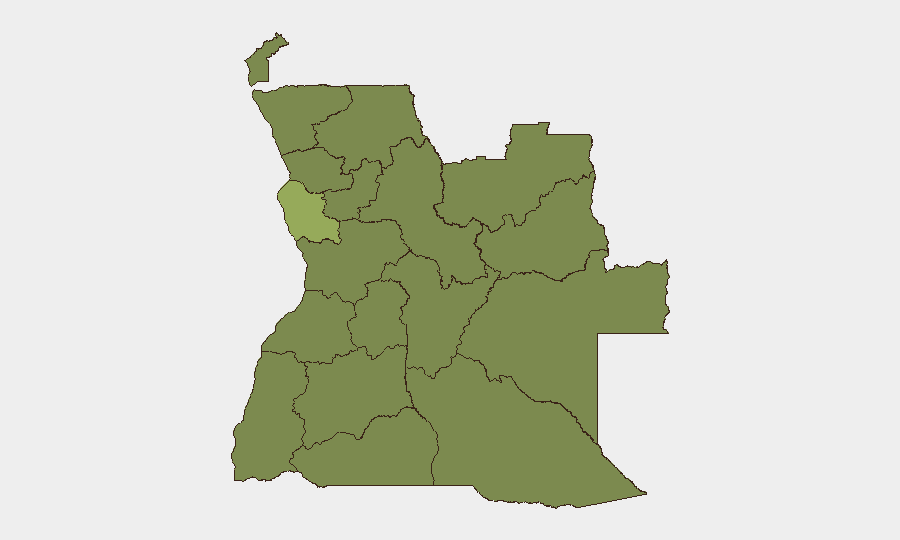
Angola remains a moderate-complexity security environment (global rank #45) with composite threat score 35 across 358 tracked events. The security picture is dominated by concentrated urban crime in Luanda Province (risk 24+ points higher than all other regions), wildfire incidents across multiple provinces, and localized street violence—rather than organized conflict or political instability. The trajectory shows persistent endemic crime risks in the capital balanced against absence of acute state collapse or armed-group escalation.
Key Developments
- Luanda street homicide, 21 July: A male victim found deceased with apparent gunshot trauma in Cacuaco district (Luanda Province)—consistent with ongoing street-crime pattern in the capital but not indicative of organized violence surge.
- Wildfire activity, recent (late July): Multiple fire incidents tracked across Angola (event IDs 1029755, 1029756, 1029753, 1029684, 1029687, 1029796, 1029689, 1029717, 1029760, 1029763, 1029783). Specific locations, dates, and affected provinces require drill-down on individual event records; wildfires pose secondary risks (air quality, population displacement, infrastructure exposure) in affected zones.
- Public statement alert, 27 July: A neighborhood-level public statement flagged in Angola today; content and location not yet detailed in available results and warrant real-time monitoring.
- Standing travel-risk advisories (Spain foreign ministry, recent): Elevated street crime in Luanda remains official advisory guidance; no new spike reported, but confirms persistent pickpocketing, robbery, and violent crime in central and peripheral Luanda districts.
- Regional diplomatic context: Angola has engaged ceasefire-proposal mediation in the DR Congo crisis, but this is external engagement rather than domestic security incident.
Highest-Risk Areas
Luanda Province overwhelmingly dominates the risk landscape (score 54.6), driven by concentrated street crime, armed robbery, and homicide in dense urban zones, particularly Cacuaco and central commercial districts. All other provinces cluster at risk 24.6, suggesting either data harmonization effects or that risks outside the capital are either lower or underreported. Security teams with personnel or assets in Luanda should assume elevated ambient threat from opportunistic crime and apply standard urban mitigation (route discipline, situational awareness, after-hours movement constraints). Personnel in Lunda Norte/Sul, Cabinda, and Zaire should monitor wildfire impacts and maintain contingency routes; Bengo and Cuanza provinces warrant baseline vigilance but no acute indicators at present.
How GeoBit Would Assist
AOI Monitoring & Early Warning establishes persistent watch on Luanda high-crime districts and wildfire zones with automated alerting on new incidents, enabling duty-of-care teams to brief travelers before deployment. OSINT Fusion & Corroboration cross-references street crime reports, police data, and X/Telegram chatter to verify threat credibility and distinguish criminal versus organized-group violence. GIS & Spatial Analysis maps crime clusters and wildfire perimeters to inform alternative routing and safe-zone identification for mobile teams.
7-Day Outlook
Luanda street crime is expected to remain elevated and endemic over the next week with no indication of organized escalation or political trigger. Wildfire activity will likely persist in affected provinces through late July depending on weather; teams should monitor air quality and road closure updates. No acute political or security threshold is expected to materially worsen Angola's overall risk posture in the immediate term absent external regional spillover.
Highest-Risk Areas — Ranked
| # | State / Region | Risk |
|---|---|---|
| 1 | Luanda Province | 54.6 |
| 2 | Lunda Norte Province | 24.6 |
| 3 | Lunda Sul Province | 24.6 |
| 4 | Cabinda Province | 24.6 |
| 5 | Zaire Province | 24.6 |
| 6 | Bengo Province | 24.6 |
| 7 | Uíge Province | 24.6 |
| 8 | Cuanza Norte Province | 24.6 |
| 9 | Cuanza Sul Province | 24.6 |
| 10 | Malanje Province | 24.6 |
| 11 | Bié Province | 24.6 |
| 12 | Moxico Province | 24.6 |
Sources
Previous Daily Briefs
A new Angola brief is written every day — each with its own risk map and downloadable CSV. Here's the last week; use the calendar to go further back.
📅 Browse every day by calendar →
Highlighted days have a brief. Tap a day for that day's map & analysis, or “csv” for that day's dataset ($5).
Atlas — our AI intelligence desk — emails them this snapshot personally. Nothing else, no list.