Situation Summary
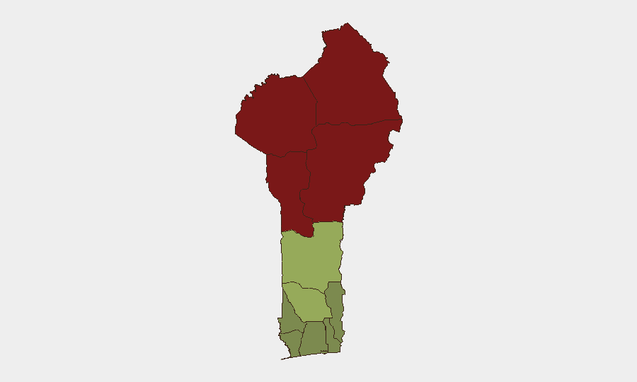
Benin's security environment remains dominated by terrorism and insurgency threats concentrated in the northern frontier departments, particularly Alibori, Atakora, Donga, and Borgou, which together account for the country's highest composite risk scores (83–92). Cross-border spillover from the Sahel and Nigeria-Benin frontier instability—including kidnapping networks operating along major transport corridors—continues to drive national-level concern and coordinated multinational response. No major acute incident has been independently verified in Benin proper within the last 24–48 hours; current activity centers on stabilization measures and bilateral security cooperation rather than new conflict or crime events.
Key Developments
- Cotonou (10 Aug 2026): National Guard presence increased as part of ongoing public-safety and stabilization effort in the commercial capital; no specific incident trigger identified in available reporting.
- Nationwide (Cyber, 10 Aug 2026): CNIN (Benin's cybercrime authority) is investigating a TikTok live-stream case involving detentions and evidence seizure related to cybercrime; scope and perpetrators remain under investigation.
- Benin-Nigeria Border (4 Aug 2026, context-setting): Benin and Nigerian defense officials deepened military and security cooperation frameworks and anti-terrorism partnership in response to documented frontier insecurity; reflects ongoing institutional response rather than a new acute threat.
No verified new security incidents (conflict, terrorism, kidnapping, major crime) occurred in Benin within the 24–48 hour window. Recent activity is predominantly strategic/diplomatic (bilateral defense meetings, increased National Guard positioning) and cyber-investigation focused.
Highest-Risk Areas
Benin's threat profile is geographically bifurcated. The four northern departments—Alibori (92), Atakora (88), Donga (85), and Borgou (83)—account for critical terrorism and insurgency risk, driven by proximity to Niger and Nigerian Sahel conflict zones, porous borders, and documented militant movement. Zou Department (45) and Collines (42) represent a secondary risk belt, while southern coastal departments (Ouémé, Littoral, Atlantique) remain substantially lower-risk. Risk concentration in the north reflects both the geographic spillover of trans-Saharan extremist networks and kidnapping/banditry operations targeting transport and commercial movement along the Benin-Lagos corridor and internal trunk routes. Corporate and NGO personnel, supply chains, and critical infrastructure in the north face heightened exposure.
How GeoBit Would Assist
Security and risk teams operating in Benin should prioritize AOI Monitoring & Early Warning on the four highest-risk departments (Alibori, Atakora, Donga, Borgou) paired with Intel Sweep and X/Twitter & Telegram OSINT to detect emerging kidnapping, militant activity, or checkpoint/roadblock developments before they affect travel and operations. Routing & Network Analysis capabilities support identification of lower-risk alternate routes for personnel and cargo movement, particularly along the Benin-Lagos and cross-border corridors. Satellite & Imagery analysis and GIS & Spatial Analysis enable real-time monitoring of military/National Guard positioning, crossing points, and trafficking choke-points in high-risk zones.
7-Day Outlook
Benin's security posture is likely to remain stable in the southern and central zones over the next 7 days, with no indicators of acute deterioration. Northern departments will continue to operate under elevated baseline risk; continued National Guard and bilateral operations with Nigeria should sustain the current equilibrium, though seasonal and cross-border militant activity could introduce tactical disruptions. Monitor bilateral defense meetings and any shift in checkpoint/closure activity as early indicators of changing threat perception.
Highest-Risk Areas — Ranked
| # | State / Region | Risk |
|---|---|---|
| 1 | Alibori Department | 92 |
| 2 | Atakora Department | 88 |
| 3 | Donga Department | 85 |
| 4 | Borgou Department | 83 |
| 5 | Zou Department | 45 |
| 6 | Collines Department | 42 |
| 7 | Plateau Department | 38 |
| 8 | Kouffo Department | 35 |
| 9 | Mono Department | 32 |
| 10 | Atlantique Department | 28 |
| 11 | Littoral | 25 |
| 12 | Ouémé Department | 22 |
Sources
Previous Daily Briefs
A new Benin brief is written every day — each with its own risk map and downloadable CSV. Here's the last week; use the calendar to go further back.
📅 Browse every day by calendar →
Highlighted days have a brief. Tap a day for that day's map & analysis, or “csv” for that day's dataset ($5).
Atlas — our AI intelligence desk — emails them this snapshot personally. Nothing else, no list.