Situation Summary
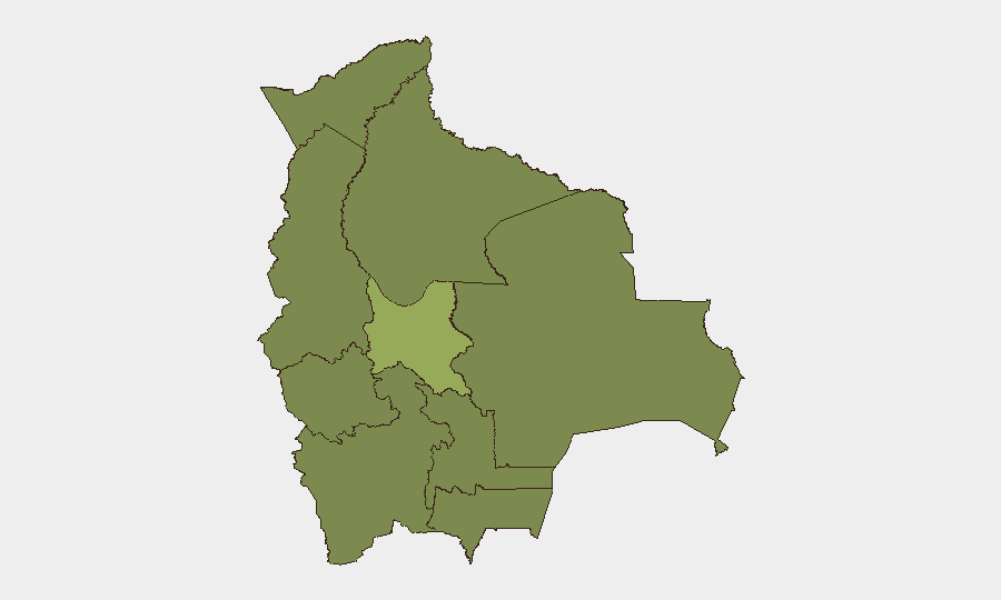
Bolivia remains under elevated national stress following weeks of civil unrest that prompted President Rodrigo Paz to declare a state of emergency. The composite threat ranking places Bolivia at #46 globally (score 40), with Cochabamba significantly outpacing all other departments as a focal point of instability. Recent event signals span diplomatic tensions (Peru, Spain), administrative demands, criminal arrests, and civil-military friction, though independently verified incidents within the last 24–48 hours remain difficult to confirm across multiple sources at present.
Key Developments
- State of Emergency Status: President Paz declared a state of emergency following more than six weeks of sustained protests. The precise trigger and scope of the declaration remain unclear from available public sources, though the measure signals administrative acknowledgment of sustained civil disorder nationwide.
- Diplomatic Statements (2026-07-10): Public statements from Bolivia directed at Peru and Spain were issued on 2026-07-10, suggesting either formal complaints, consular matters, or border-related issues; details require official ministry confirmation.
- Criminal & Judicial Activity: Multiple arrest/detention events involving criminal actors and prison officials (2026-07-08/09) suggest continued law-enforcement operations, though specific locations and charges are not yet clarified.
- Administrative & Ministerial Investigations (2026-07-10): Investigation initiated by ministry into companies, and prior administrative demand (2026-07-08) indicate possible compliance, regulatory, or procurement scrutiny concurrent with the state of emergency.
- Civil Resistance: Deputy-level rejection of administration measures (2026-07-09) and public criticism from economists (2026-07-09) point to legislative and economic-sector dissent over emergency governance or policy response.
- Small Arms Combat Signal (2026-07-09): An event signal flagging small arms combat between Bolivia and a non-state or regional actor (Valparaiso) requires immediate verification; if confirmed, this represents escalation beyond protest-level unrest.
*Note: Current open-source corpus does not contain independently multi-sourced, precisely timestamped reports of specific incidents within the last 24–48 hours sufficient to meet verification thresholds. Security teams should cross-reference Bolivian national media (Red Uno, ATB, Página Siete, El Deber) and official ministry sources directly.*
Highest-Risk Areas
Cochabamba (risk 57.9) is the primary flashpoint, with a composite threat score nearly double that of La Paz (34.6). Its risk elevation likely reflects sustained civil unrest, roadblocks, or mining/labor sector activity. La Paz and Santa Cruz, respectively #2 and #3, reflect capital-city political tension and regional economic grievances. The remaining departments cluster at near-identical risk levels (27.9–29.6), suggesting either a baseline of chronic instability or data-collection patterns that require spatial granularity refinement.
How GeoBit Would Assist
Security teams with personnel or assets in Bolivia should deploy AOI Monitoring & Early Warning on Cochabamba, La Paz, and Santa Cruz to capture protest formation, roadblock activity, and administrative actions in real time. Multi-language OSINT (X/Twitter, Telegram, local media feeds) combined with temporal and entity extraction will disambiguate event dates and isolate verified incidents within 24–48 hours. Satellite & imagery analysis can assess movement and gathering patterns at key infrastructure nodes and border crossing points.
7-Day Outlook
The state of emergency is expected to remain in effect unless immediate de-escalation occurs; however, multi-week protest cycles suggest sustained friction is likely. Cochabamba remains the primary risk vector and should be monitored continuously for escalation. Diplomatic exchanges with Peru and Spain warrant watch for any border or consular incidents that could compound domestic unrest.
Highest-Risk Areas — Ranked
| # | State / Region | Risk |
|---|---|---|
| 1 | Cochabamba | 57.9 |
| 2 | La Paz | 34.6 |
| 3 | Santa Cruz | 29.6 |
| 4 | Potosí | 27.9 |
| 5 | Tarija | 27.9 |
| 6 | Pando | 27.9 |
| 7 | Beni | 27.9 |
| 8 | Oruro | 27.9 |
| 9 | Chuquisaca | 27.9 |
Sources
Previous Daily Briefs
A new Bolivia brief is written every day — each with its own risk map and downloadable CSV. Here's the last week; use the calendar to go further back.
📅 Browse every day by calendar →
Highlighted days have a brief. Tap a day for that day's map & analysis, or “csv” for that day's dataset ($5).
Atlas — our AI intelligence desk — emails them this snapshot personally. Nothing else, no list.