Situation Summary
Central African Republic remains at composite threat level 77 (rank #32 globally), with no discrete security events recorded in the current 24–48 hour window. The security environment is characterized by persistent instability across the northeast and east, driven by armed group activity, resource competition, and weak state capacity in remote prefectures. No imminent escalation or de-escalation signals are present in current open reporting.
Key Developments
No credible, time-stamped security, conflict, crime, or civil-unrest incidents specific to Central African Republic have been corroborated in open sources within the last 24–48 hours. International news flow currently emphasizes other crises (Middle East, DRC Ebola response); CAR-specific reporting in this window is absent from major wire services and regional outlets.
Recommended monitoring approach: Security teams should activate dedicated OSINT feeds (MINUSCA advisories, humanitarian NGO situation reports, regional journalist networks on X/Twitter) to detect any emerging incident with independent corroboration before operational response.
Highest-Risk Areas
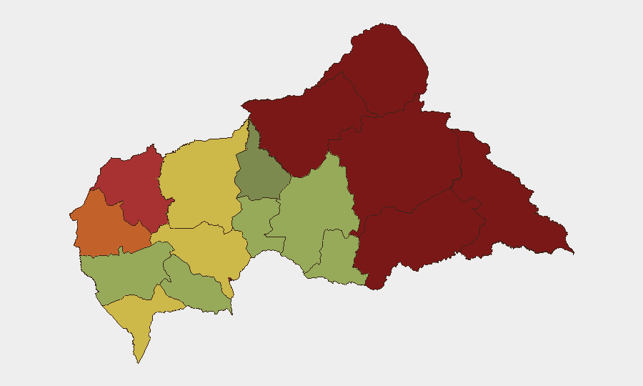
Vakaga (risk 95), Bamingui-Bangoran (92), and Haute-Kotto (88) comprise the highest-risk tier, all located in the remote northeast and east. These prefectures are characterized by sparse state presence, active armed-group competition, and limited humanitarian access—conditions that enable both organized violence and criminal exploitation. Bangui (78) and surrounding Ombella-M'Poko (62) remain at moderate-to-elevated risk despite capital-city infrastructure; urban crime, inter-communal tension, and checkpoint extortion affect movement and supply-chain operations. Western and southwestern regions (Ouham, Sangha-Mbaéré, Nana-Mambéré) show lower composite scores but remain subject to sudden localized events tied to cross-border flows and resource trafficking.
How GeoBit Would Assist
AOI Monitoring & Early Warning provides persistent, persistent watch of high-risk prefectures (Vakaga, Bamingui-Bangoran, Haute-Kotto) with near-real-time alerting on armed-group movement, checkpoints, and conflict indicators. OSINT fusion & corroboration (X/Twitter, MINUSCA, humanitarian feeds, multi-language search) enables rapid validation of emerging incidents and differentiation of rumor from credible threat. Routing & Network Analysis supports alternative journey planning and supply-chain rerouting around identified hotspots, while Conflict & Military force-structure and weapons-capability tracking inform risk modeling for regions with known armed-group presence.
7-Day Outlook
No significant escalation or de-escalation is signaled in the current reporting window. The security posture is expected to remain static—chronic instability in the northeast and east, with intermittent localized incidents in transit corridors and resource-extraction areas. Any material change would likely emerge first in MINUSCA situation reports or humanitarian NGO assessments, warranting continuous light-touch monitoring by teams with people or assets in-country.
Next GeoBit Daily Brief (CAR): 2026-07-13, 08:00 UTC
Highest-Risk Areas — Ranked
| # | State / Region | Risk |
|---|---|---|
| 1 | Vakaga | 95 |
| 2 | Bamingui-Bangoran | 92 |
| 3 | Haute-Kotto | 88 |
| 4 | Haut-Mbomou | 85 |
| 5 | Mbomou | 82 |
| 6 | Ouham-Pendé | 79 |
| 7 | Bangui | 78 |
| 8 | Nana-Mambéré | 75 |
| 9 | Sangha-Mbaéré | 68 |
| 10 | Ouham | 65 |
| 11 | Ombella-M'Poko | 62 |
| 12 | Kémo | 58 |
Sources
Previous Daily Briefs
A new Central African Republic brief is written every day — each with its own risk map and downloadable CSV. Here's the last week; use the calendar to go further back.
📅 Browse every day by calendar →
Highlighted days have a brief. Tap a day for that day's map & analysis, or “csv” for that day's dataset ($5).
Atlas — our AI intelligence desk — emails them this snapshot personally. Nothing else, no list.