Situation Summary
Chad remains a Level 4 "Do Not Travel" jurisdiction, ranked #26 globally with a composite threat score of 67. Over the past 24–48 hours, no major new security incidents have been verified in open-source reporting; the current threat profile is dominated by ongoing structural risks—terrorism, armed-group activity, violent crime, and border instability—rather than acute escalation. Recent military operations against non-state armed groups (notably the MPRD) and sustained counter-terrorism restrictions in Lac Province underscore persistent baseline insecurity, but no fresh flashpoint events have materialized in the immediate period.
Key Developments
- No major verified incidents in the last 24–48 hours. A consolidated security bulletin dated 15 July explicitly confirms that no significant new events have been reported in current open-source feeds for this window, indicating the threat picture remains stable relative to existing conditions rather than deteriorating sharply.
- Korbol, Moyen-Chari Province – 18 July 2026 (reported 19 July). Chadian army units engaged MPRD rebels approximately 20 km from Korbol in a midday operation; at least 22 combatant fatalities (17 rebel, 5 soldier) were recorded. This represents recent but >48-hour-old military activity consistent with ongoing counter-insurgency tempo.
- Lac Province curfew and restrictions remain in force. An emergency regime and night curfew (20:00–06:00) continue, including prohibitions on boat/pirogue use between 18:00 and 06:00, implemented to sustain counter-terrorism controls. No fresh attacks on military or security facilities have been reported in the most recent 24–48 hour cycle.
- N'Djamena street assault, 15 July (>72 hours prior). A reported assault on a civilian near Camp 27 around 22:00 resulted in police intervention and evacuation to the Central Hospital. This reflects ongoing street-crime risk in the capital but falls outside the 24–48 hour window.
- Political detention and human-rights concerns (17 July dispatch). Eight opposition figures detained on "inciting insurrection" charges continue to be held in reported "deplorable" conditions with documented health deterioration. This signals ongoing regime-stability and human-rights risk but does not constitute a new security incident.
- U.S. State Department Level 4 advisory remains current. The highest travel warning classification persists across Chad due to terrorism, kidnapping, and limited consular capacity, placing the country alongside only ten other African jurisdictions in this category.
Highest-Risk Areas
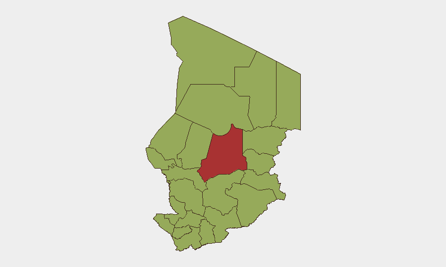
Batha Province (risk score 77) stands alone as the highest-risk sub-national zone, approximately 63% above the national baseline. A second tier of eleven provinces and the capital—including Ennedi-Ouest, Wadi Fira, Ouaddaï, Lac, and N'Djamena—cluster at risk score 47. The concentration of threat in Batha reflects documented armed-group presence, border proximity to Sudan and the Central African Republic, and ongoing insurgent activity; Lac Province's elevated risk is tied to counter-terrorism operations and humanitarian displacement from Lake Chad basin instability. The capital's inclusion in the secondary tier underscores persistent street crime and political-detention concerns despite its urban-center status.
How GeoBit Would Assist
Security teams would deploy AOI Monitoring & Early Warning on Batha, Lac, and Moyen-Chari provinces to detect armed-group movement or military operations with automated alerting. Intel Sweep and OSINT fusion across multi-language sources, X/Twitter, and Telegram would provide real-time verification of rumors and incident reports to distinguish signal from noise. Routing & Network Analysis would enable alternative journey planning for staff and asset movement, while Conflict & Military tracking would maintain current visibility on MPRD and other non-state actor force posture and capabilities.
7-Day Outlook
No imminent escalation is signaled by current reporting; the security environment is expected to remain at present baseline levels, characterized by ongoing counter-terrorism operations and structural instability rather than sudden deterioration. However, the dry season and Ramadan period historically correlate with increased armed-group activity in the Sahel, warranting sustained monitoring of Batha and Lac provinces for uptick in incidents. Staff and asset security postures should assume Level 4 conditions persist through the forecast window.
Highest-Risk Areas — Ranked
| # | State / Region | Risk |
|---|---|---|
| 1 | Batha | 77 |
| 2 | Ennedi-Ouest | 47 |
| 3 | Wadi Fira | 47 |
| 4 | Ouaddaï | 47 |
| 5 | Sila | 47 |
| 6 | Salamat | 47 |
| 7 | East Ennedi | 47 |
| 8 | Kanem | 47 |
| 9 | Lac | 47 |
| 10 | N'Djamena | 47 |
| 11 | Hadjer-Lamis | 47 |
| 12 | Chari-Baguirmi | 47 |
Sources
Previous Daily Briefs
A new Chad brief is written every day — each with its own risk map and downloadable CSV. Here's the last week; use the calendar to go further back.
📅 Browse every day by calendar →
Highlighted days have a brief. Tap a day for that day's map & analysis, or “csv” for that day's dataset ($5).
Atlas — our AI intelligence desk — emails them this snapshot personally. Nothing else, no list.