Situation Summary
Croatia remains a low-threat environment (global rank #143, composite score 7), with no tracked security events at the national level. However, a significant wildfire emergency on the Dalmatian coast (14 Aug) has disrupted transport and displaced hundreds, while distributed low-level crime and isolated violent incidents continue in coastal and eastern regions. The security picture is stable but fragmented—risks are sub-national and primarily operational rather than political or strategic.
Key Developments
- Omiš wildfire, 14 Aug (overnight into morning): A major coastal wildfire driven by strong winds forced evacuation of hundreds of residents and tourists, threatened homes and vehicles, and closed a primary coastal highway. Approximately 19 people treated by ambulance services; two seriously injured transferred to Split. A sports hall sheltered ~1,000 people overnight; 157 firefighters and 44 fire vehicles from multiple counties engaged.
- Omiš coastal highway closure, 14 Aug: Primary road infrastructure in the area remains disrupted, affecting travel and supply chain routing along the Split–Dalmatian coast. Recovery timeline and full extent of damage not yet confirmed.
- Property crime cluster, Zadar coastal zone, 6 Aug: Armed warehouse burglary (Privlaka) and moped theft (Biograd na Moru) are part of a suspected organized petty-crime pattern in the Zadar County coastal zone, indicating sustained low-level organized activity in high-tourism areas.
- Cyberattack on state institutions, 7 Aug: A 33-year-old Serbian national arrested on suspicion of hacking computer systems of multiple Croatian state institutions; investigation ongoing.
- Targeted violence against law enforcement, 5 Aug (background): A police officer was shot dead inside a café at a shopping center; assessed as a targeted incident reflecting rare but serious occupational risk to uniformed personnel.
Highest-Risk Areas
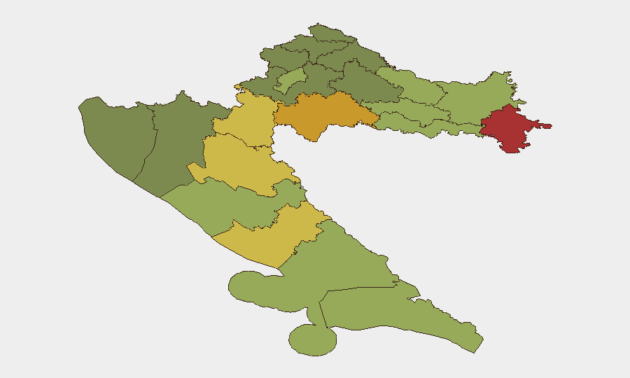
Eastern and inland frontier regions dominate the sub-national risk profile. Vukovar-Srijem, Sisak-Moslavina, and Karlovac counties (composite scores 78, 72, 68 respectively) are the three highest-risk areas, reflecting historical conflict-legacy vulnerabilities, cross-border crime, and limited institutional capacity. The coastal zone—particularly Zadar and Šibenik-Knin counties—shows elevated risk (55–62) driven by property crime, organized smuggling, and tourism-related vulnerabilities. Zagreb (risk 50) remains comparatively stable despite its size and administrative prominence.
How GeoBit Would Assist
Security teams with personnel or assets in Croatia should deploy AOI Monitoring & Early Warning on Vukovar-Srijem and Zadar coastal counties to detect organized crime escalation and cross-border activity. Satellite & Imagery analysis and Environmental & Health monitoring would provide early detection and route-impact assessment of wildfires and transport disruptions, enabling real-time duty-of-care decisions. Multi-language OSINT and X/Twitter feeds can track emerging cyber threats to institutions and supply-chain disruptions affecting corporate operations in Split–Dalmatian and Zagreb regions.
7-Day Outlook
The Omiš wildfire recovery will dominate near-term operational planning; coastal highway restoration and secondary evacuation risks should be monitored through 16–17 Aug. Organized property crime in the Zadar zone is likely to persist, suggesting elevated risk for assets, inventory, and personnel in coastal tourism areas. No indicators suggest escalation to national-level security concern, though seasonal wildfire risk and routine transnational crime should remain in duty-of-care assessments through August.
Highest-Risk Areas — Ranked
| # | State / Region | Risk |
|---|---|---|
| 1 | Vukovar-Srijem County | 78 |
| 2 | Sisak-Moslavina County | 72 |
| 3 | Karlovac County | 68 |
| 4 | Lika-Senj County | 65 |
| 5 | Šibenik-Knin County | 62 |
| 6 | Brod-Posavina County | 58 |
| 7 | Zadar County | 55 |
| 8 | Osijek-Baranja County | 52 |
| 9 | City of Zagreb | 50 |
| 10 | Split-Dalmatia County | 48 |
| 11 | Požega-Slavonia County | 45 |
| 12 | Virovitica-Podravina County | 42 |
Sources
Previous Daily Briefs
A new Croatia brief is written every day — each with its own risk map and downloadable CSV. Here's the last week; use the calendar to go further back.
- August 12, 2026
- August 10, 2026
- August 8, 2026
- August 6, 2026
- August 5, 2026
- August 4, 2026
- August 3, 2026
📅 Browse every day by calendar →
Highlighted days have a brief. Tap a day for that day's map & analysis, or “csv” for that day's dataset ($5).
Atlas — our AI intelligence desk — emails them this snapshot personally. Nothing else, no list.