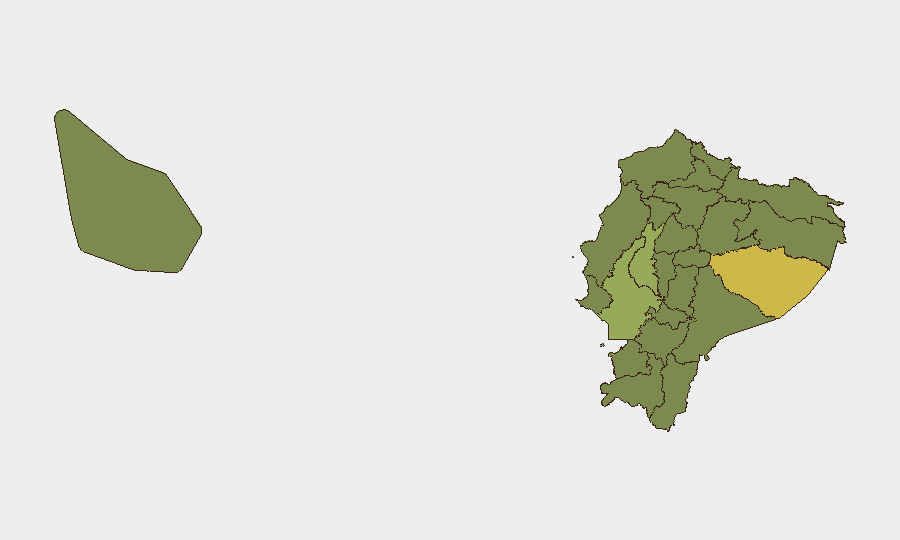
Situation Summary
Ecuador remains under a nationwide state of exception affecting 15+ provinces, with violent crime—particularly targeted killings, armed robbery, and gang confrontations—accelerating across coastal and metropolitan zones. The past 48 hours have registered multiple homicides, a large-scale police intervention operation in Guayaquil (69 interventions, ~35 detainees), and arrest of a criminal group suspected in inter-provincial road violence. Security forces are conducting intensive operations, but the frequency and geographic spread of incidents suggest criminal networks are sustaining operational tempo despite law-enforcement pressure.
Key Developments
- Santa Elena Province, Altos de Olón – 17 July 2026: A man identified as Juan López was shot multiple times and killed in a targeted homicide, consistent with an ongoing wave of coastal assassinations.
- Guayas Province, Yaguachi Canton – 17 July 2026: National Police arrested four adults and isolated one minor following an intelligence-led operation targeting a criminal group responsible for road robberies and violent deaths on inter-provincial routes.
- Guayas Province, Guayaquil (Mapasingue Este) – night of 16–17 July 2026: A man was shot at least four times by two assailants who boarded a public bus (Line 108) near Fe y Alegría school in a targeted attack captured on CCTV; incident caused significant alarm among passengers.
- Guayas Province, Guayaquil metropolitan area (Operativo Apolo 23) – night of 15–16 July 2026: National Police conducted 69 interventions across Guayaquil, Durán, and Samborondón, detaining approximately 35 people and isolating one minor on suspicion of extortion, robbery, and gang activity.
- José Joaquín de Olmedo Airport, Guayaquil – mid-July 2026: Armed violence in airport environs prompted authorities to temporarily restrict access while maintaining flight operations and reinforcing terminal security; heightened controls remain in effect.
- Nationwide State of Exception – updated 17 July 2026: German Foreign Office advisory confirms state of exception across 15 provinces including Pichincha, Guayas, Manabí, Santa Elena, Los Ríos, Orellana, Sucumbíos, and Pastaza, with frequent roadblocks, checkpoints, and risk of demonstrations disrupting inter-city travel.
Highest-Risk Areas
Pastaza (61.6) and Guayas (58.2) are the primary risk drivers, with Guayas—encompassing Guayaquil and coastal corridors—accounting for the majority of recent homicides, armed robberies, and gang-related arrests. Los Ríos Province (40.8) represents a secondary corridor of concern due to inter-provincial robbery networks. Pastaza's elevated score reflects broader Amazonian instability linked to trafficking and resource-conflict dynamics. Together, these three provinces account for the bulk of tracked violent events and active criminal organization presence.
How GeoBit Would Assist
Security teams should employ AOI Monitoring & Early Warning to track hotspots in Guayas, Pastaza, and Los Ríos provinces for sudden spikes in homicides or roadblock activity; Network & Actor Analysis to map criminal organization structure, recruitment patterns, and territorial claims across inter-provincial routes; and Routing & Network Analysis to identify alternative travel corridors and safe passage windows for personnel and asset movement. OSINT fusion (social media, Telegram criminal networks, local news feeds) provides real-time event corroboration and 24–48-hour predictive signals of gang clashes or police operations.
7-Day Outlook
Security operations (Operativo Apolo 23 and similar deployments) will likely continue at current or elevated intensity, with short-term detention and disruption of criminal cells in Guayaquil. However, decentralized gang networks and ongoing cocaine-trafficking competition suggest that homicides and armed robbery will persist or relocate to adjacent provinces. Inter-provincial road corridors remain high-risk; checkpoint delays and demonstrations linked to the state of exception should be anticipated.
Highest-Risk Areas — Ranked
| # | State / Region | Risk |
|---|---|---|
| 1 | Pastaza Province | 61.6 |
| 2 | Guayas Province | 58.2 |
| 3 | Los Ríos Province | 40.8 |
| 4 | Sucumbíos Province | 32 |
| 5 | Pichincha Province | 32 |
| 6 | Orellana Province | 31.6 |
| 7 | Manabí Province | 31.6 |
| 8 | Galápagos | 31.6 |
| 9 | Esmeraldas Province | 31.6 |
| 10 | Carchi Province | 31.6 |
| 11 | Imbabura Province | 31.6 |
| 12 | Santo Domingo de los Tsáchilas Province | 31.6 |
Sources
Previous Daily Briefs
A new Ecuador brief is written every day — each with its own risk map and downloadable CSV. Here's the last week; use the calendar to go further back.
📅 Browse every day by calendar →
Highlighted days have a brief. Tap a day for that day's map & analysis, or “csv” for that day's dataset ($5).
Atlas — our AI intelligence desk — emails them this snapshot personally. Nothing else, no list.