Situation Summary
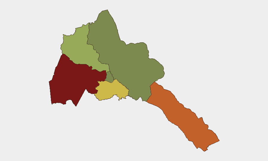
Eritrea remains a low-frequency threat environment (global rank #72, composite score 24) with no tracked internal security incidents as of 23 August 2026. The country's stability is underpinned by centralized state control and limited civil unrest reporting; however, sub-national variation is acute, with Gash-Barka region (risk 92) and Southern Red Sea Region (risk 75) presenting significantly elevated exposure compared to the capital region (Maekel, risk 18). The primary current threat to Eritrean interests lies in maritime exposure, underscored by the 20 August hijacking of the Eritrean-flagged tanker MT Sibu 1 in the Gulf of Aden.
Key Developments
- 20–21 August 2026 · Gulf of Aden (off Yemen) · Maritime Hijacking
Armed pirates seized the Eritrean-flagged oil products tanker MT Sibu 1 approximately 30–136 nautical miles off Yemen's coast near al-Mukalla. The vessel was carrying 20 crew members, including 16 Indian nationals; all crew reported safe as of 23 August, with the vessel subsequently directed toward Somalia's Puntland coast. This incident reflects sustained maritime security risk for Eritrean-flagged shipping and regional sea lanes under Houthi and Somali pirate activity.
- No domestic security incidents recorded in Eritrea proper for 22–23 August 2026.
Live web research and OSINT monitoring confirm absence of documented armed clashes, civil unrest, bombings, or infrastructure failures within Eritrean territory over the last 48 hours; routine travel warnings remain in effect but represent standing advisories, not new escalations.
Highest-Risk Areas
Gash-Barka Region (western border zone, risk 92) and Southern Red Sea Region (risk 75) dominate Eritrea's internal threat profile, likely driven by proximity to Sudan border instability, limited state presence, and historical arms trafficking routes. Debub Region (southern, risk 68) presents secondary concern. By contrast, Maekel Region (comprising Asmara and central administrative areas, risk 18) benefits from intensive security apparatus presence and minimal incident reporting. The concentration of risk in peripheral, under-resourced regions reflects Eritrea's asymmetric security posture and suggests that corporate or humanitarian operations in border zones face substantially higher exposure to armed robbery, smuggling, and cross-border movement than activities in or near the capital.
How GeoBit Would Assist
Teams operating in or responsible for assets in Eritrea should employ GeoBit's AOI Monitoring & Early Warning capability to maintain persistent watch on Gash-Barka and Southern Red Sea regions, triggering alert on cross-border incidents or armed activity. Maritime & Aviation Tracking, coupled with Intel Sweep and multi-language OSINT (targeting regional piracy networks and Houthi signals), will provide continuous visibility into shipping risk and hijacking patterns affecting Eritrean-flagged or -routed cargo. Routing & Network Analysis can identify safer transit corridors and alternative logistics paths to mitigate Gulf of Aden exposure.
7-Day Outlook
Absent major political or military shock, Eritrea's internal security environment is expected to remain stable over the next 7 days. Maritime risk in the Gulf of Aden will persist as the primary exposure for Eritrean commercial interests; the MT Sibu 1 incident underscores the need for continued monitoring of piracy patterns and Houthi activity. Travel advisories and border-zone caution should remain in effect.
Highest-Risk Areas — Ranked
| # | State / Region | Risk |
|---|---|---|
| 1 | Gash-Barka | 92 |
| 2 | Southern Red Sea Region | 75 |
| 3 | Debub Region | 68 |
| 4 | Anseba | 55 |
| 5 | Maekel Region | 18 |
| 6 | Northen Red Sea Region | 0 |
Sources
Previous Daily Briefs
A new Eritrea brief is written every day — each with its own risk map and downloadable CSV. Here's the last week; use the calendar to go further back.
- August 21, 2026
- August 19, 2026
- August 17, 2026
- August 15, 2026
- August 13, 2026
- August 11, 2026
- August 9, 2026
📅 Browse every day by calendar →
Highlighted days have a brief. Tap a day for that day's map & analysis, or “csv” for that day's dataset ($5).
Atlas — our AI intelligence desk — emails them this snapshot personally. Nothing else, no list.