Situation Summary
Israel faces elevated composite security risk (rank #13 globally, score 85) driven by active cross-border military engagement and political-diplomatic pressure. The last 24–48 hours have seen substantive kinetic activity on both the northern (Lebanon) and southern (Gaza) borders, alongside a formal change in force posture under a U.S.-brokered agreement. Domestic governance risks—organized crime infiltration of critical infrastructure tenders—add a secondary layer of concern. The security environment remains volatile but operationally managed; civil aviation remains open.
Key Developments
- Margaliot, northern border (July 22, 07:00–14:00 UTC approx.): Anti-tank missile fired from Lebanese territory struck an agricultural orchard, killing one and wounding seven foreign workers. Reflects ongoing cross-border fire into northern Israel.
- Southern Lebanon, near border (July 22, same timeframe): IDF drone strike killed three Hezbollah operatives in a vehicle, consistent with tit-for-tat response pattern.
- Israel–Lebanon border, three southern Lebanese villages (July 22): IDF began withdrawal from designated "Safe Zone" pilot areas under U.S. agreement; Lebanese Armed Forces assumed control. First operational implementation of this arrangement.
- Hatzerim, southern Israel (July 22, morning): IDF killed Palestinian Islamic Jihad militants suspected of recent rocket attack on the Negev kibbutz.
- Golan Heights / Israel–Syria border (July 22, within 24–48h window): IDF detained Israeli civilians attempting illegal border breach into Syria; part of ongoing pattern of unauthorized crossings.
- National level, multi-agency (July 21–22): Government, police, and state-owned companies held coordinated meeting to address organized crime infiltration of public tenders and critical infrastructure projects.
- National airspace (July 21–22, official statement): Israeli security authorities confirmed no plan to close civil airspace despite heightened regional tensions; flights continue.
Highest-Risk Areas
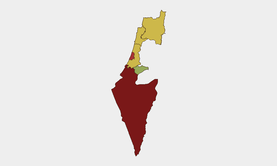
South District (89.6) and Tel Aviv District (78.4) drive the composite threat ranking, reflecting both Gaza-border proximity and density of civilian/economic infrastructure. Southern border rocket and militant activity, combined with critical transportation and industrial hubs in the Tel Aviv metropolitan area, create compounded risk. The North District (62.9) and Haifa (66.4) remain elevated due to Lebanon-border fire, but the Safe Zone withdrawal may modulate tactical intensity in the coming days. Jerusalem District (59.6) carries lower immediate kinetic risk but remains sensitive to political and protest activity linked to broader conflict dynamics.
How GeoBit Would Assist
Security teams should deploy AOI Monitoring & Early Warning on the South District (Negev rocket-impact zones), northern border crossings, and critical infrastructure sites targeted by organized crime. Conflict & Military tracking (battle mapping, force-structure monitoring) would establish baseline understanding of IDF posture changes following the Lebanon Safe Zone withdrawal. Routing & Network Analysis supports alternative journey planning for personnel transiting Tel Aviv, Haifa, and northern regions; Maritime & Aviation tracking confirms continued civil-flight operations while alerting to any shift in that posture. OSINT fusion (cross-referencing social, news, and institutional sources) provides real-time corroboration of incident claims and reduces exposure to disinformation.
7-Day Outlook
The Safe Zone withdrawal implementation may reduce intensity on the northern border in the near term if Hezbollah and Lebanese authorities honor the agreement; however, militant groups' compliance is uncertain. Southern border rocket activity and IDF response cycles are likely to continue. Organized crime governance risks will not resolve within days but warrant sustained attention to procurement and infrastructure vulnerabilities. Airspace closure remains unlikely barring a major escalation event.
Highest-Risk Areas — Ranked
| # | State / Region | Risk |
|---|---|---|
| 1 | South District | 89.6 |
| 2 | Tel-Aviv District | 78.4 |
| 3 | Center District | 67.6 |
| 4 | Haifa District | 66.4 |
| 5 | North District | 62.9 |
| 6 | Jerusalem District | 59.6 |
Sources
Previous Daily Briefs
A new Israel brief is written every day — each with its own risk map and downloadable CSV. Here's the last week; use the calendar to go further back.
📅 Browse every day by calendar →
Highlighted days have a brief. Tap a day for that day's map & analysis, or “csv” for that day's dataset ($5).
Atlas — our AI intelligence desk — emails them this snapshot personally. Nothing else, no list.