Situation Summary
Lebanon remains in a critical security posture following intensified Israeli military operations across the south and center over the past 48 hours, with at least six documented strike incidents and cross-border gunfire affecting civilian areas. The conflict environment is characterized by recurring Hezbollah drone operations, Israeli retaliatory strikes, and Lebanese Army efforts to assert control in buffer zones under US mediation—creating a compressed, volatile operational space with high civilian exposure. Current trajectory indicates sustained cycle of attack-response dynamics rather than de-escalation, with risk concentrated in southern governorates but expanding into Beirut's security apparatus.
Key Developments
- Al-Mansouri, South Lebanon (18 July): Lebanese army vehicle struck an improvised explosive device, killing one soldier and wounding two others; origin of device remains disputed between Lebanese assessment (unknown origin) and Israeli assessment (Hezbollah placement).
- Tebnit, Nabatieh Governorate (18 July): Israeli military executed targeted strike on alleged Hezbollah drone cell following detection of drone operations from the area; part of intensified drone-strike cycle in southern sector over preceding 48 hours.
- Harees, South Lebanon (night of 17–18 July): Israeli forces conducted machine-gun fire on civilian town overnight, forcing residents to appeal to Lebanese army for evacuation; represents direct cross-border fire incident with civilian entrapment risk.
- Kfar Rumman, Nabatieh District (17 July): Israeli drone strike killed motorcyclist and wounded others; incident attributed to response pattern against alleged ceasefire violations.
- South Lebanon multi-location strikes (17–18 July): Confirmed at least 20 Israeli air, drone, and ground fire operations across southern localities, expanding beyond previous buffer-zone parameters and generating formal condemnation.
- Southern Lebanon checkpoint intensification (mid-July, heightened last 48 hours): Lebanese Army has bolstered deployments and checkpoints around US-mediated "pilot zones," affecting movement corridors between south, Beqaa, and Beirut; recent escalation reflects heightened sovereignty assertion amid operational friction.
- Beirut Dahiyeh security operations (mid-July window, recent 48h activity): Lebanese army conducted raids in Beirut's southern suburb with reported incoming fire; multiple arrests made; signals internal security pressure linked to broader conflict environment.
Highest-Risk Areas
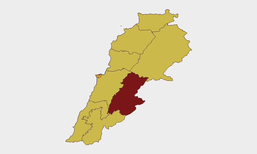
Beqaa Governorate (95.7 risk score) remains the dominant threat node, driven by conventional military activity, cross-border dynamics, and Iranian-aligned actor presence. Nabatieh and South Governorates (68.9 and 65.7 respectively) are experiencing the most acute tactical friction—Israeli strikes, Hezbollah drone operations, and civilian exposure are concentrated here. Beirut Governorate (71.2 score), while second-ranked, reflects internal security operations and potential for collateral spillover from southern operations. Mount Lebanon, Keserwan-Jbeil, North, and Akkar Governorates (all 65–66 range) are elevated but currently secondary to the south-Beqaa corridor.
How GeoBit Would Assist
Intel Sweep and OSINT fusion provide real-time corroboration of incident reports across Lebanese, Israeli, and regional media—critical for distinguishing operational fact from narrative in a high-misinformation environment. AOI Monitoring with alerting on Beqaa, southern governorates, and Beirut checkpoint zones enables duty-of-care teams to detect emerging threats to personnel and asset routes before broad public reporting. Routing & Network Analysis can map safe corridors and alternative journey planning as Lebanese Army checkpoints and strike zones reshape movement patterns across governorates.
7-Day Outlook
Attack-response cycles are expected to continue with 48–72-hour intervals between Hezbollah drone operations and Israeli strikes, maintaining southern Lebanon and Beqaa in active threat status. Movement restrictions via checkpoint expansion and periodic closure of main corridors (Beirut–South–Beqaa trunk routes) should be anticipated. Escalation risk remains elevated if cross-border incidents (such as Harees-type gunfire) cause mass civilian casualties or if Lebanese Army operations in Beirut expand.
Highest-Risk Areas — Ranked
| # | State / Region | Risk |
|---|---|---|
| 1 | Beqaa Governorate | 95.7 |
| 2 | Beirut Governorate | 71.2 |
| 3 | Nabatieh Governorate | 68.9 |
| 4 | Mount Lebanon Governorate | 66.4 |
| 5 | Keserwan-Jbeil Governorate | 66.2 |
| 6 | North Governorate | 65.7 |
| 7 | Akkar Governorate | 65.7 |
| 8 | South Governorate | 65.7 |
| 9 | Baalbek-Hermel Governorate | 65.7 |
Sources
Previous Daily Briefs
A new Lebanon brief is written every day — each with its own risk map and downloadable CSV. Here's the last week; use the calendar to go further back.
📅 Browse every day by calendar →
Highlighted days have a brief. Tap a day for that day's map & analysis, or “csv” for that day's dataset ($5).
Atlas — our AI intelligence desk — emails them this snapshot personally. Nothing else, no list.