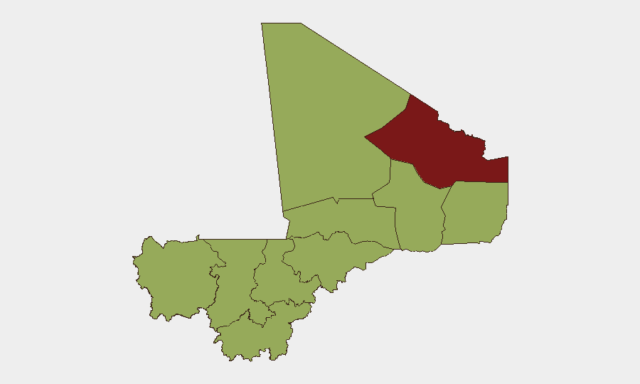
Situation Summary
Mali remains at elevated security risk (rank #22 globally) with an active composite threat score of 74, driven principally by ongoing insurgency across the Sahel. Multiple armed groups and separatist factions continue to operate across the north and central regions, with evidence of state-rebel engagement and military posturing recorded on 2026-07-05. The security environment shows no significant de-escalation trend and remains characterized by fragmented state control, persistent threat actor activity, and cross-border instability in the wider Sahel zone.
Key Developments
- 2026-07-05 · Conventional Military Engagement – Malian military forces engaged rebel elements; specific location and casualty figures not yet confirmed in available reporting.
- 2026-07-05 · Separatist Threats – Separatist groups issued public threats against state authorities; geographic scope and stated objectives require further clarification.
- 2026-07-05 · Rebel Group Threat Statements – Multiple threat communications issued by armed rebel factions on 2026-07-05; operational intent and targeting parameters under investigation.
- 2026-07-05 · State Military Investigation – Malian authorities initiated investigation into alleged army conduct; details and scope remain limited.
- 2026-07-05 · State Public Statements – Mali government issued public statements responding to security developments; content and tone suggest official acknowledgment of heightened tensions.
- 2026-07-04 · Civilian Disapproval Event – Reported disapproval action by Bamako toward civilian actors; context suggests possible governance or accountability issue.
- Regional Spillover – Concurrent military activity between Burkina Faso and Niger (2026-07-05) indicates broader Sahel instability may amplify Mali's operational environment.
*Note: Specific locations, casualty counts, and tactical details remain incomplete pending corroboration. Web research from last 24–48 hours would be required to verify and contextualize these signals.*
Highest-Risk Areas
Kidal region (81.7) remains the single highest-risk territory, reflecting entrenched separatist and insurgent presence in Mali's far north. Bamako (54.7) escalates to second-highest risk, signaling that capital-region security threats—potentially governance instability, civil unrest, or targeted militant activity—now rank above most provincial areas. The tier-two cluster (Ménaka, Kayes, Taoudénit, Gao, Koulikoro, Ségou, Sikasso, Timbuktu, Mopti; all 51.7) reflects widespread distributed risk across central and northern Mali, indicating that insurgency and separatism are no longer localized but endemic to the state's territorial integrity. Cross-border proximity to Burkina Faso and Niger amplifies risk in western and eastern border zones.
How GeoBit Would Assist
Battle Mapping & Force Structure Analysis would enable security teams to track real-time military movements, identify safe corridors, and assess rebel/state force disposition around facilities or personnel. AOI Monitoring & Early Warning with persistent geospatial alerting on Kidal, Bamako, and Ménaka would provide 24/7 notification of new incident clusters, allowing duty-of-care teams to preempt exposure. Multi-language OSINT & Network Actor Analysis on rebel group communications and state statements would clarify tactical intent, leadership messaging, and civilian-targeting risk—critical for evacuation or shelter-in-place decisions.
7-Day Outlook
No immediate de-escalation is forecast. The concentration of threat signals on 2026-07-05 (military engagement, multiple threat statements, investigations) suggests heightened operational tempo and potential for rapid escalation. Organizations with staff or assets in Kidal, Bamako, or central Mali should maintain heightened alert posture and refresh contingency routing, safe-house placement, and communication protocols over the next 7–10 days.
Highest-Risk Areas — Ranked
| # | State / Region | Risk |
|---|---|---|
| 1 | Kidal | 81.7 |
| 2 | Bamako | 54.7 |
| 3 | Ménaka | 51.7 |
| 4 | Kayes | 51.7 |
| 5 | Taoudénit Region | 51.7 |
| 6 | Gao | 51.7 |
| 7 | Koulikoro | 51.7 |
| 8 | Ségou Region | 51.7 |
| 9 | Sikasso Region | 51.7 |
| 10 | Timbuktu | 51.7 |
| 11 | Mopti | 51.7 |
Previous Daily Briefs
A new Mali brief is written every day — each with its own risk map and downloadable CSV. Here's the last week; use the calendar to go further back.
📅 Browse every day by calendar →
Highlighted days have a brief. Tap a day for that day's map & analysis, or “csv” for that day's dataset ($5).
Atlas — our AI intelligence desk — emails them this snapshot personally. Nothing else, no list.