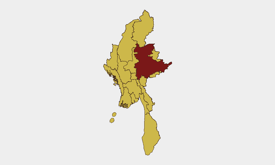
Situation Summary
Myanmar remains in active civil conflict following the February 2021 military coup, with fragmented armed opposition across multiple regions and a humanitarian crisis affecting millions. The national threat ranking (#9 globally, composite score 100) reflects the structural persistence of the conflict rather than an acute escalation in the past 24–48 hours. Current open-source reporting for the immediate period (July 4–6, 2026) is sparse and lacks independent corroboration of specific location-dated incidents. Overall trajectory remains volatile and regionally differentiated, with no credible indicators of imminent nationwide escalation, but sustained risk of localized armed clashes and civilian harm in conflict zones.
Key Developments
Open-source material accessible in the last 24–48 hours does not contain independently corroborated, location-specific security incidents with confirmed July 4–6 dates. Recent specialist assessments (GeoBit Intelligence Myanmar Security Brief, June 30, 2026) explicitly flag that high-confidence dating and precise incident detail for this window remain limited in available sources.
Background context (not current developments): Credible reports from prior weeks reference airstrikes in northern Kachin State and rebel seizure of a border town in Shan State, but exact dates remain pending confirmation and do not meet the 24–48 hour specificity threshold. Social-media claims of airstrikes in Rakhine State lack independent corroboration and precise timing.
Structural factors affecting risk:
- Curfews and communications blackouts remain in effect in major cities (Yangon, Mandalay, Naypyitaw).
- Armed opposition groups maintain control of territory in Shan, Kachin, Sagaing, and Chin regions.
- Flood events are ongoing in multiple regions and may compound displacement and humanitarian access challenges.
Highest-Risk Areas
Shan State (composite risk 100) dominates the sub-national ranking and remains the primary driver of national threat score, reflecting active armed-group presence, cross-border flows, and frequent reports of clashes. Nine additional regions—Tanintharyi, Chin, Sagaing, Kachin, Wa State, Magway, Mandalay, Rakhine, and Ayeyarwady—each register risk score 70, indicating a broad conflict footprint across the country. Yangon and Naypyitaw, despite urban-center status, carry the same risk level, reflecting curfews, blackouts, and potential for civil unrest. The ranking suggests that structural conflict-related risks (armed-group activity, state security operations, communications restrictions, humanitarian strain) are geographically dispersed rather than concentrated, complicating route planning and operational continuity for organizations with multi-site presence.
How GeoBit Would Assist
Security teams should deploy AOI Monitoring & Early Warning on Shan, Kachin, Sagaing, and Chin states to detect real-time changes in armed-group activity and clashes with location precision. Intel Sweep and multi-language OSINT fusion (including X/Telegram monitoring and local-language news aggregation) can fill gaps in open-source incident reporting and provide earlier warning of escalations before mainstream media corroboration. GIS & Spatial Analysis and alternative route/journey planning capabilities enable duty-of-care teams to model safe corridors and contingency movements around active conflict zones and curfew areas.
7-Day Outlook
No acute catalysts for nationwide escalation are evident in the next 7 days. Localized armed clashes and state security operations in Shan, Kachin, and Sagaing are likely to continue at current intensity. Ongoing flooding may disrupt logistics and humanitarian operations, increasing indirect risk to supply chains and personnel dependent on road or river routes. Organizations should maintain heightened monitoring protocols and pre-positioned contingency plans for personnel extraction or asset protection in multi-risk regions.
Highest-Risk Areas — Ranked
| # | State / Region | Risk |
|---|---|---|
| 1 | Shan State | 100 |
| 2 | Tanintharyi Region | 70 |
| 3 | Chin | 70 |
| 4 | Sagaing Region | 70 |
| 5 | Kachin State | 70 |
| 6 | Wa State (Northern Region) | 70 |
| 7 | Magway | 70 |
| 8 | Mandalay | 70 |
| 9 | Rakhine | 70 |
| 10 | Ayeyarwady | 70 |
| 11 | Yangon | 70 |
| 12 | Naypyitaw Union Territory | 70 |
Sources
Previous Daily Briefs
A new Myanmar brief is written every day — each with its own risk map and downloadable CSV. Here's the last week; use the calendar to go further back.
📅 Browse every day by calendar →
Highlighted days have a brief. Tap a day for that day's map & analysis, or “csv” for that day's dataset ($5).
Atlas — our AI intelligence desk — emails them this snapshot personally. Nothing else, no list.