Situation Summary
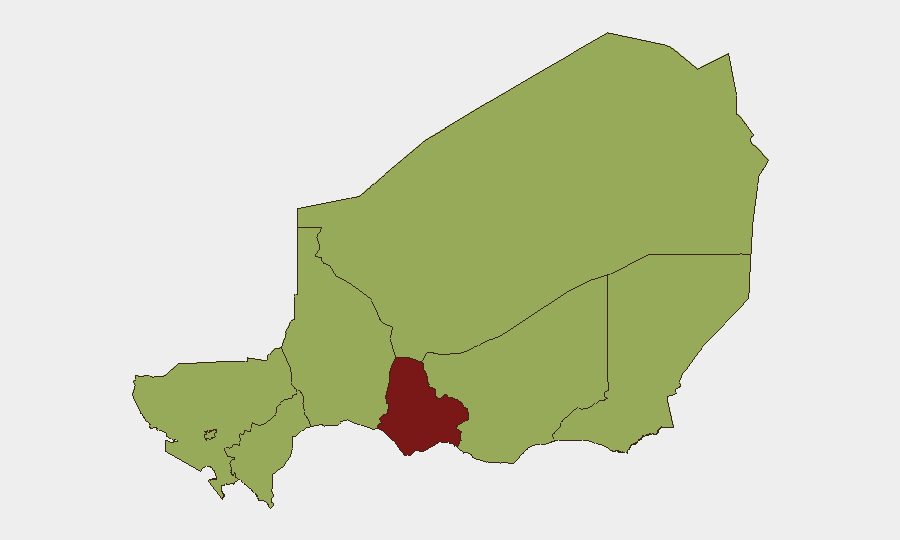
Niger remains in the elevated-risk band globally (#28 overall, composite score 80) with persistent instability across multiple regions. The past 24–48 hours have yielded limited verifiable new security events in available open-source reporting; however, underlying drivers—militant activity, inter-agency friction, and detention operations—remain active. Sub-national risk concentration in Maradi Region (85.7) and five other zones at 55.7+ reflects sustained threat exposure in both urban and remote areas.
Key Developments
Limited New Events (24–48h)
Available open-source reporting does not contain independently verified, dated security incidents for Niger on 8–9 July 2026. GeoBit's event signal logs note:
- 10 July, Conventional Military Operations: Niger military engaged in kidnapper-related incident (location and casualty details not confirmed in available sources).
- 10 July, Arrests: Police detention operations targeting Turkish national and alleged dealer; ongoing multi-day arrest pattern suggests routine law-enforcement activity rather than acute emergency.
- 9 July, Detention Operations: Series of police and operative-led detentions including journalist arrests, indicating possible press-freedom or security-sweep activity.
Context (June–early July)
Analytical reporting on June 2026 operations documents ongoing militant attacks and military losses across the Sahel corridor. This reflects the chronic, rather than acute, threat environment.
*Note: Operational teams requiring real-time incident detail should cross-reference AFP, Reuters, RFI, and Nigerien local media directly for full incident scope and location precision.*
Highest-Risk Areas
Maradi Region stands apart at 85.7 composite risk, substantially higher than seven other regions clustered at 55.7. This disparity reflects either concentrated recent events, demographic vulnerability, or persistent militant presence in Maradi's southern border zones and urban centers. Five other regions—Agadez, Zinder, Diffa, Tillabéri, and Tahoua—maintain equal, elevated baseline risk, indicating broad geographic exposure across the Sahel and north. Niamey and Dosso, though included in the tier, carry slightly lower immediate threat profile but remain operationally significant given capital-city presence and supply-chain criticality.
How GeoBit Would Assist
Security teams with personnel or assets in Niger should deploy AOI Monitoring & Early Warning on Maradi Region and the five Sahel-zone regions to capture detention operations, militant activity, and cross-border incidents with 24–48-hour alert latency. Multi-language OSINT & X/Telegram monitoring (coupled with radio SIGINT in remote areas) will capture local reporting before wire agencies publish. Conflict battle mapping and force-structure tracking enable near real-time visibility into military operations and militant repositioning, essential for routing and evacuation planning.
7-Day Outlook
Maradi Region risk is expected to remain elevated; no major de-escalation indicators are present in current reporting. Arrest and detention operations suggest possible security sweeps or political pressure, which may drive short-term volatility but typically do not cascade into large-scale violence within 7 days. Monitor press-freedom incidents and cross-border infiltration activity (particularly Diffa and Tillabéri) as early warning of broader militant mobilization.
Brief prepared 10 July 2026 | GeoBit Senior Analyst | Confidence: Medium (limited 24–48h event data)
Highest-Risk Areas — Ranked
| # | State / Region | Risk |
|---|---|---|
| 1 | Maradi Region | 85.7 |
| 2 | Agadez Region | 55.7 |
| 3 | Zinder Region | 55.7 |
| 4 | Diffa Region | 55.7 |
| 5 | Tillabéri Region | 55.7 |
| 6 | Niamey | 55.7 |
| 7 | Tahoua Region | 55.7 |
| 8 | Dosso Region | 55.7 |
Sources
Previous Daily Briefs
A new Niger brief is written every day — each with its own risk map and downloadable CSV. Here's the last week; use the calendar to go further back.
📅 Browse every day by calendar →
Highlighted days have a brief. Tap a day for that day's map & analysis, or “csv” for that day's dataset ($5).
Atlas — our AI intelligence desk — emails them this snapshot personally. Nothing else, no list.