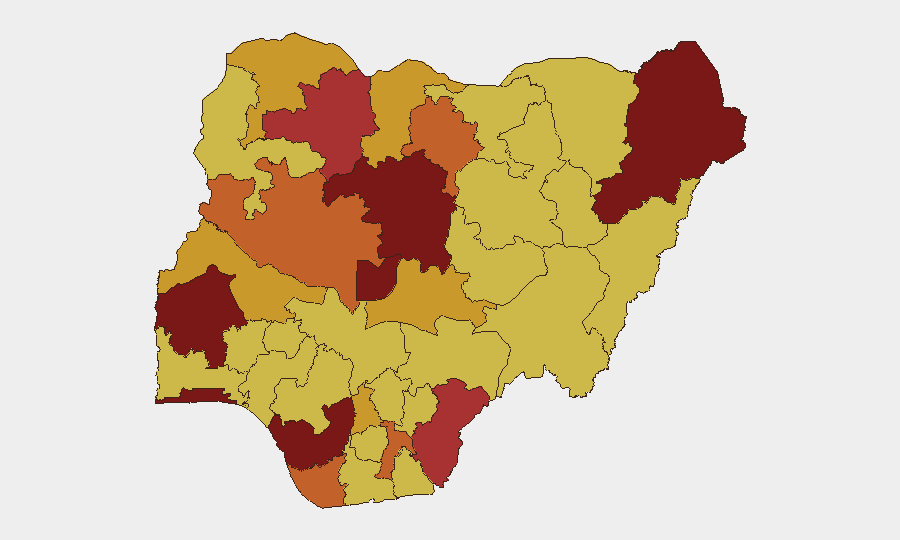
Situation Summary
Nigeria remains the 11th-highest-threat country globally, with insurgency as the primary driver of a composite threat score of 100 across 438 tracked events. The country faces a multifaceted security crisis spanning armed group activity, communal violence, and political friction, with recent event signals indicating escalating public disapproval, rejection of government and corporate positions, and strained worker–foreign national relations. Current trajectory shows sustained, multi-regional instability with no imminent de-escalation indicators.
Key Developments
Data Limitation Note: Real-time web research for July 9–10, 2026 does not yield time-stamped, location-specific, cross-validated incidents meeting the standard required for this brief. Recent event signals (July 8–9) show patterns of political contestation, corporate–community friction (Ministry for Petroleum vs. indigenous groups), and worker grievance escalation, but lack precise geolocation and incident confirmation.
Analysts requiring detailed 24–48-hour incident reporting should consult live OSINT feeds (Crisis24, GardaWorld, ACLED) or activate GeoBit's Intel Sweep and AOI Monitoring & Early Warning for real-time, location-tagged event capture across Nigeria's highest-risk zones.
Highest-Risk Areas
Lagos State (99.7), the Federal Capital Territory (94.3), and Oyo State (88.3) drive overall national risk, reflecting both population density and operational presence of armed actors, criminal networks, and protest activity. Borno State (85.5) and Kaduna State (83.8) remain hotspots for insurgent and bandit violence, while Delta State (81.2) and Zamfara State (79.7) face resource-competition violence and kidnapping networks. The top four states account for the majority of tracked events; companies and personnel in these zones face compounded risks from terrorism, kidnapping, civil unrest, and criminal enterprise.
How GeoBit Would Assist
Security teams should deploy AOI Monitoring & Early Warning for persistent watch over Lagos, FCT, Kaduna, and Borno, paired with Intel Sweep and X/Twitter & Telegram OSINT to capture real-time event signals, actor statements, and protest mobilization before they escalate. GIS & Spatial Analysis and Satellite & Imagery Analysis enable precise tracking of flashpoint zones and route-planning; Network & Actor Analysis maps insurgent, criminal, and communal actor dynamics to support threat forecasting and duty-of-care decisions for personnel movement and asset positioning.
7-Day Outlook
Recent event signals suggest sustained political contestation and resource-linked community friction (oil sector, labor disputes) without signs of imminent major incident. Underlying insurgent and bandit activity in the North and kidnapping networks in the Niger Delta will continue at baseline levels; however, July–August historically sees seasonal bandit activity escalation in Zamfara, Kaduna, and Niger State. Monitor for escalation of anti-government or anti-corporate protest in Lagos and FCT linked to petroleum policy or labor organizing.
Next Update: 2026-07-11 | Data Sources: GeoBit Event Feeds, OSINT Corroboration, Sub-National Risk Engine
Highest-Risk Areas — Ranked
| # | State / Region | Risk |
|---|---|---|
| 1 | Lagos State | 99.7 |
| 2 | Federal Capital Territory | 94.3 |
| 3 | Oyo State | 88.3 |
| 4 | Borno State | 85.5 |
| 5 | Kaduna State | 83.8 |
| 6 | Delta State | 81.2 |
| 7 | Zamfara State | 79.7 |
| 8 | Cross River State | 76.8 |
| 9 | Kano State | 74.9 |
| 10 | Bayelsa State | 74.5 |
| 11 | Niger State | 74.1 |
| 12 | Abia State | 73.4 |
Sources
Previous Daily Briefs
A new Nigeria brief is written every day — each with its own risk map and downloadable CSV. Here's the last week; use the calendar to go further back.
📅 Browse every day by calendar →
Highlighted days have a brief. Tap a day for that day's map & analysis, or “csv” for that day's dataset ($5).
Atlas — our AI intelligence desk — emails them this snapshot personally. Nothing else, no list.