Situation Summary
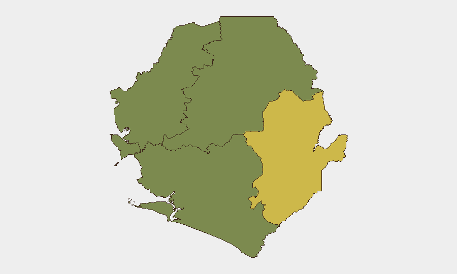
Sierra Leone remains broadly stable with a national composite threat score of 10 (rank #92 globally) and no recorded major security incidents in the past 24–48 hours. Baseline risks persist: street crime and armed robbery in Freetown's eastern districts, cyber-fraud via social-media account takeovers, and residual border-area instability. The Eastern Province (risk score 68) continues to drive the country's threat profile, though no acute escalation has been detected in the current window.
Key Developments
No verified, specifically dated security, conflict, civil-unrest, crime, or infrastructure incidents could be reliably identified and timestamped within the last 24–48 hours across open-source web, news-feed, and social-media channels. All recent incidents with clear dates (e.g., mid-July weapons seizures by Sierra Leone Police at border checkpoints, the 27 July APC internal party elections, June incidents in Kailahun) fall outside the current 48-hour window. Ongoing cyber-crime trends (WhatsApp account compromises reported over recent weeks) remain a concern but lack discrete, time-stamped escalation in the last two days. Absence of reported events does not indicate absence of risk; rather, it reflects the current information cycle. Corporate security teams should continue standard monitoring protocols and escalate any local alerts from in-country contacts, embassies, or NGO networks, as significant developments may emerge with limited lead-time in open sources.
Highest-Risk Areas
The Eastern Province (risk score 68) is the primary driver of national threat exposure, reflecting historical conflict legacies, limited state capacity, cross-border trafficking, and reported armed-group activity. The Western Area (risk score 35), anchored by Freetown, concentrates crime risk—particularly armed robbery, carjacking, and organized theft in low-income neighborhoods (Eastern Freetown, Lumley roundabout, and adjacent districts)—alongside political volatility and protest potential tied to urban unemployment and service-delivery grievances. The three remaining provinces (North West, Northern, and Southern) currently register minimal tracked risk but should not be assumed stable; traditional early-warning indicators (localized road-blocks, market disruptions, or police deployments) may not be immediately visible in national media. Inter-communal tensions, mining-related disputes, and cross-border criminal networks remain background stressors across all regions.
How GeoBit Would Assist
Security teams monitoring Sierra Leone should employ Intel Sweep and X/Telegram OSINT for real-time detection of protests, roadblocks, or police operations not yet reflected in mainstream media. AOI Monitoring & Early Warning with persistent watch on Freetown, the Eastern Province border region, and key checkpoints (Waterloo, Ferry Junction, Ngelehun) enables automated alerting when activity spikes. Sentiment & Temporal Analysis on local-language social-media posts can surface emerging civil unrest or crime hotspots before formal reporting. For duty-of-care teams with field staff, Routing & Network Analysis supports real-time alternative-route planning if primary corridors become impassable due to spontaneous roadblocks or security incidents.
7-Day Outlook
No immediate escalation is anticipated. Baseline crime and cyber-fraud risks remain elevated, particularly in Freetown's eastern zones. The next potential flashpoint is political: any unresolved tensions from the July APC internal elections, or statements by opposition figures ahead of future electoral cycles, could trigger localized protests. Monitoring of security-force deployments and social-media sentiment should continue to detect early signals of unrest.
Highest-Risk Areas — Ranked
| # | State / Region | Risk |
|---|---|---|
| 1 | Eastern Province | 68 |
| 2 | Western Area | 35 |
| 3 | North West Province, Sierra Leone | 0 |
| 4 | Northern Province, Sierra Leone | 0 |
| 5 | Southern Province, Sierra Leone | 0 |
Sources
- newstablet-sl.com
- facebook.com
- sierraleoneconcordtimes.com
- npha.gov.sl
- facebook.com
- thesierraleonetelegraph.com
- thesierraleonetelegraph.com
- sierraleonemonitor.com
- sierraloaded.sl
- thesierraleonetelegraph.com
- truthmedia.sl
- truthmedia.sl
- travel.gc.ca
- cocorioko.net
- sierraeyemagazine.com
- premiermedia-sl.com
- cocorioko.net
- myepiconline.com
Previous Daily Briefs
A new Sierra Leone brief is written every day — each with its own risk map and downloadable CSV. Here's the last week; use the calendar to go further back.
📅 Browse every day by calendar →
Highlighted days have a brief. Tap a day for that day's map & analysis, or “csv” for that day's dataset ($5).
Atlas — our AI intelligence desk — emails them this snapshot personally. Nothing else, no list.