Situation Summary
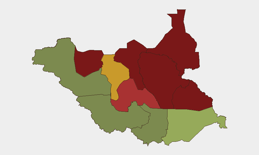
South Sudan remains in a protracted state of fragmentation and insecurity, with composite threat score 65 and concentrated risk in oil-producing northern and eastern states. No verified discrete security incidents have occurred in the 24–48 hours prior to 2026-08-06 00:12 UTC; however, patterns of humanitarian-sector targeting and localized armed clashes persist across Jonglei, Unity, and Upper Nile states. The security environment shows no signs of near-term stabilization, and corporate or NGO operations remain exposed to ambush, intercommunal violence, and supply-chain disruption, particularly outside Central Equatoria.
Key Developments
- No verified incidents occurred in the 24–48 hour window preceding this brief. The most recent attributed event—an ambush of a humanitarian convoy in Duk County, Jonglei State, on 2026-08-03, resulting in five aid worker fatalities—falls outside the current reporting window but underscores persistent targeting of civilian logistics corridors in high-risk states.
- Administrative directive activity (Juba–Nimule Highway). A security-force order to cease truck interceptions for unauthorized revenue collection was reported; however, the occurrence date cannot be verified from available sources and should not be treated as a confirmed current development pending corroboration.
- Jonglei State remains the focal point for armed-group activity and humanitarian-sector incidents, driven by competition over livestock, territory, and resource access among multiple militia factions and pastoralist groups. Attacks on aid convoys reflect deliberate targeting of supply chains rather than incidental conflict spillover.
Highest-Risk Areas
Unity (risk 95), Jonglei (93), and Upper Nile (88) states constitute the primary threat concentration, all located in the oil-rich north and northeast. Risk in these areas stems from overlapping militia control, inter-communal pastoralist conflict, weak state administrative capacity, and geographic remoteness that limits rapid security response. Northern Bahr el Ghazal and Lakes states (82 and 78, respectively) extend this arc of instability westward; by contrast, Central Equatoria (35) and Western Bahr el Ghazal (28) reflect greater security presence and lower armed-group prevalence, making Juba and points south materially safer for corporate operations. Any expansion of operations northward or eastward materially increases exposure.
How GeoBit Would Assist
Corporate security teams should employ AOI Monitoring & Early Warning to track persistent risk signals in Unity and Jonglei, with event-based alerting for armed clashes, supply-route disruptions, and humanitarian-sector incidents. OSINT fusion and multi-language social media intelligence (X, Telegram, local radio SIGINT) provide real-time intelligence on militia movement and intercommunal tension ahead of violence escalation. Routing & Network Analysis enables security and supply-chain teams to model alternative logistics corridors and assess feasibility of movement across high-risk counties, reducing exposure to known ambush zones.
7-Day Outlook
No major escalation drivers are evident in the immediate forecast window, but the underlying security fragmentation—particularly in Jonglei and Unity—remains chronic and volatile. Corporate and humanitarian operations should assume persistent risk of localized armed action, supply-route interdiction, and humanitarian-sector targeting. Duty-of-care teams should maintain heightened posture for personnel and asset movement in the northern states, with contingency planning for rapid mobility or evacuation if intercommunal violence or militia activity accelerates.
Highest-Risk Areas — Ranked
| # | State / Region | Risk |
|---|---|---|
| 1 | Unity | 95 |
| 2 | Jonglei | 93 |
| 3 | Upper Nile | 88 |
| 4 | Greater Pibor Administrative Area | 87 |
| 5 | Northern Bahr el Ghazal | 82 |
| 6 | Lakes | 78 |
| 7 | Warrap | 72 |
| 8 | Ruweng Administrative Area | 68 |
| 9 | Eastern Equatoria | 52 |
| 10 | Western Equatoria | 38 |
| 11 | Central Equatoria | 35 |
| 12 | Western Bahr el Ghazal State | 28 |
Sources
Previous Daily Briefs
A new South Sudan brief is written every day — each with its own risk map and downloadable CSV. Here's the last week; use the calendar to go further back.
📅 Browse every day by calendar →
Highlighted days have a brief. Tap a day for that day's map & analysis, or “csv” for that day's dataset ($5).
Atlas — our AI intelligence desk — emails them this snapshot personally. Nothing else, no list.