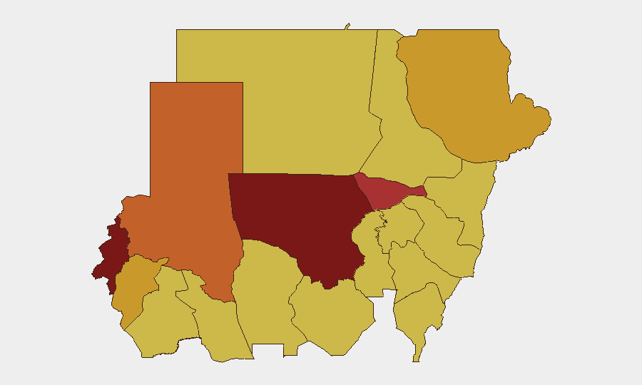
Situation Summary
Sudan remains in active civil conflict with a composite threat score of 100 (rank #7 globally), driven by conventional military operations, sectarian violence, and widespread civilian displacement. The past 48 hours have seen multiple drone strikes on civilian targets in North Kordofan and Khartoum peripheries, resulting in at least 25 confirmed civilian deaths. Arrest and detention of civilians and opposition figures, concurrent with military force operations, signal continued state pressure and instability across transport corridors and civilian movement routes.
Key Developments
- North Kordofan, al-Shaatout town (13 July): Drone strike on a civilian transport vehicle killed 13 civilians, including five women from a single family traveling to a wedding.
- North Kordofan, water facility vicinity (14 July): A second drone strike on a transport vehicle near a water infrastructure site resulted in 2 deaths; location suggests targeting of civilian supply or service movement.
- Khartoum outskirts / west of Omdurman (14 July): Drone strike on a civilian vehicle en route to a wedding killed 10 civilians, including five women. Pattern mirrors North Kordofan strike same day.
- Nationwide (14 July): Multiple arrest/detention events recorded among civilian population and state actors; concurrent human-rights organization disapproval signals ongoing extrajudicial or summary detention practices.
- Cross-border incident (14 July): Small-arms combat reported between Sudan military and Chinese nationals; circumstances and casualties remain unconfirmed.
- Sectarian violence indicator (13 July): Conventional military force event tagged Christian vs. Muslim; geolocation and scale not specified, but indicates religious-communal tension alongside state conflict.
Highest-Risk Areas
North Kordofan State (risk 100) and West Darfur (81.7) remain the epicenter of active kinetic threat, with drone strikes now documenting civilian casualties in routine transport and social gatherings. Khartoum itself scores 78.3—reflecting that the capital and its periphery are no longer sanctuaries; civilians are at elevated risk during movement to outlying areas. The Red Sea, Blue Nile, and eastern states (Kassala, Al Qadarif) all score 70+, indicating either active conflict zones or transit corridors where checkpoint violence, armed robbery, and military operations pose parallel threats. Organizations with staff or assets anywhere in the top five states should assume direct exposure to conventional weapons, detention risk, and drone operations.
How GeoBit Would Assist
Intel Sweep and multi-language OSINT would provide real-time corroboration of unconfirmed cross-border incidents and sectarian violence claims. AOI Monitoring & Early Warning on North Kordofan, West Darfur, and Khartoum periphery—with alert thresholds on drone-strike and arrest-event density—would flag escalation before it affects specific movement routes. Routing & Network Analysis for personnel or supply convoys would identify lower-threat alternatives and timing windows, while satellite & imagery analysis could monitor displacement camps, checkpoint activity, and military concentration near critical infrastructure (water, health, transit hubs).
7-Day Outlook
Drone strikes on civilian transport and gatherings suggest either deliberate targeting or reckless operations in areas previously considered lower-risk. Escalation in arbitrary detention and cross-border armed incidents points to possible involvement of external actors or proxy forces. Risk of further civilian casualties and mobility disruption in North Kordofan and Khartoum approaches remains high through the next 7 days, with secondary risk of wider sectarian mobilization if current military operations intensify in Christian-majority or mixed-population zones.
Highest-Risk Areas — Ranked
| # | State / Region | Risk |
|---|---|---|
| 1 | North Kordofan State | 100 |
| 2 | West Darfur | 81.7 |
| 3 | Al Khartum | 78.3 |
| 4 | North Darfur State | 73 |
| 5 | Central Darfur State | 72.7 |
| 6 | Red Sea State | 72 |
| 7 | Blue Nile | 70 |
| 8 | River Nile State | 70 |
| 9 | Aj Jazira | 70 |
| 10 | Al Qadarif State | 70 |
| 11 | Kassala State | 70 |
| 12 | Sennar State | 70 |
Sources
Previous Daily Briefs
A new Sudan brief is written every day — each with its own risk map and downloadable CSV. Here's the last week; use the calendar to go further back.
📅 Browse every day by calendar →
Highlighted days have a brief. Tap a day for that day's map & analysis, or “csv” for that day's dataset ($5).
Atlas — our AI intelligence desk — emails them this snapshot personally. Nothing else, no list.