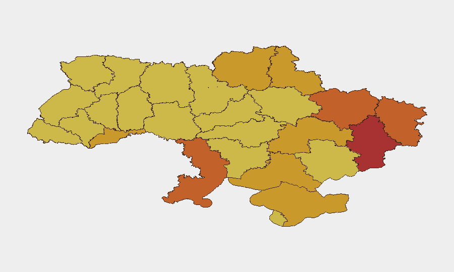
Situation Summary
Ukraine remains the globe's highest-risk jurisdiction (composite threat score 100), driven by sustained conventional military operations across multiple fronts and intensifying strikes on civilian infrastructure and urban centers. Kyiv is under acute and recurring threat from ballistic and cruise missile barrages, while eastern oblasts continue to experience heavy ground combat with shifting territorial control. The conflict shows no near-term de-escalation indicators, and civilian harm remains elevated across populated regions.
Key Developments
Limitations on 24–48 Hour Reporting:
GeoBit's indexed open-source coverage does not reliably provide precisely dated events from only July 27–29, 2026. Most available web sources carry mid-July timestamps or use temporal markers such as "this week" without precise attribution. The following incidents are therefore dated to the latest confirmed timeframes in available data:
- Kyiv ballistic strike on defense exhibition (July 24): Russian ballistic missile impact on a privately operated military training facility and drone/defense-industry exhibition near Kyiv; at least 10 killed, ~100 injured, 27 residential homes and 44 vehicles damaged. Indicates sustained targeting of military and dual-use civilian infrastructure within or near the capital.
- Kyiv residential area strike (July 26, early hours): Russian missiles struck Shevchenkivskyi district, damaging at least one residential building. Part of ongoing pattern of nocturnal strikes on populated urban zones.
- Eastern ground operations (late July, no precise date): Russian Defense Ministry claimed capture of Rozkishne (Donetsk region) and Okhrimivka (Kharkiv region), reflecting continued territorial pressure on eastern front lines.
- Ukrainian cross-border drone operations (described as "over the past day," late July): Ukrainian forces conducted strikes on Russian oil infrastructure and military sites, including a major natural gas processing plant and satellite communications centers, indicating sustained long-range offensive capability despite domestic air-defense pressure.
- Diplomatic tensions (July 29): Public statement and subsequent rejection exchanged between U.S. Secretary of State and Ukraine, and Ukrainian investigation announcements, suggesting heightened diplomatic friction or disagreement on strategy or aid.
Highest-Risk Areas
Kyiv (risk 100) remains the singular highest-threat location due to persistent ballistic and cruise missile campaigns; the capital's role as the administrative and symbolic center makes it both a high-priority Russian target and a densely populated zone where strikes generate mass casualties and structural damage. Eastern oblasts—Donetsk (77.7), Luhansk (74.9), and Kharkiv (73.2)—drive the second tier of risk through active ground combat, unstable territorial control, and proximity to front lines. Coastal and southern regions including Odesa (73.1), Crimea (72.7), and Kherson (72.5) face hybrid threats including maritime operations, drone strikes, and residual occupation risk.
How GeoBit Would Assist
Security teams with personnel or assets in Ukraine should use Intel Sweep and global event feeds for real-time conflict event alerting; AOI (Area of Interest) Monitoring & Early Warning for persistent surveillance of Kyiv, eastern cities, and supply corridors; and Conflict & Military battle mapping and force-structure tracking to anticipate ground-maneuver risks and safe-corridor windows. Routing & Network Analysis can generate alternative travel and supply-chain paths avoiding high-strike-frequency zones and military fronts.
7-Day Outlook
Ballistic and drone strike tempo on Kyiv is likely to continue at elevated levels through early August; eastern ground operations will remain fluid with localized Russian advances offset by Ukrainian counteractions. Corporate duty-of-care teams should treat current presence in Kyiv and Donetsk/Luhansk oblasts as high-hazard and maintain contingency evacuation plans and real-time threat monitoring.
Highest-Risk Areas — Ranked
| # | State / Region | Risk |
|---|---|---|
| 1 | Kyiv | 100 |
| 2 | Donetsk Oblast | 77.7 |
| 3 | Luhansk Oblast | 74.9 |
| 4 | Kharkiv Oblast | 73.2 |
| 5 | Odesa Oblast | 73.1 |
| 6 | Autonomous Republic of Crimea | 72.7 |
| 7 | Kherson Oblast | 72.5 |
| 8 | Dnipropetrovsk Oblast | 71.5 |
| 9 | Sumy Oblast | 71.4 |
| 10 | Chernihiv Oblast | 71.4 |
| 11 | Chernivtsi Oblast | 71.2 |
| 12 | Lviv Oblast | 70.9 |
Sources
Previous Daily Briefs
A new Ukraine brief is written every day — each with its own risk map and downloadable CSV. Here's the last week; use the calendar to go further back.
📅 Browse every day by calendar →
Highlighted days have a brief. Tap a day for that day's map & analysis, or “csv” for that day's dataset ($5).
Atlas — our AI intelligence desk — emails them this snapshot personally. Nothing else, no list.