Situation Summary
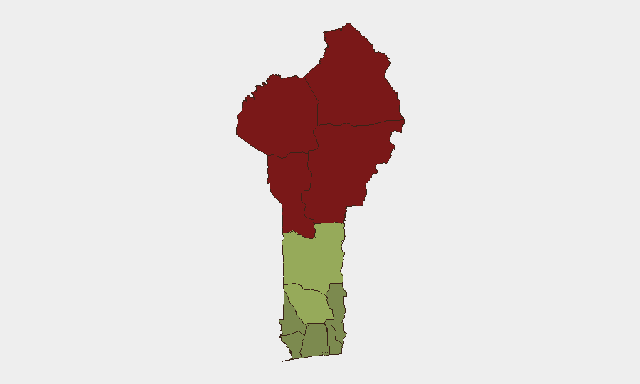
Benin remains at moderate composite threat level (#46 globally, score 37), with insurgency and terrorism as the primary risk drivers. The northern tier—Alibori, Atakora, Donga, and Borgou departments—continues to face elevated threat from armed groups, though no major kinetic events have been recorded in the past 24–48 hours. Recent National Guard deployments signal government stabilization efforts in response to longstanding security pressures; the southern and coastal zones remain materially lower-risk.
Key Developments
- 2026-08-10, nationwide: National Guard increased presence across major cities as part of a public-safety stabilization initiative, indicating government response to heightened security concerns in the medium term.
- 2026-08-15, administrative: Benin government declared a public holiday; no security incident reported.
- No verified security, conflict, civil-unrest, crime, or infrastructure incidents reported in Benin in the last 24–48 hours from available open sources.
Highest-Risk Areas
The northern departments—Alibori (92), Atakora (88), Donga (85), and Borgou (83)—account for the bulk of Benin's threat profile, driven by persistent insurgent activity and porous border zones shared with Burkina Faso and Niger. These areas experience recurring armed-group presence, intercommunal tensions, and limited state capacity. The central band (Zou, Collines, Plateau) shows moderate risk (38–45), while the southern corridor (Ouémé, Atlantique, Littoral) remains substantially lower-risk (22–28), reflecting greater government control and economic density.
How GeoBit Would Assist
AOI Monitoring & Early Warning: Persistent, automated watch over northern departments and border transit corridors would provide real-time alerting if armed-group activity, military operations, or civil unrest spike. Intel Sweep & Conflict Mapping: Multi-language OSINT fusion, Telegram/X monitoring, and radio SIGINT would track cross-border militant communications and force-movement signals ahead of incident reporting. Routing & Network Analysis: Security and logistics teams operating in Benin would use alternative-route planning to avoid high-risk departments and identify secure supply corridors to facilities in Zou, Ouémé, and Littoral zones.
7-Day Outlook
Threat posture is expected to remain steady over the next seven days. The National Guard presence increase may provide short-term stabilization in urban centers, though underlying insurgent pressure in the north is unlikely to diminish materially within this window. Corporate and NGO teams should maintain heightened vigilance protocols in Alibori, Atakora, Donga, and Borgou; southern operations face low-to-moderate risk.
Highest-Risk Areas — Ranked
| # | State / Region | Risk |
|---|---|---|
| 1 | Alibori Department | 92 |
| 2 | Atakora Department | 88 |
| 3 | Donga Department | 85 |
| 4 | Borgou Department | 83 |
| 5 | Zou Department | 45 |
| 6 | Collines Department | 42 |
| 7 | Plateau Department | 38 |
| 8 | Kouffo Department | 35 |
| 9 | Mono Department | 32 |
| 10 | Atlantique Department | 28 |
| 11 | Littoral | 25 |
| 12 | Ouémé Department | 22 |
Sources
Previous Daily Briefs
A new Benin brief is written every day — each with its own risk map and downloadable CSV. Here's the last week; use the calendar to go further back.
- August 14, 2026
- August 12, 2026
- August 11, 2026
- August 10, 2026
- August 9, 2026
- August 8, 2026
- August 7, 2026
📅 Browse every day by calendar →
Highlighted days have a brief. Tap a day for that day's map & analysis, or “csv” for that day's dataset ($5).
Atlas — our AI intelligence desk — emails them this snapshot personally. Nothing else, no list.