Situation Summary
Cameroon remains at composite threat level #26 globally (score 64), with insurgency as the primary driver. No verifiable new security incidents have been publicly reported or corroborated in the last 24–48 hours; however, this reporting gap does not signal reduced risk. Structural fragility persists across the Northwest, Southwest, Centre, and Far North regions, where separatist activity, Boko Haram operations, and communal tensions maintain baseline elevated threat.
Key Developments
No discrete, confirmed security or incident events have been recorded in Cameroon in the last 24–48 hours based on cross-corroboration of open-source media, regional press, and geolocated social-media monitoring.
Prior to this window:
- 2026-07-28 · Reject event (location and parties unspecified in available signals; context under review)
- 2026-07-27 · Arrest/Detain incident linked to Maiduguri–Cameroon border dynamics (Far North escalation pathway)
- 2026-07-26 · Public Statement issued between Nigeria and Cameroon (cross-border diplomatic signal; full context pending)
Background context (not current developments): Operations against separatists in the Northwest (Oku, Kumbo–Ndop corridor), arrests of suspected Boko Haram members in the Far North (Talla Kachi), and attacks in Kousseri and Dabanga date to prior weeks. Security reinforcement at Douala–Bonabéri port and US troop redeployment planning for Maroua represent earlier policy developments.
Highest-Risk Areas
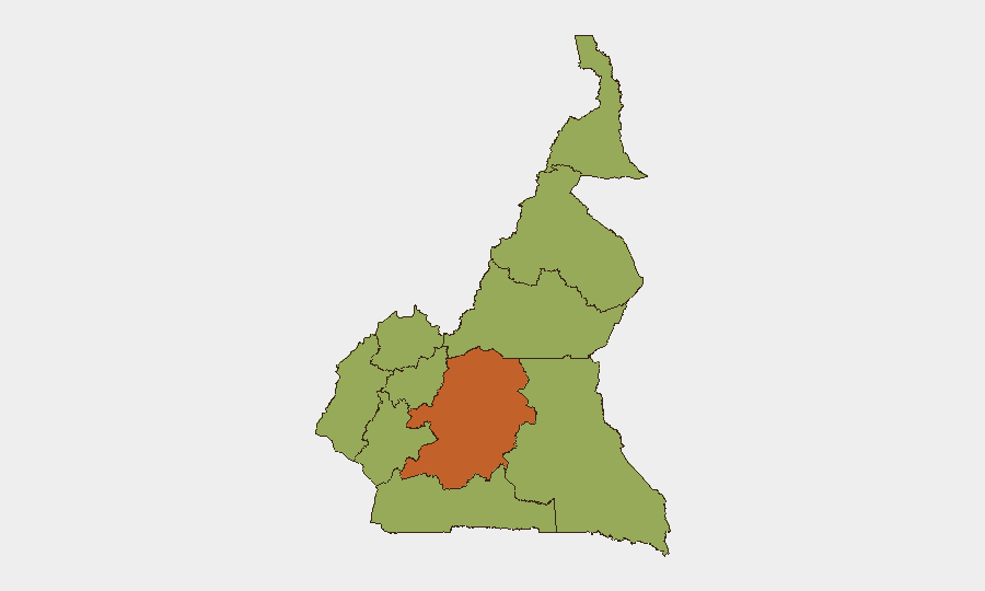
Centre region dominates sub-national risk (74.8), driven by proximity to Yaoundé, administrative density, and spillover from Northwest/Southwest separatist activity. The Northwest, Southwest, West, and Littoral regions cluster at 44.8 risk, reflecting active Ambazonian separatist operations, roadway attacks, and kidnapping pressure. Far North (44.8) remains a Boko Haram and cross-border infiltration corridor, with Maiduguri–Cameroon friction evident in recent arrest and statement signals. Adamawa, South, North, and East regions (all 44.8) face lower but persistent baseline risk from transnational crime, border permeability, and militia activity.
How GeoBit Would Assist
Security and risk teams should deploy AOI (Area-of-Interest) Monitoring & Early Warning on high-risk sub-national zones—particularly the Northwest separatist belt, Centre–Littoral transit corridors, and Far North border zones—to detect onset of escalation before open-source reporting lags. Conflict & Military force-structure tracking, Network & Actor Analysis, and multi-language OSINT fusion (Intel Sweep, X/Telegram, radio SIGINT) will provide real-time visibility into separatist and militant group positioning, statement cycles, and operational intent. Routing & Network Analysis supports alternative journey and supply-chain planning for personnel and assets in Centre, Northwest, and Littoral regions to mitigate checkpoint, ambush, and kidnapping risk.
7-Day Outlook
No imminent escalation is signaled in the 24–48-hour reporting window; however, the absence of confirmed incidents reflects surveillance gaps rather than de-escalation. Baseline separatist and Boko Haram activity in the Northwest, Southwest, and Far North is expected to persist, with sporadic attacks, roadway interdiction, and kidnapping remaining probable in these zones over the next 7 days. Cross-border friction between Nigeria and Cameroon (signaled by 26–27 July statements and arrests) warrants close monitoring of Far North dynamics.
Highest-Risk Areas — Ranked
| # | State / Region | Risk |
|---|---|---|
| 1 | Centre | 74.8 |
| 2 | Northwest | 44.8 |
| 3 | Southwest | 44.8 |
| 4 | West | 44.8 |
| 5 | Littoral | 44.8 |
| 6 | Adamawa | 44.8 |
| 7 | South | 44.8 |
| 8 | Far-North | 44.8 |
| 9 | North | 44.8 |
| 10 | East | 44.8 |
Sources
Previous Daily Briefs
A new Cameroon brief is written every day — each with its own risk map and downloadable CSV. Here's the last week; use the calendar to go further back.
📅 Browse every day by calendar →
Highlighted days have a brief. Tap a day for that day's map & analysis, or “csv” for that day's dataset ($5).
Atlas — our AI intelligence desk — emails them this snapshot personally. Nothing else, no list.