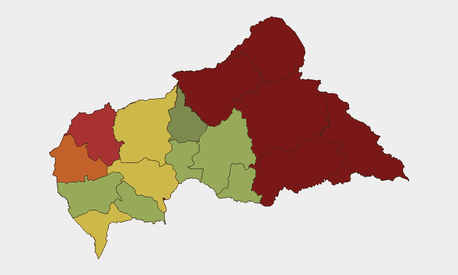
Situation Summary
Central African Republic remains ranked #32 globally in composite threat severity, with a score of 74 reflecting persistent fragmentation across multiple conflict actors, limited state capacity, and humanitarian strain. No discrete security incidents have been recorded in the 24–48 hour window; however, elevated baseline risk persists in the northern and eastern prefectures where armed groups maintain operational presence. The security environment remains volatile but not currently escalating based on available reporting.
Key Developments
No verified, location-specific security incidents have been identified in Central African Republic during the last 24–48 hours from accessible open-source channels. Organizations requiring real-time incident confirmation are advised to cross-reference:
- MINUSCA (UN Multidisciplinary Integrated Stabilization Mission) official press releases and situation reports
- International news wires with dedicated Africa bureaus (Reuters, AFP, AP)
- ACLED (Armed Conflict Location & Event Data) and INSO (International NGO Safety Organisation) daily alerts
- Official travel advisories from home governments and regional bodies
Highest-Risk Areas
Vakaga (risk 95) and Bamingui-Bangoran (risk 92) in the north, and Haute-Kotto (risk 88) and Haut-Mbomou (risk 85) in the east, drive the country's composite threat profile. These regions exhibit chronically weak state presence, porous borders facilitating cross-border armed group movement, and limited access for humanitarian and security monitoring. Bangui (risk 78), the capital, ranks seventh in sub-national risk, reflecting urban crime, occasional inter-communal tension, and political fragility. Organizations with personnel or assets in prefectures ranked above 75 should maintain heightened awareness protocols and contingency routing capacity.
How GeoBit Would Assist
A corporate or NGO security team operating in or transiting CAR would deploy AOI Monitoring & Early Warning to establish persistent watch on high-risk prefectures (Vakaga, Bamingui-Bangoran, Haute-Kotto) with automated alerting for armed group movement, clashes, or blockades. Routing & Network Analysis would generate real-time alternative journey plans avoiding choke points and conflict hotspots, while Intel Sweep, X/Twitter OSINT, and multi-language search would surface emerging threats—protest activity, roadblocks, security force repositioning—often reported first on social platforms or local radio before formal wires. Satellite & Imagery analysis and GIS & Spatial Analysis would enable ground-truth verification of reported incidents and identification of safe corridors and gathering areas.
7-Day Outlook
The short-term security trajectory is expected to remain stable absent unexpected political or military shocks. Seasonal factors (dry season logistics, harvest patterns) and ongoing MINUSCA presence constrain large-scale escalation, though localized clashes and crime remain routine in ungoverned areas. Organizations should maintain standard risk monitoring and duty-of-care protocols; no imminent national-level crisis is signaled in current reporting.
CONFIDENCE LEVEL: Moderate. This brief reflects available open-source data as of the timestamp. For operational decisions, consult specialized regional security networks, MINUSCA updates, and host-government advisories.
Highest-Risk Areas — Ranked
| # | State / Region | Risk |
|---|---|---|
| 1 | Vakaga | 95 |
| 2 | Bamingui-Bangoran | 92 |
| 3 | Haute-Kotto | 88 |
| 4 | Haut-Mbomou | 85 |
| 5 | Mbomou | 82 |
| 6 | Ouham-Pendé | 79 |
| 7 | Bangui | 78 |
| 8 | Nana-Mambéré | 75 |
| 9 | Sangha-Mbaéré | 68 |
| 10 | Ouham | 65 |
| 11 | Ombella-M'Poko | 62 |
| 12 | Kémo | 58 |
Sources
Previous Daily Briefs
A new Central African Republic brief is written every day — each with its own risk map and downloadable CSV. Here's the last week; use the calendar to go further back.
📅 Browse every day by calendar →
Highlighted days have a brief. Tap a day for that day's map & analysis, or “csv” for that day's dataset ($5).
Atlas — our AI intelligence desk — emails them this snapshot personally. Nothing else, no list.