Situation Summary
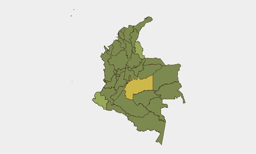
Colombia faces an acute security inflection marked by coordinated explosive attacks against military and police infrastructure, armed-group clashes in rural zones, and mounting protest risk around the 20 July Congressional session and 7 August presidential handover. The past 24 hours have seen a marked escalation in ELN and Clan del Golfo violence, particularly in Norte de Santander and Cauca, concurrent with political tension in urban centers. The composite national threat score of 61 places Colombia at #38 globally, but sub-national variance is extreme—Meta Department (67.4) and the Capital District (49.4) face substantially divergent risk profiles, with border regions and rural conflict zones concentrated in the top-risk tier.
Key Developments
- Tibú, Norte de Santander (18 July 2026): Explosive-laden drones and a car bomb targeted Batallón de Selva No. 50 military base; a subsequent drone strike on Tibú airport offices injured three security personnel. Attacks attributed to ELN.
- Tibú airport, Norte de Santander (evening, 18 July 2026): ELN drone strike on civil aviation facilities caused infrastructure damage and personnel injury, indicating deliberate targeting of transport hubs and military presence near the Venezuelan border.
- Tame (Betoyes), Arauca (18 July 2026): Explosive attack on police substation killed two officers and one civilian; nine police and one soldier injured. Reflects sustained insurgent pressure on law-enforcement nodes in remote Arauca.
- Cauca Department (18 July 2026): Colombian Army thwarted an attempted violent disturbance (*asonada*), detaining a minor and responding to four civilian injuries. Underscores civil-unrest and armed-group competition in southwestern region.
- Jericó, Antioquia (18 July 2026): Armed clashes between Army (Cacique Nutibara Battalion, Fourth Brigade) and alleged Clan del Golfo operatives in rural zone, signaling persistent criminal-insurgent activity and secondary-road risk.
- Quibdó–Carmen de Atrato road, Chocó (released 18 July 2026): 39 people, including a minor, abducted by ELN on 14 July were freed following military rescue operation. Release confirms ELN kidnapping operations and road-transit vulnerability in Chocó.
- Bogotá and major cities (18–19 July 2026): Official travel advisories warn of heightened protest, roadblock, and potential violent-unrest risk around Congressional opening (20 July) and presidential transition (7 August), with demonstrated disruption in traffic and public assembly spaces.
Highest-Risk Areas
Meta Department (67.4) and Capital District (49.4) lead the risk ranking, with Meta's elevation driven by coca-cultivation zones, ELN and dissident-FARC activity, and Amazon-border instability. Norte de Santander (40.8), Nariño (46.5), and Cauca (39.5) form a southwestern and border corridor where ELN explosive operations, trafficking networks, and armed-group territorial competition create persistent kinetic and kidnapping risk. Antioquia (38.1) and Valle del Cauca (37.8) remain elevated due to Clan del Golfo presence and urban-criminal overlap. Chocó and Arauca, though slightly lower on the composite index, have demonstrated acute tactical violence in the past 48 hours and warrant elevated monitoring for corporate and NGO personnel in those regions.
How GeoBit Would Assist
Intel Sweep and multi-language OSINT (X, Telegram, local news feeds) would provide real-time alerting on ELN and Clan del Golfo operations, drone-attack timelines, and protest mobilization in Bogotá. AOI Monitoring with persistent alerting on Tibú, Tame, and other hotspots would flag escalation patterns and road-closure risk before impact on supply chains or personnel movement. Routing & Network Analysis would enable security teams to model alternate transit corridors around Quibdó, Cauca, and Arauca and assess checkpoint and ambush exposure on secondary roads.
7-Day Outlook
The 20 July Congressional convening and concurrent ELN operational tempo suggest sustained urban protest risk and rural armed-group activity through early August. Explosive-drone and IED attacks are likely to continue in Norte de Santander and Arauca; kidnapping risk remains elevated on rural corridors in Chocó, Cauca, and Meta. Contingency planning for urban disruption in Bogotá and major cities and reassessment of field-team travel to border and coca-cultivation zones are warranted.
Highest-Risk Areas — Ranked
| # | State / Region | Risk |
|---|---|---|
| 1 | Meta Department | 67.4 |
| 2 | Capital District | 49.4 |
| 3 | Nariño | 46.5 |
| 4 | Norte de Santander Department | 40.8 |
| 5 | Cauca | 39.5 |
| 6 | Atlántico Department | 38.9 |
| 7 | Caquetá Department | 38.8 |
| 8 | Amazonas | 38.6 |
| 9 | Santander Department | 38.5 |
| 10 | Antioquia Department | 38.1 |
| 11 | Valle del Cauca Department | 37.8 |
| 12 | Bolívar Department | 37.7 |
Sources
Previous Daily Briefs
A new Colombia brief is written every day — each with its own risk map and downloadable CSV. Here's the last week; use the calendar to go further back.
📅 Browse every day by calendar →
Highlighted days have a brief. Tap a day for that day's map & analysis, or “csv” for that day's dataset ($5).
Atlas — our AI intelligence desk — emails them this snapshot personally. Nothing else, no list.