Situation Summary
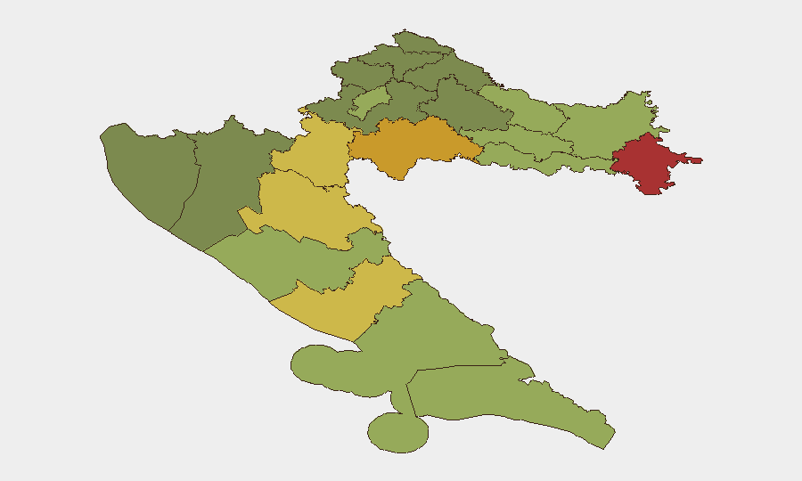
Croatia remains a low-threat environment (global rank #145) with no tracked security incidents. The primary near-term operational risk is active large-scale wildfires on the Dalmatian coast (Omiš area and Pelješac Peninsula as of 2026-08-14 to 2026-08-15) that have triggered mass evacuations, injuries, and transport disruptions. Sub-national risk is concentrated in the eastern border counties (Vukovar-Srijem, Sisak-Moslavina, Karlovac), driven by legacy instability and proximity to historical conflict zones; the western and southern coastal regions currently face acute but temporary fire-related hazards. The overall security trajectory remains stable absent new developments.
Key Developments
- Omiš wildfire, Dalmatian coast — 2026-08-14 to 2026-08-15: A major wildfire near Omiš and Lokva Rogoznica forced evacuation of more than 1,000 residents and tourists. Reuters reporting documented 36 injuries. Evacuation centers were opened in Omiš, Dugi Rat, Makarska, and Split.
- Omiš bypass (DC553) closure — 2026-08-15: The main road bypass around Omiš was closed due to fire proximity, creating significant traffic disruption for travelers in the Split-Dalmatia region.
- Pelješac Peninsula wildfire — 2026-08-14 to 2026-08-15: A separate fire on Pelješac remained partially contained. One-lane alternating traffic was imposed on DC414 (between Prizdrina and Potomje) and local roads (Kuna Pelješka–Pijavičine).
- Homes threatened and infrastructure damage — 2026-08-14: Social media reports indicated the Borak area and central Omiš faced active fire spread and structural threat; specific casualty and damage counts remain preliminary pending official consolidated reporting.
- Ongoing displacement and emergency response — 2026-08-15: Multiple evacuation centers remained operational, indicating sustained displacement and continued emergency services deployment in the region.
Highest-Risk Areas
The eastern border counties—Vukovar-Srijem (78), Sisak-Moslavina (72), and Karlovac (68)—drive the national risk profile. These areas reflect residual tensions, infrastructure gaps, and proximity to the Serbia–Croatia border and legacy conflict zones; security incidents in this corridor remain the primary chronic concern for long-term operations. Split-Dalmatia and Zadar counties (48 and 55 respectively) are currently elevated due to the active wildfire threat, creating near-term duty-of-care exposure for tourism, transport, and hospitality operations. Zagreb (50) remains a standard metropolitan risk baseline.
How GeoBit Would Assist
AOI Monitoring & Early Warning would provide persistent watch on the Omiš and Pelješac fire zones with real-time alerting on perimeter spread, evacuation zone expansion, and road closure updates—critical for staff safety and asset routing. Routing & Network Analysis would enable rapid alternative-journey planning around the Omiš bypass and Pelješac traffic restrictions to protect supply-chain and personnel mobility. Multi-source OSINT fusion (X, Telegram, local news, satellite imagery analysis) would consolidate fragmentary social-media reports, official updates, and transport data into a unified operational picture for duty-of-care decision-making. For the longer-term eastern-border risk, Conflict & Military and Network & Actor Analysis capabilities would track low-level cross-border activity and organized-crime networks in the Vukovar-Srijem and Sisak-Moslavina zone.
7-Day Outlook
The Omiš and Pelješac fires are expected to remain the dominant operational concern through 2026-08-16 to 2026-08-18, with suppression and evacuation-center operations likely ongoing. Road reopenings may occur in phases; travel plans should remain flexible and monitor official Croatian transport updates. No new security or civil-unrest signals are forecast; seasonal wildfire risk will persist through August in the southern coastal belt.
Highest-Risk Areas — Ranked
| # | State / Region | Risk |
|---|---|---|
| 1 | Vukovar-Srijem County | 78 |
| 2 | Sisak-Moslavina County | 72 |
| 3 | Karlovac County | 68 |
| 4 | Lika-Senj County | 65 |
| 5 | Šibenik-Knin County | 62 |
| 6 | Brod-Posavina County | 58 |
| 7 | Zadar County | 55 |
| 8 | Osijek-Baranja County | 52 |
| 9 | City of Zagreb | 50 |
| 10 | Split-Dalmatia County | 48 |
| 11 | Požega-Slavonia County | 45 |
| 12 | Virovitica-Podravina County | 42 |
Sources
Previous Daily Briefs
A new Croatia brief is written every day — each with its own risk map and downloadable CSV. Here's the last week; use the calendar to go further back.
- August 14, 2026
- August 12, 2026
- August 10, 2026
- August 8, 2026
- August 6, 2026
- August 5, 2026
- August 4, 2026
📅 Browse every day by calendar →
Highlighted days have a brief. Tap a day for that day's map & analysis, or “csv” for that day's dataset ($5).
Atlas — our AI intelligence desk — emails them this snapshot personally. Nothing else, no list.