Situation Summary
Eritrea remains a low-frequency security environment globally (rank #72; composite threat score 24), with no confirmed acute incidents inside the country in the last 24–48 hours. However, underlying structural risks persist: Ethiopia–Eritrea border tensions are heightened, with recent analytical reporting citing Eritrean support for armed actors in Ethiopia and aggressive military posturing near the shared frontier. Maritime exposure also remains relevant through Eritrean-flagged vessels operating in the Gulf of Aden, where Somali piracy continues to pose a direct threat to nationals and assets at sea.
Key Developments
- No clearly documented, multi-sourced security or unrest incidents confirmed inside Eritrea for 24–25 August 2026. Open web results do not show specific dated attacks, clashes, arrests, or infrastructure incidents on Eritrean soil in this window. Information control in Eritrea means delayed or absent public reporting of security events is routine.
- MT Sibu 1 (Eritrean-flagged tanker) remains subject of ongoing maritime incident reporting following hijacking by six armed Somali pirates on 20 August off Yemen; 20-person crew (mostly Indian nationals) status as of 25 August remains under reporting as of this brief's composition. This falls outside the 24–48-hour window but reflects active maritime risk to Eritrean-flagged commerce.
- Ethiopia–Eritrea border tensions described as elevated in recent analytical assessments (last 3–5 days), with allegations of Eritrean military support for armed actors inside Ethiopia and military positioning near the international boundary. No specific dated clashes or incursions confirmed inside Eritrea in the last 48 hours; assessments are trend-based rather than incident-specific.
Highest-Risk Areas
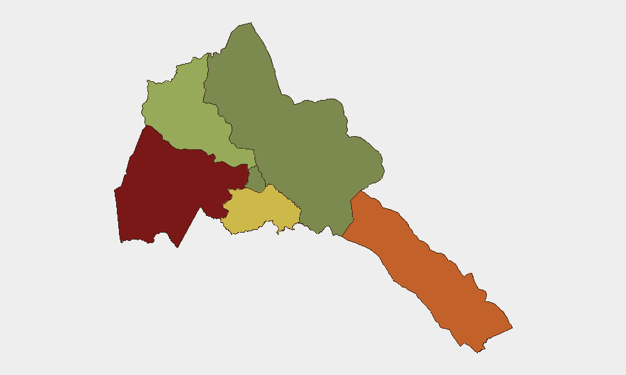
Gash-Barka (score 92) and Southern Red Sea Region (score 75) remain the highest-risk sub-national zones, driven by proximity to Ethiopia and Sudan respectively, historical cross-border movement of armed actors, and limited state security presence in remote areas. Debub Region (score 68) carries elevated risk from similar border-adjacent dynamics. By contrast, Maekel Region (score 18), which includes the capital Asmara, remains relatively low-risk, reflecting greater central security apparatus density and international diplomatic presence. The Northern Red Sea Region (score 0) shows minimal tracked risk signals.
How GeoBit Would Assist
Organizations with personnel or assets in Eritrea should employ AOI Monitoring & Early Warning on high-risk border zones (Gash-Barka, Southern Red Sea) to detect cross-border movement, military activity, or displacement patterns before they affect operations. OSINT fusion and multi-language search across Tigrinya, Arabic, and English sources, combined with sentiment & temporal analysis, can surface delayed or controlled-media reporting of security incidents that open sources may not surface promptly. Maritime & Aviation tracking provides real-time visibility of Eritrean-flagged vessels and aircraft movements, reducing exposure to piracy or mid-sea incidents affecting supply chains or personnel mobility.
7-Day Outlook
No acute security escalation inside Eritrea is anticipated in the immediate 7-day window based on current open-source signals. However, Ethiopia–Eritrea border tensions will likely remain elevated, and any significant cross-border incident (military clash, refugee influx, or armed-group movement into Eritrea) could rapidly degrade the security picture, particularly in Gash-Barka. Personnel and operations in border regions should maintain heightened situational awareness and contingency readiness.
Highest-Risk Areas — Ranked
| # | State / Region | Risk |
|---|---|---|
| 1 | Gash-Barka | 92 |
| 2 | Southern Red Sea Region | 75 |
| 3 | Debub Region | 68 |
| 4 | Anseba | 55 |
| 5 | Maekel Region | 18 |
| 6 | Northen Red Sea Region | 0 |
Sources
Previous Daily Briefs
A new Eritrea brief is written every day — each with its own risk map and downloadable CSV. Here's the last week; use the calendar to go further back.
- August 23, 2026
- August 21, 2026
- August 19, 2026
- August 17, 2026
- August 15, 2026
- August 13, 2026
- August 11, 2026
📅 Browse every day by calendar →
Highlighted days have a brief. Tap a day for that day's map & analysis, or “csv” for that day's dataset ($5).
Atlas — our AI intelligence desk — emails them this snapshot personally. Nothing else, no list.