Situation Summary
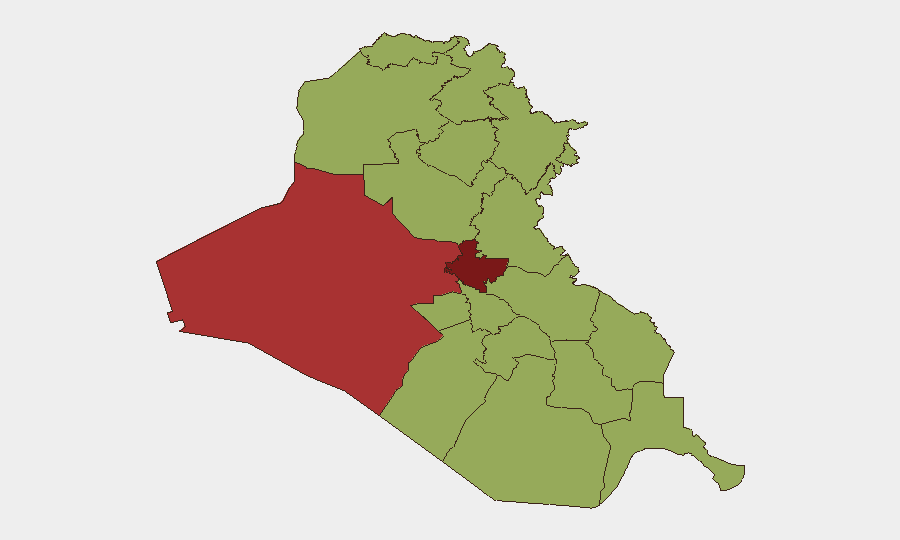
Iraq remains the 17th-highest-threat country globally, with an composite threat score of 82 driven primarily by ongoing insurgent activity across 276 tracked events. Baghdad Governorate carries the highest sub-national risk (87.5), reflecting sustained pressure from armed groups operating in the capital and surrounding regions. Signal activity over the past 72 hours indicates continued friction involving international actors, Iraqi security forces, and non-state armed groups, though the operational tempo and geographic distribution of incidents require real-time verification against local news feeds.
Key Developments
Data Limitation Notice: Available search results do not contain discrete, time-stamped incidents with verified locations for July 12–14, 2026. The most recent event signals in the GeoBit database are flagged for July 11–13 (arrest, threats, military operations, property seizure, and disapproval statements), but specific geographic details and confirmed casualty or operational impact data are not present in current public sources.
To support duty-of-care decisions for personnel or assets in Iraq, GeoBit recommends immediate tasking of live OSINT feeds—Iraqi Security Media Cell posts, Rudaw/Kurdistan24/Shafaq News reporting, and wire service alerts filtered to Iraq—to identify:
- IED or direct-fire attacks by date and district
- Militia rocket or drone launches (origin and target)
- Civil unrest or protest activity in major cities
- Infrastructure disruptions (airports, pipelines, power grid)
- Targeted kidnappings or assassinations
Without those feeds, operational risk assessment for the last 48 hours would rest on inference from the 72-hour signal trend rather than confirmed incident data.
Highest-Risk Areas
Baghdad Governorate (87.5) dominates risk, reflecting the concentration of national institutions, sectarian tensions, and high-profile militant targeting. Al-Anbar (78.1)—encompassing Ramadi, Fallujah, and the Syrian border zone—remains a persistent sanctuary for remnant Islamic State cells and Sunni insurgent groups. Saladin, Babil, Wasit, and the southern governorates (Dhi Qar, Al-Muthanna, Maysan, Al-Basra, Al-Najaf) cluster at 57.5–58.9, indicating distributed but lower-intensity threat activity; however, volatility in Saladin (oil and infrastructure targets) and recurring sectarian friction in the south warrant continuous monitoring. The Kurdistan region (Erbil, 57.5) reflects cross-border Turkish and Iranian military activity, not internal conflict.
How GeoBit Would Assist
AOI Monitoring & Early Warning on Baghdad, Al-Anbar, and Saladin would provide persistent alerting for attack indicators, protest mobilization, and checkpoints affecting staff movement. OSINT fusion (X/Twitter, Telegram, local news aggregation) and multi-language search would enable 24/7 tracking of Iraqi Security Media Cell, militia public statements, and real-time incident reporting without latency. Routing & Network Analysis would support alternative-route planning for convoys and supply chains in response to flash incidents (IED zones, roadblocks, sectarian cordons). Conflict & Military force-structure tracking would clarify which armed groups are active in each governorate and their operational posture.
7-Day Outlook
Threat levels are expected to remain elevated across Baghdad and Al-Anbar through mid-to-late July, with seasonal summer increases in militant and criminal activity typical for the period. Regional Iran–U.S. tensions and cross-border Turkish/Iranian strikes in the north may elevate collateral risk for international operations near the Kurdistan border. Security teams should maintain heightened situational awareness, particularly for supply-chain disruptions and checkpoint delays, and refresh contingency protocols for rapid evacuation or in-place sheltering.
Highest-Risk Areas — Ranked
| # | State / Region | Risk |
|---|---|---|
| 1 | Baghdad Governorate | 87.5 |
| 2 | Al-Anbar Governorate | 78.1 |
| 3 | Saladin Governorate | 58.9 |
| 4 | Babil Governorate | 57.5 |
| 5 | Wasit Governorate | 57.5 |
| 6 | Al-Qadisiyah Governorate | 57.5 |
| 7 | Dhi Qar Governorate | 57.5 |
| 8 | Al-Muthanna Governorate | 57.5 |
| 9 | Maysan Governorate | 57.5 |
| 10 | Al-Basra Governorate | 57.5 |
| 11 | Al-Najaf Governorate | 57.5 |
| 12 | Erbil Governorate | 57.5 |
Sources
Previous Daily Briefs
A new Iraq brief is written every day — each with its own risk map and downloadable CSV. Here's the last week; use the calendar to go further back.
📅 Browse every day by calendar →
Highlighted days have a brief. Tap a day for that day's map & analysis, or “csv” for that day's dataset ($5).
Atlas — our AI intelligence desk — emails them this snapshot personally. Nothing else, no list.