Situation Summary
Lebanon remains at elevated threat (rank #16 globally, composite score 75) amid active Israeli military operations in the south and implementation of a US-backed ceasefire framework involving Lebanese Army deployment to pilot zones. The security environment is marked by simultaneous processes: Israeli airstrikes and ground activity continue across southern governorates, while Lebanese authorities attempt to assume control in designated areas under new trilateral arrangements. The trajectory is volatile and dependent on adherence to the nascent ceasefire implementation timeline and Israeli withdrawal compliance.
Key Developments
- Froun, Srifa, Zawtar al-Gharbiya (South Lebanon) – 20 July 2026: Lebanese Armed Forces began formal pilot-zone security operations under a US-backed trilateral framework, marking the first on-the-ground implementation of the ceasefire agreement reached in Rome. This represents a structural shift in local security control from Israeli/Hezbollah influence toward state authority.
- Multiple villages, Tyre and Nabatieh districts (South Lebanon) – 19–20 July 2026: Israeli forces conducted continued cross-border airstrikes and artillery barrages across southern Lebanon despite ceasefire arrangements, including drone strikes on multiple villages. Attacks contributed to ongoing infrastructure damage and civilian displacement in high-risk southern governorates.
- Mansouri, Tyre district (South Lebanon) – 18 July 2026: A Lebanese Army vehicle struck an explosive device, killing one soldier and wounding two others. Israeli military attributed the device to Hezbollah; Lebanese Army launched investigation. Incident underscores contamination of routes and elevated risk for military and civilian movement in southern sectors.
- Southern Lebanon general front (Nabatieh, South, Baalbek-Hermel) – 18–20 July 2026: Lebanese Health Ministry and security briefings document continued Israeli airstrikes, artillery, drone activity, and controlled demolitions across multiple villages, with cumulative casualties and extensive infrastructure damage recorded.
- Washington, D.C. / Southern Lebanon – 20 July 2026: Lebanese President Joseph Aoun's visit to Washington directly correlates with activation of southern pilot-zone operations, indicating active US diplomatic coordination of the security transition and Israeli withdrawal timeline.
Highest-Risk Areas
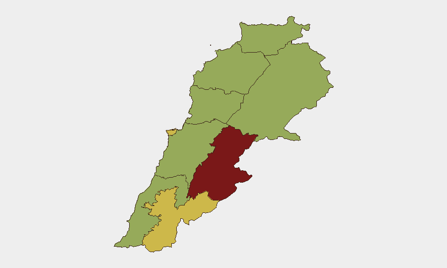
Beqaa Governorate (risk 82.8) ranks significantly above all other regions and is the primary driver of national threat score, reflecting ongoing Iranian military presence and cross-border activity. The three southern governorates—Nabatieh (60.9), South (53.4)—and Baalbek-Hermel (54.6) form a contiguous high-risk corridor spanning active Israeli operations, Hezbollah infrastructure, and now transitional Lebanese Army control. Beirut (61.3) remains elevated due to political instability and protest activity. The concentration of events and ongoing military operations in the south and Beqaa means personnel and asset exposure in these regions carries substantially higher incident probability than northern or Mount Lebanon areas.
How GeoBit Would Assist
Security teams monitoring Lebanon should deploy AOI (Area-of-Interest) persistent monitoring and alerting on the three pilot zones and surrounding villages to track Lebanese Army checkpoint activity, Israeli withdrawal compliance, and indicator changes signaling framework breakdown. Conflict & military battle mapping, force-structure tracking, and satellite/imagery analysis provide real-time visibility of Israeli and Lebanese military positions and movement, critical for route planning and incident prediction. Routing & network analysis enables identification of alternative travel corridors as primary routes in the south become interdicted or degraded by ongoing operations.
7-Day Outlook
The ceasefire framework remains untested and fragile; Israeli operations continue despite announced pilot-zone implementation, raising risk of escalation or framework collapse if withdrawal timelines slip or armed actors reject disarmament terms. Personnel in the south and Beqaa should anticipate sustained airstrikes, sporadic ground clashes, and checkpoint proliferation over the next week. Diplomatic activity is expected to intensify, but ground conditions will likely remain volatile until Israeli forces physically withdraw from designated zones.
Highest-Risk Areas — Ranked
| # | State / Region | Risk |
|---|---|---|
| 1 | Beqaa Governorate | 82.8 |
| 2 | Beirut Governorate | 61.3 |
| 3 | Nabatieh Governorate | 60.9 |
| 4 | Keserwan-Jbeil Governorate | 56.7 |
| 5 | Baalbek-Hermel Governorate | 54.6 |
| 6 | South Governorate | 53.4 |
| 7 | North Governorate | 52.8 |
| 8 | Akkar Governorate | 52.8 |
| 9 | Mount Lebanon Governorate | 52.8 |
Sources
Previous Daily Briefs
A new Lebanon brief is written every day — each with its own risk map and downloadable CSV. Here's the last week; use the calendar to go further back.
📅 Browse every day by calendar →
Highlighted days have a brief. Tap a day for that day's map & analysis, or “csv” for that day's dataset ($5).
Atlas — our AI intelligence desk — emails them this snapshot personally. Nothing else, no list.