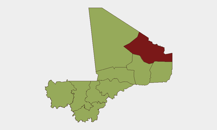
Situation Summary
Mali is experiencing a sustained wave of coordinated militant attacks across multiple regions, with insurgent and armed-group operations targeting military positions, detention facilities, and urban centers on 4–5 July 2026. The composite threat score of 77 and 27 tracked events reflect an active insurgency environment dominated by al-Qaeda-linked JNIM and Tuareg separatist groups. While Malian authorities claim operational control, the geographic spread and coordination of attacks signal sustained militant capability and intent to challenge state security forces nationwide.
Key Developments
- Anefis, Kidal Region (4 July) – Insurgents, including fighters from the Azawad Liberation Front (FLA), attacked Malian army positions; the assault marked one of several coordinated strikes across northeastern Mali.
- Gao, Northern Mali (4 July) – Armed groups conducted rocket and small-arms attacks on a military camp from dawn; at least six insurgents and one pro-government fighter were reported killed, with four additional government forces wounded.
- Sevare, Mopti Region (4 July) – Early-morning gunfire followed by four large explosions struck the western part of the city around 08:00 local time; the Malian military reported neutralizing approximately 20 "terrorists" and claimed situation control by midday.
- Aguelhoc, Northern Mali (4 July) – Armed groups attacked army positions in this northern town as part of the multi-location offensive.
- Kenioroba, South of Bamako (4 July) – Insurgents assaulted security forces at a major prison facility holding political opposition detainees; Malian security forces repelled the attack, though the incident underscores vulnerability of critical infrastructure near the capital.
- Nationwide Coordination (4–5 July) – Multiple sources confirm coordinated assaults by JNIM and separatist forces across at least five to seven locations spanning northern and central Mali, suggesting operational planning and sustained militant logistics.
- U.S. Travel Advisory Status (current) – The U.S. Department of State maintains a "Do Not Travel" designation for Mali, citing kidnapping, armed robbery, IED risks on roads, and restricted movement for diplomatic personnel outside Bamako.
Highest-Risk Areas
Kidal Region (83.6) significantly exceeds all other sub-national areas and remains the primary driver of national threat rankings, reflecting ongoing Tuareg separatist activity and insurgent presence in Mali's remote northeast. Bamako (55.8), despite a lower ranking, carries disproportionate risk due to its status as the national capital and presence of critical infrastructure, diplomatic missions, and high-value civilian targets; the 4 July prison assault demonstrates militant intent to strike near the capital. The remaining eight regions cluster at 53.6, indicating a broad secondary tier of risk: Ménaka, Kayes, Taoudénit, Gao, Koulikoro, Ségou, Sikasso, Timbuktu, and Mopti are all assessed at equivalent risk levels, with Mopti's recent violence (Sevare) and northern zones (Gao, Timbuktu, Taoudénit) presenting the most acute near-term exposure.
How GeoBit Would Assist
Security and risk teams should deploy AOI Monitoring & Early Warning on Kidal, Gao, Mopti, and approaches to Bamako to track militant movement and attack patterns in real time. Conflict & Military analysis (force-structure and weapons-capability tracking) and Network & Actor Analysis would support identification of JNIM and FLA operational cells and coordination nodes. Routing & Network Analysis capabilities enable identification of secure transit corridors and risk mitigation for personnel and supply movement within Mali.
7-Day Outlook
Militant groups will likely maintain elevated operational tempo over the next 7 days, with secondary attacks on military and government targets probable as insurgents test response capacity. Risk of further prison or detention-facility assaults remains elevated. Expect continued restrictions on civilian and diplomatic movement outside Bamako and intensified checkpoints on major routes.
Highest-Risk Areas — Ranked
| # | State / Region | Risk |
|---|---|---|
| 1 | Kidal | 83.6 |
| 2 | Bamako | 55.8 |
| 3 | Ménaka | 53.6 |
| 4 | Kayes | 53.6 |
| 5 | Taoudénit Region | 53.6 |
| 6 | Gao | 53.6 |
| 7 | Koulikoro | 53.6 |
| 8 | Ségou Region | 53.6 |
| 9 | Sikasso Region | 53.6 |
| 10 | Timbuktu | 53.6 |
| 11 | Mopti | 53.6 |
Sources
Previous Daily Briefs
A new Mali brief is written every day — each with its own risk map and downloadable CSV. Here's the last week; use the calendar to go further back.
📅 Browse every day by calendar →
Highlighted days have a brief. Tap a day for that day's map & analysis, or “csv” for that day's dataset ($5).
Atlas — our AI intelligence desk — emails them this snapshot personally. Nothing else, no list.