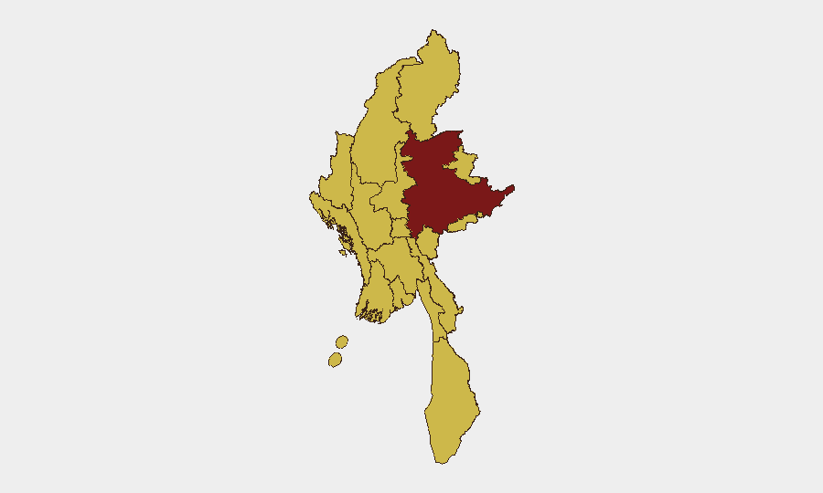
Situation Summary
Myanmar remains fractured by active civil conflict, with armed opposition groups controlling territory across the north and east while state security forces conduct ongoing operations. Curfews and communications blackouts persist in major urban centres (Yangon, Mandalay, Naypyitaw) as of end-June 2026. Open-source reporting for 4–6 July is sparse; no independently corroborated, location-specific security incidents have emerged in the last 48 hours, though baseline threat conditions—armed clashes, displacement, and flooding—remain active across high-risk regions.
Key Developments
- Yangon, Mandalay, Naypyitaw (as of 30 June) — Curfews and communications blackouts remain in effect in all three major cities, limiting civilian movement and access to services.
- Shan, Kachin, Sagaing, Chin regions (as of 30 June) — Armed opposition groups continue to hold territory; localized clashes and state security operations are expected to persist.
- Multiple regions (as of 30 June) — Active flooding compounds humanitarian strain and complicates overland travel and supply-chain access.
- Near Kanbe, eastern Myanmar (recent, magnitude 3.5) — A minor seismic event was recorded; no damage or casualty reports available.
- Countrywide (4–6 July) — No verified major conflict or security incidents reported in the last 24–48 hours; operational tempo remains below acute-incident threshold in open-source channels.
Highest-Risk Areas
Shan State (risk score 100) drives the composite threat picture and warrants primary focus; it is the epicentre of armed-group territorial control and clashes. A secondary tier—Tanintharyi, Chin, Sagaing, Kachin, and Wa regions (all risk 70)—forms a contiguous arc of active opposition presence and state counter-operations. Even major cities (Yangon, Mandalay, Naypyitaw) carry the same risk score as these conflict zones, reflecting the pervasiveness of curfews, comms blackouts, and governance instability. Regional flooding adds logistical friction across most provinces.
How GeoBit Would Assist
Security teams with personnel or assets in Myanmar should deploy AOI Monitoring & Early Warning on Shan State and secondary conflict zones to catch emerging clashes or displacement events before they escalate. Intel Sweep and multi-language OSINT (X, Telegram, local news) will surface real-time incident reporting and curfew changes faster than international media. Routing & Network Analysis can identify alternative supply routes and safe passage corridors around active conflict areas and flooded zones. Satellite & Imagery analysis provides ground truth on armed-group positions and infrastructure damage when open-source incident reporting is sparse.
7-Day Outlook
No sharp escalation is signalled by current open-source data; however, the persistence of curfews and the territorial stalemate across the north and east suggest sustained, low-to-moderate intensity clashes are likely to continue. Flooding and logistics disruptions will remain a secondary constraint on corporate operations and duty-of-care response. Communications blackouts may intermittently obscure emerging incidents, so reliance on OSINT fusion and imagery monitoring is advisable.
Highest-Risk Areas — Ranked
| # | State / Region | Risk |
|---|---|---|
| 1 | Shan State | 100 |
| 2 | Tanintharyi Region | 70 |
| 3 | Chin | 70 |
| 4 | Sagaing Region | 70 |
| 5 | Kachin State | 70 |
| 6 | Wa State (Northern Region) | 70 |
| 7 | Magway | 70 |
| 8 | Mandalay | 70 |
| 9 | Rakhine | 70 |
| 10 | Ayeyarwady | 70 |
| 11 | Yangon | 70 |
| 12 | Naypyitaw Union Territory | 70 |
Sources
Previous Daily Briefs
A new Myanmar brief is written every day — each with its own risk map and downloadable CSV. Here's the last week; use the calendar to go further back.
📅 Browse every day by calendar →
Highlighted days have a brief. Tap a day for that day's map & analysis, or “csv” for that day's dataset ($5).
Atlas — our AI intelligence desk — emails them this snapshot personally. Nothing else, no list.