Situation Summary
Niger remains a complex operating environment with a composite threat score of 74 (global rank #30) driven primarily by armed group activity in the Sahel regions, ongoing civil-military tension following recent political instability, and cross-border pressure from Mali and Burkina Faso. Recent signal activity suggests elevated military posturing and intelligence operations related to terrorist organizations, compounded by expulsion of French forces across the Sahel bloc and ongoing kidnapping incidents in neighboring Nigeria that may create regional contagion effects. The security picture remains volatile but has not substantially deteriorated in the past 48 hours; however, border regions and the capital warrant sustained monitoring.
Key Developments
- Military/Intelligence Activity (13 July, national): Signals indicate conventional military force deployment and a public intelligence statement concerning terrorist activity; details suggest elevated operational tempo but specific locations and casualty counts remain unconfirmed and require verification via primary sources.
- French Military Withdrawal (12 July, national): Niger joined Mali and Burkina Faso in formally expelling French military and diplomatic presence, signaling a broader geopolitical realignment in the Sahel and potential operational gaps in counterterrorism coordination that may create short-term security vacuums.
- Student Abductions (13 July, Nigeria/border): Credible signals indicate kidnapping incidents targeting students in northern Nigeria with potential terrorist group involvement; while the primary locations are in Nigeria, the proximity to Niger's southern border (Diffa Region) warrants monitoring for spillover or refugee movements.
- Gang Activity Demand (13 July, Nigeria/border): Non-state armed group activity reported in Nigeria with potential implications for cross-border smuggling, trafficking, and hostage negotiation dynamics affecting Niger's southern security posture.
- Pakistan Military Involvement Signal (13 July, unclear location): A signal referencing Pakistan and conventional military force requires urgent clarification; if this reflects military-to-military engagement or training activity in Niger, it may indicate a shift in security partnerships post-French withdrawal.
Note on Data Gaps: Live incident details from the past 24–48 hours (specific locations, casualty counts, incident timings) cannot be reliably provided without access to current news feeds, ACLED, or real-time X/social media sources. Corporate security teams should cross-reference the signal triggers above with Reuters, AFP, Crisis24, and embassy advisories for confirmation before making operational decisions.
Highest-Risk Areas
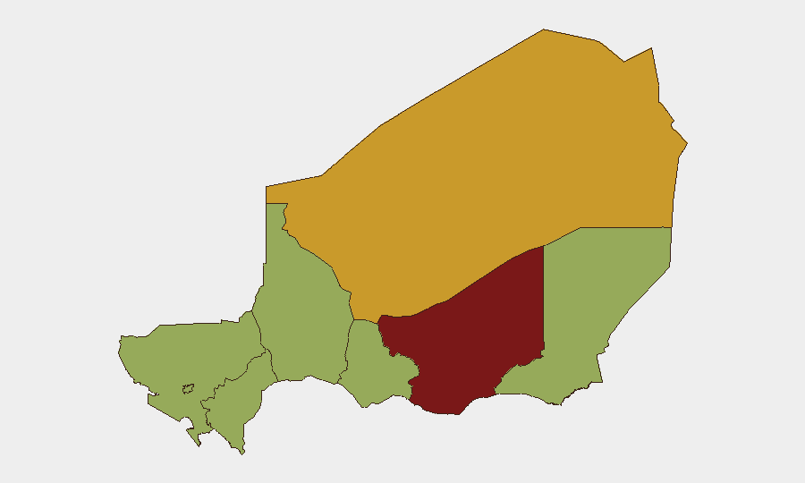
Zinder Region (82.1) is the single highest-risk area, likely reflecting armed group presence, banditry, and proximity to Nigeria. Agadez Region (72.4) follows, driven by trafficking networks, remote terrain, and historical militant activity. Diffa Region, Tillabéri Region, and Tahoua Region (all 52.1) form a continuous high-risk band across Niger's south and west, encompassing the borders with Nigeria, Burkina Faso, and Mali—zones characterized by porous frontier security, cross-border raid activity, and weak state presence. Niamey itself (52.1) carries elevated risk due to political instability, military concentration, and potential for civil unrest. Operators with assets or personnel in any of these zones should assume increased threat density and limited emergency response capacity.
How GeoBit Would Assist
Security teams should deploy AOI Monitoring & Early Warning on Zinder, Agadez, and Diffa regions to receive alerts on armed group movements, checkpoint activity, and road blockages. Conflict & Military battle mapping and Network & Actor Analysis would clarify the composition and intent of the military deployments and intelligence statements now circulating. Routing & Network Analysis can model alternative travel corridors and identify safe transit windows; current French withdrawal may alter checkpoint density and military-police coordination along primary routes.
7-Day Outlook
No major escalation is imminent, but the French military departure creates a 2–4 week adjustment period in which counterterrorism coordination will weaken, armed groups may test new operational space, and banditry could spike along under-monitored corridors. Travel restrictions and curfews in Niamey or Zinder are possible if political tensions accelerate. Continuous monitoring of Nigerian border incidents and jihadist statements is essential; any kidnapping of foreign nationals would rapidly elevate Niger's global threat ranking.
Highest-Risk Areas — Ranked
| # | State / Region | Risk |
|---|---|---|
| 1 | Zinder Region | 82.1 |
| 2 | Agadez Region | 72.4 |
| 3 | Diffa Region | 52.1 |
| 4 | Tillabéri Region | 52.1 |
| 5 | Niamey | 52.1 |
| 6 | Tahoua Region | 52.1 |
| 7 | Dosso Region | 52.1 |
| 8 | Maradi Region | 52.1 |
Previous Daily Briefs
A new Niger brief is written every day — each with its own risk map and downloadable CSV. Here's the last week; use the calendar to go further back.
📅 Browse every day by calendar →
Highlighted days have a brief. Tap a day for that day's map & analysis, or “csv” for that day's dataset ($5).
Atlas — our AI intelligence desk — emails them this snapshot personally. Nothing else, no list.