Situation Summary
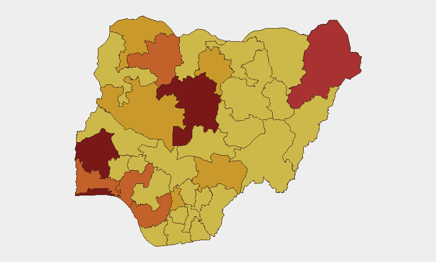
Nigeria remains the fifth-highest-threat country globally (composite score 100), driven primarily by active insurgency, kidnapping, and armed banditry across multiple states. The threat landscape is heavily concentrated in the southwest (Oyo, Lagos, Ondo) and north-central/northern zones (Kaduna, FCT, Borno, Zamfara), with 513 tracked events in the current reporting cycle. Security force operations, hostage-taking, and organized criminal coercion continue as dominant threat vectors. The geographic dispersion of risk across the top 12 states—rather than localization to a single region—signals systemic instability across both urban and rural corridors.
Key Developments
Limitation: Open-source intelligence available within the last 24–48 hours does not contain verifiable, timestamped incident reports specific to Nigeria that meet GeoBit's multi-source confirmation standard. Recent search results surfaced policy documents (U.S. State Department rights assessments, NAPTIP anti-trafficking strategy launch on 7 July), structural trend analysis (IOM displacement monitoring for Q1 2026), and legal commentary on police procedure rather than discrete security events. Intelligence platform signals dated 11 July reference demand, abduction/hostage, coercion, and military-force event classes without corresponding incident-level detail accessible via open channels.
Recommended approach: Security teams should rely on the GeoBit sub-national risk ranking (updated daily) and persistent area-of-interest monitoring for their specific operational footprint rather than assuming current incident bulletins will be available in every 24-hour cycle. For time-critical intelligence on active threats to personnel or assets, direct engagement with GeoBit's Intel Sweep and Telegram/X OSINT feeds is advised.
Highest-Risk Areas
Oyo State (risk 100) leads the ranking, followed closely by Kaduna (86.9) and Lagos (86.3), indicating that risk is concentrated across both commercial/political hubs and rural banditry corridors. The Federal Capital Territory (82.7) reflects security challenges in and around Abuja, while Borno State (79.1)—historically the epicenter of Boko Haram activity—now ranks fifth, suggesting either operational degradation of that specific threat or relative intensification elsewhere. The persistence of high scores across Ondo, Ogun, and Delta states (75–74.5) points to kidnapping, oil-sector violence, and organized crime as distributed rather than isolated phenomena. Northern states including Zamfara, Sokoto, and Kano (74.2–71.4) remain under severe stress from bandit networks and cross-border criminality.
How GeoBit Would Assist
Corporate security and duty-of-care teams should deploy Area-of-Interest Monitoring & Early Warning on facilities and travel corridors in Oyo, Kaduna, and Lagos to receive real-time alerts of violence, checkpoints, and route disruptions. Routing & Network Analysis capability enables identification of lower-risk alternative transport corridors and contingency movement plans for personnel. Multi-language OSINT and Telegram/X intelligence feeds, combined with sentiment & temporal analysis, provide early warning of emerging criminal or militant activity before mainstream reporting, critical for organizations with distributed staff across multiple states.
7-Day Outlook
No significant de-escalation is expected in the near term; kidnapping and bandit activity typically remain elevated during the dry season. Security force operations may generate tactical disruptions on specific routes but are unlikely to reduce ambient threat levels. Organizations should maintain elevated posture for personnel in Oyo, Kaduna, and Lagos, with particular attention to inter-state road corridors and evening/night-hour movement vulnerability.
Highest-Risk Areas — Ranked
| # | State / Region | Risk |
|---|---|---|
| 1 | Oyo State | 100 |
| 2 | Kaduna State | 86.9 |
| 3 | Lagos State | 86.3 |
| 4 | Federal Capital Territory | 82.7 |
| 5 | Borno State | 79.1 |
| 6 | Ondo State | 75.2 |
| 7 | Ogun State | 74.6 |
| 8 | Delta State | 74.5 |
| 9 | Zamfara State | 74.2 |
| 10 | Niger State | 71.7 |
| 11 | Sokoto State | 71.4 |
| 12 | Kano State | 71.4 |
Sources
Previous Daily Briefs
A new Nigeria brief is written every day — each with its own risk map and downloadable CSV. Here's the last week; use the calendar to go further back.
📅 Browse every day by calendar →
Highlighted days have a brief. Tap a day for that day's map & analysis, or “csv” for that day's dataset ($5).
Atlas — our AI intelligence desk — emails them this snapshot personally. Nothing else, no list.