Situation Summary
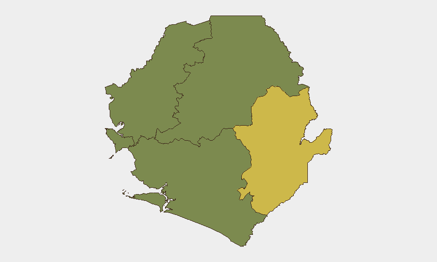
Sierra Leone remains at a low composite threat level (score 9) with no discrete security incidents confirmed in the last 24–48 hours. The security environment is regionally uneven, with the Eastern Province carrying significantly elevated risk (68) compared to the Western Area (35) and the three northern/southern provinces (all 0). The absence of recent reported events does not indicate structural stability; underlying drivers of localized conflict, crime, and inter-community tensions persist, particularly in diamond-mining regions and chiefdom-boundary areas in the east.
Key Developments
No verified security incidents, civil unrest, crime events, or infrastructure failures have been identified in Sierra Leone during the 24–48 hour window of 2–4 August 2026 from independent web and social sources accessible to GeoBit at briefing time.
Note on recent context (late July, outside 48h window):
For situational awareness, regional CID operations in Bo District (July 28) resulted in four arrests related to a stabbing death; a new police post was authorized in Sundehun community (July 26) following community-police security meetings; and the Kailahun Police Barracks fire (August 1) prompted a visit and reassurance call by the Inspector General. These developments underscore latent tensions in chiefdoms and sporadic crime in provincial towns, but none constitute active crises at briefing time.
Highest-Risk Areas
The Eastern Province (risk 68) dominates the sub-national threat profile and warrants primary monitoring. This region encompasses Kailahun and Kenema districts—historically volatile zones with mineral-extraction pressures, inter-chiefdom land disputes, and cross-border dynamics with Guinea and Liberia. The Western Area (risk 35), centered on Freetown, carries secondary risk driven by urban crime, informal settlement tensions, and transient security events that occasionally spike during political or economic friction.
The Northern Province, North West Province, and Southern Province all register zero tracked events and low composite scores, reflecting either lower underlying risk or reduced reporting/monitoring visibility. Corporate security teams with operations in the north and south can reasonably expect a lower incident frequency, though blanks on the risk map should not be mistaken for structural immunity.
How GeoBit Would Assist
Intel Sweep & OSINT Fusion would capture fragmented social media, radio SIGINT, and local news signals to detect crime clusters, protest activity, or police operations in real-time before they escalate. AOI Monitoring & Early Warning would establish persistent watch on Kailahun, Kenema, Bo, and Freetown with automated alerting for violence, fire/infrastructure damage, or political gatherings. GIS & Spatial Analysis combined with Routing & Network Analysis would enable security teams to map safe corridors for staff movement, identify no-go zones post-incident, and plan alternate logistics routes around Eastern Province hotspots.
7-Day Outlook
No acute security trigger is evident for the immediate week ahead. However, residual tensions in chiefdom land-access disputes and sporadic urban crime in Freetown warrant sustained low-level monitoring. Contingency planning should assume that a localized incident (e.g., mining-zone violence, police operation, or inter-community clash) in the Eastern Province could briefly disrupt regional travel or business continuity; early warning systems should be active to give duty-of-care teams 6–12 hours lead time for staff advisories.
Highest-Risk Areas — Ranked
| # | State / Region | Risk |
|---|---|---|
| 1 | Eastern Province | 68 |
| 2 | Western Area | 35 |
| 3 | North West Province, Sierra Leone | 0 |
| 4 | Northern Province, Sierra Leone | 0 |
| 5 | Southern Province, Sierra Leone | 0 |
Sources
- sierraleonemonitor.com
- facebook.com
- sierraleonemonitor.com
- sierraloaded.sl
- sierraloaded.sl
- thesierraleonetelegraph.com
- press.un.org
- sierraleonemonitor.com
- thesierraleonetelegraph.com
- npha.gov.sl
- thesierraleonetelegraph.com
- sierraloaded.sl
- sierraloaded.sl
- truthmedia.sl
- mail.ceoafrica.com
- travel.gc.ca
- sierraleoneconcordtimes.com
- premiermedia-sl.com
Previous Daily Briefs
A new Sierra Leone brief is written every day — each with its own risk map and downloadable CSV. Here's the last week; use the calendar to go further back.
📅 Browse every day by calendar →
Highlighted days have a brief. Tap a day for that day's map & analysis, or “csv” for that day's dataset ($5).
Atlas — our AI intelligence desk — emails them this snapshot personally. Nothing else, no list.