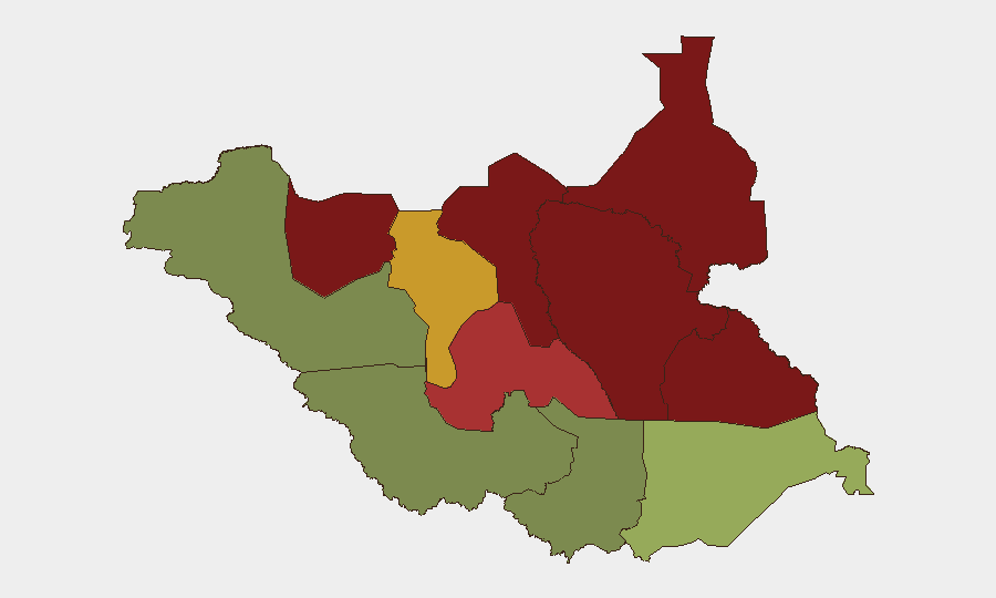
Situation Summary
South Sudan remains under sustained conflict pressure, with composite threat ranking at #28 globally (score 65). No discrete security incidents have been verified in the last 24–48 hours; however, the country continues to experience endemic armed-group activity, communal violence, and humanitarian pressure across multiple northern and central states. The security environment remains volatile and fragmented by geography, with significant risk concentration in the oil-producing Unity and Jonglei states.
Key Developments
Assessment: GeoBit's live web research (last 24 hours) has not identified verified discrete incidents meeting the 24–48-hour window. Open-source reporting for South Sudan in this period remains sparse or non-specific. Ongoing context includes:
- Northern conflict zones (Jonglei, Unity, Upper Nile) remain under persistent armed-group presence and inter-communal tension; no new incidents confirmed in current window.
- Humanitarian access constraints reported in conflict-affected areas, particularly Upper Nile and Greater Pibor Administrative Area, continue to limit NGO and UN operations—a standing condition rather than a new event.
- Oil production and supply-chain operations in Unity and Ruweng states operate under elevated security protocols; no new disruptions confirmed in last 24–48 hours.
*Note:* The absence of verified incident reports in the last 24–48 hours does not indicate a reduction in threat. South Sudan's conflict is characterized by distributed, ongoing violence with variable coverage in open-source reporting. Corporate security teams should not interpret silence as safety.
Highest-Risk Areas
Unity (95) and Jonglei (93) dominate the risk landscape, driven by active armed-group presence, inter-communal conflict over cattle and territory, and limited state authority. Upper Nile (88) and Greater Pibor Administrative Area (87) present similar threat profiles, with communal violence and armed-group activity hampering humanitarian and commercial operations. Northern Bahr el Ghazal (82) and Lakes (78) follow, reflecting secondary conflict nodes. Central Equatoria (35), Western Equatoria (38), and Western Bahr el Ghazal (28)—the southern and southwestern states—are substantially lower-risk and include Juba, the capital, where corporate and diplomatic infrastructure is concentrated. Risk in the north is driven by competition for pastoralist resources, weak state capacity, and armed-group recruitment; southern risk is primarily urban crime and political volatility.
How GeoBit Would Assist
Security teams should employ Intel Sweep and multi-language OSINT (X/Twitter, Telegram, radio SIGINT) to monitor armed-group communications and early signs of coordinated activity in Unity and Jonglei. AOI Monitoring & Early Warning on high-risk state capitals and supply-chain nodes (oil fields, airstrips, logistics hubs) provides persistent detection of unusual movement or incident precursors. Conflict & Military mapping and entity network analysis enable tracking of armed-group force disposition and alliance shifts. Satellite & Imagery analysis and alternative route/journey planning support operational security for mobile teams and convoy routing away from flashpoints.
7-Day Outlook
No significant escalation is indicated in current signals, but the baseline threat remains high. Seasonal pastoral migration pressures (August–September) typically correlate with increased inter-communal livestock raids in Jonglei and Unity. Corporate and NGO operations should maintain heightened operational security posture and ensure contingency planning is current.
Highest-Risk Areas — Ranked
| # | State / Region | Risk |
|---|---|---|
| 1 | Unity | 95 |
| 2 | Jonglei | 93 |
| 3 | Upper Nile | 88 |
| 4 | Greater Pibor Administrative Area | 87 |
| 5 | Northern Bahr el Ghazal | 82 |
| 6 | Lakes | 78 |
| 7 | Warrap | 72 |
| 8 | Ruweng Administrative Area | 68 |
| 9 | Eastern Equatoria | 52 |
| 10 | Western Equatoria | 38 |
| 11 | Central Equatoria | 35 |
| 12 | Western Bahr el Ghazal State | 28 |
Sources
Previous Daily Briefs
A new South Sudan brief is written every day — each with its own risk map and downloadable CSV. Here's the last week; use the calendar to go further back.
📅 Browse every day by calendar →
Highlighted days have a brief. Tap a day for that day's map & analysis, or “csv” for that day's dataset ($5).
Atlas — our AI intelligence desk — emails them this snapshot personally. Nothing else, no list.