Situation Summary
Sudan remains in active civil war between the Sudanese Armed Forces (SAF) and the Rapid Support Forces (RSF), with North Kordofan State experiencing the most acute military pressure and civilian harm. Drone strikes, conventional artillery, and ground combat continue to degrade civilian infrastructure—hospitals, schools, fuel stations—and restrict humanitarian access across multiple states. Escalating displacement, food insecurity affecting 5 million people, and the recent in-absentia conviction of RSF leadership underscore a conflict trajectory toward prolonged attrition and deepening humanitarian collapse. The security environment for international and local staff, supply lines, and critical facilities remains severely constrained.
Key Developments
- El-Obeid, North Kordofan (13–14 Jul): RSF drone strikes and artillery fire continued against civilian targets including hospitals and schools; SAF reported shooting down a fourth Chinese-made FH-95 drone over the city. Civilian casualties and critical-infrastructure damage ongoing.
- Port Sudan, Red Sea State (13–14 Jul): The Anti-Terrorism and Crimes Against the State Court sentenced RSF commander Mohamed Hamdan Dagalo (Hemedti), his deputy Abdel Rahim Dagalo, and 14–15 other RSF leaders to death in absentia for war crimes, crimes against humanity, and genocide in West Darfur.
- Rural North Kordofan near Bara and Om-Rowaba (13–14 Jul): Escalated fighting and drone attacks are forcing further displacement; unexploded ordnance poses acute threat to returning populations.
- Northern Kordofan and Omdurman corridors (13–14 Jul): Intensified RSF drone strikes on civilian vehicles and infrastructure further restricting humanitarian access and public movement along key relief routes.
- Nationwide humanitarian situation (14 Jul): World Food Programme warned Sudan is sliding toward deeper hunger crisis; approximately 5 million people now at emergency or catastrophic hunger levels due to conflict-related access constraints and elevated agricultural costs.
- Child protection indicators nationwide (13–14 Jul): Rights monitors report worsening situation for millions of children, with ongoing violence, disrupted essential services (health, education, water), and escalating protection risks across conflict-affected states.
Highest-Risk Areas
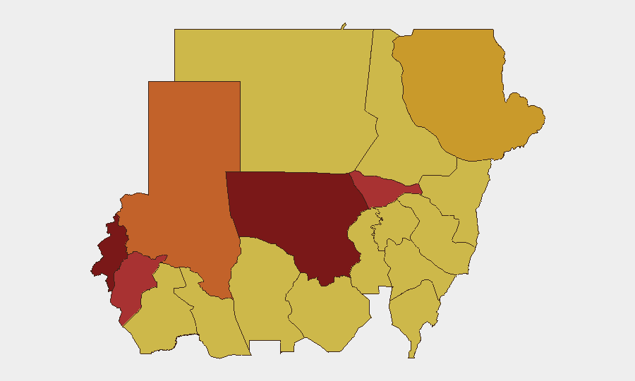
North Kordofan State (risk 100) and West Darfur (83.3) are driving the overall threat level, followed by Al Khartum (79.1) and Central Darfur (76.1). North Kordofan's ranking reflects sustained SAF–RSF conventional combat, dense drone bombardment of civilian areas, and severe displacement; West Darfur remains a focal point for documented war crimes and RSF operations. Al Khartum's elevated risk reflects its role as the capital and seat of SAF command, where detention operations, political instability, and spillover combat remain acute. Red Sea State (72.3), despite being lower-ranked, carries elevated risk for international staff due to port congestion, maritime security concerns, and SAF security-force activity.
How GeoBit Would Assist
Security and duty-of-care teams should deploy AOI (Area-of-Interest) Monitoring & Early Warning on North Kordofan, West Darfur, and Al Khartum to detect combat escalation, drone activity, and displacement patterns in near-real time. Battle mapping, force-structure tracking, and satellite/imagery analysis provide granular visibility of SAF and RSF positions, supply lines, and infrastructure damage to inform movement decisions and facility hardening. Routing & Network Analysis can model alternative supply and evacuation corridors around active conflict zones and identify safe passage windows based on current drone and artillery patterns.
7-Day Outlook
Conventional military operations and drone strikes are expected to persist across North Kordofan and Darfur states without significant territorial shift. Humanitarian access will remain severely constrained, likely forcing further agency downsizing and increased reliance on local staff. Detention operations and security-force activity in Al Khartum may intensify following the in-absentia war-crimes convictions, creating additional risk for international personnel.
Highest-Risk Areas — Ranked
| # | State / Region | Risk |
|---|---|---|
| 1 | North Kordofan State | 100 |
| 2 | West Darfur | 83.3 |
| 3 | Al Khartum | 79.1 |
| 4 | Central Darfur State | 76.1 |
| 5 | North Darfur State | 73.4 |
| 6 | Red Sea State | 72.3 |
| 7 | Kassala State | 70.8 |
| 8 | Blue Nile | 70 |
| 9 | River Nile State | 70 |
| 10 | Aj Jazira | 70 |
| 11 | Al Qadarif State | 70 |
| 12 | Sennar State | 70 |
Sources
Previous Daily Briefs
A new Sudan brief is written every day — each with its own risk map and downloadable CSV. Here's the last week; use the calendar to go further back.
📅 Browse every day by calendar →
Highlighted days have a brief. Tap a day for that day's map & analysis, or “csv” for that day's dataset ($5).
Atlas — our AI intelligence desk — emails them this snapshot personally. Nothing else, no list.