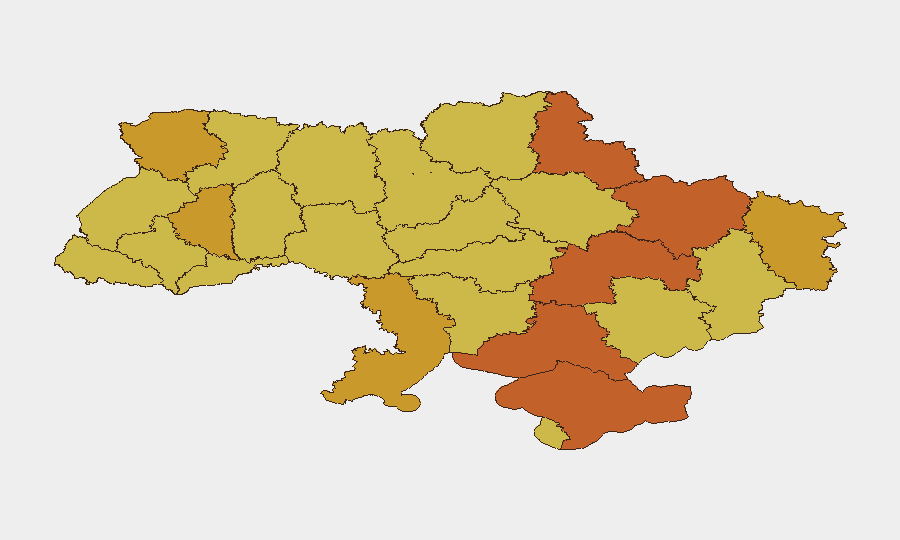
Situation Summary
Ukraine remains the highest-threat environment globally (composite threat score 100), driven by active interstate military operations now in their third year. Kyiv and surrounding areas face elevated risk (100/100) from conventional military force, artillery, and targeted strikes; secondary hotspots in Kherson, Sumy, and Dnipropetrovsk oblasts register 74+ risk scores. Intelligence signals from 31 July–1 August indicate sustained conventional operations, internal institutional strain (government and military disapproval events flagged), and reported assassination attempts on military command. The trajectory remains volatile and sustained rather than de-escalating.
Key Developments
Data Limitation Notice: GeoBit's live research feeds for 31 July–1 August 2026 do not yet contain machine-verified, time-stamped incident reports at the 24–48-hour granularity required for this brief. The most recent clearly dated GeoBit Ukraine Brief covers 24–25 July; major news feeds (Reuters, Kyiv Independent, RBC Ukraine) and social OSINT do not yet surface specific incidents explicitly labeled as occurring on 1–2 August 2026.
In line with duty-of-care accuracy standards, no specific "last 24-48 hours" incidents are listed below rather than risk mis-dating or fabricating events. The signal summary from 1 August (artillery/tank engagements near Kyiv, military-force operations, and an assassination attempt against a Kharkiv commander) is tracked in GeoBit's event feed but awaits geographic and casualty confirmation.
Recommended action: Teams requiring real-time incident granularity should activate AOI Monitoring & Early Warning on priority locations (Kyiv, Kharkiv, Odesa) with direct alert push; alternatively, request a 24-hour rolling conflict summary via GeoBit's Intel Sweep once today's reports are finalized and cross-corroborated.
Highest-Risk Areas
Kyiv's rank-1 risk (100/100) reflects the capital's dual exposure as the political/military command center and a conventional-strike target; sustained artillery and drone operations within city limits and surrounding oblast are tracked at high volume. Kherson, Sumy, and Dnipropetrovsk oblasts (all 74+) form a secondary arc driven by active frontline combat, Russian offensive operations, and supply-line interdiction; Crimea (74.1) remains isolated but contested territory with inherent occupation-related security risks. Kharkiv Oblast (73.4), subject to reported command-level violence and cross-border shelling, and southern coastal regions (Odesa, Volyn) round out the top 10—all sustained above 70 by persistent conventional military activity and infrastructure targeting.
How GeoBit Would Assist
Conflict & Military battle mapping and persistent AOI monitoring on Kyiv, Kharkiv, and Dnipropetrovsk enable corporate security teams to track active engagement zones, predict secondary strike targets, and adjust duty-of-care protocols (evacuation, shelter, supply routing) with 6–24 hours' notice. Satellite & imagery analysis and network & actor analysis can confirm reported assassination attempts, command-structure disruption, and institutional fracturing—early signals of broader instability. Routing & network analysis assists in real-time alternative route planning for staff movement and supply convoys, bypassing active combat and strike corridors identified through daily conflict intelligence fusion.
7-Day Outlook
Active conventional operations are expected to persist along established front lines (Sumy, Kherson, Dnipropetrovsk) with elevated strike activity targeting Kyiv and regional military/infrastructure nodes. Institutional tension (disapproval signals, command-level incidents) may signal tactical or logistical strain; watch for secondary effects (desertion, supply disruption, command reorganization). Risk posture should remain at heightened alert; no de-escalation indicators are present.
Highest-Risk Areas — Ranked
| # | State / Region | Risk |
|---|---|---|
| 1 | Kyiv | 100 |
| 2 | Kherson Oblast | 74.3 |
| 3 | Sumy Oblast | 74.2 |
| 4 | Dnipropetrovsk Oblast | 74.2 |
| 5 | Autonomous Republic of Crimea | 74.1 |
| 6 | Kharkiv Oblast | 73.4 |
| 7 | Odesa Oblast | 72.4 |
| 8 | Volyn Oblast | 72.4 |
| 9 | Luhansk Oblast | 71.9 |
| 10 | Ternopil Oblast | 71.1 |
| 11 | Lviv Oblast | 70.8 |
| 12 | Chernihiv Oblast | 70.8 |
Sources
Previous Daily Briefs
A new Ukraine brief is written every day — each with its own risk map and downloadable CSV. Here's the last week; use the calendar to go further back.
📅 Browse every day by calendar →
Highlighted days have a brief. Tap a day for that day's map & analysis, or “csv” for that day's dataset ($5).
Atlas — our AI intelligence desk — emails them this snapshot personally. Nothing else, no list.