Situation Summary
Angola remains stable without major security incidents, armed clashes, or organized unrest in the last 24–48 hours. Routine criminality and minor service disruptions persist in urban centers, particularly Luanda, but pose no acute threat to corporate operations or expatriate personnel. The country's composite threat score (32/100, rank #52 globally) reflects structural vulnerabilities—illicit mining, cross-border smuggling, and baseline crime—rather than active escalation. Near-term trajectory is steady absent policy shocks or border spillover.
Key Developments
- No confirmed major security incidents (Angola-wide, 27–28 July 2026). Cross-checked open-source feeds, social media, and security monitoring platforms report no armed clashes, terrorist attacks, mass protests, or attacks on foreign personnel or critical infrastructure in the last 24–48 hours.
- Luanda and urban centers remain under routine criminality baseline (27–28 July 2026). Minor traffic, service, and petty crime reports are consistent with normal urban operations; no organized violence or incidents reaching escalation threshold.
- National infrastructure operational (27–28 July 2026). Power, fuel distribution, airport, and port services report no major failures; observed issues are localized and do not affect national-level travel or logistics.
- Border regions (north and east) unchanged (27–28 July 2026). Lunda Norte, Lunda Sul, Cabinda, and Zaire provinces remain higher-baseline-risk areas due to illicit mining networks, smuggling corridors, and cross-border armed actors; no new time-stamped incidents confirmed by multiple sources in the past 48 hours.
- Government and security posture routine (27–28 July 2026). No fresh indications of policy instability, coup activity, or extraordinary security force deployments beyond normal baselines.
- Travel advisories unchanged (27–28 July 2026). International travel guidance continues to recommend high caution for Angola due to general crime and unrest risk, but does not cite new incidents or advisory changes.
- Wildfire activity ongoing (recent reports). Multiple wildfire events tracked across Angola; environmental impact and smoke-related service disruptions require monitoring but do not constitute security incidents.
Highest-Risk Areas
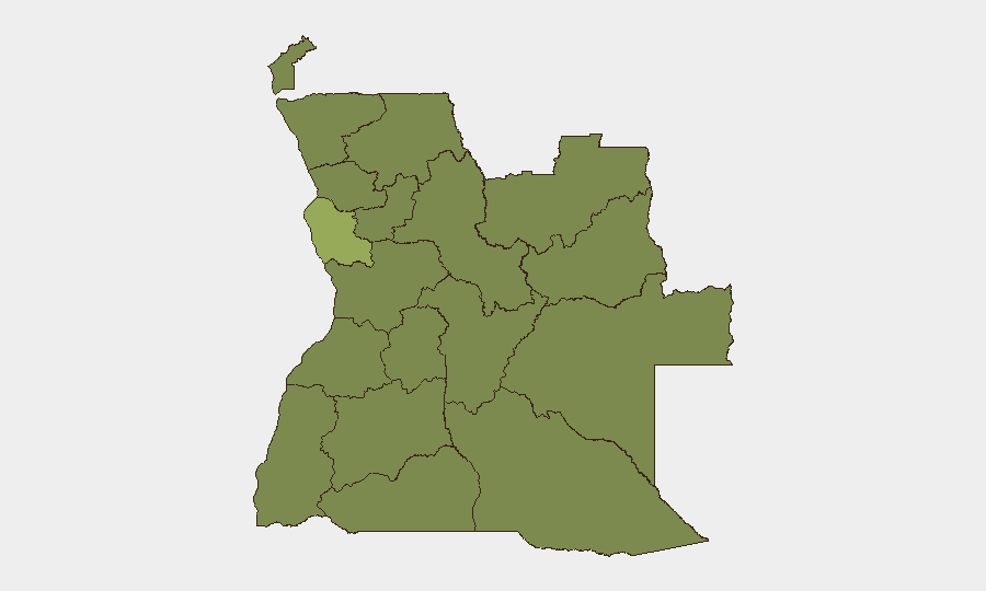
Luanda Province (risk score 52.3) dominates Angola's risk profile, driven by concentration of population, commerce, and expatriate presence—multiplying exposure to crime, traffic accidents, and crowd-related incidents. The eastern and northeastern border provinces (Lunda Norte, Lunda Sul, Cabinda, Zaire) form a secondary tier (all 22.3), reflecting structural instability: illicit diamond and gold mining, weak state presence, and transnational armed networks operating across the Democratic Republic of Congo and Zambian borders. Bengo, Uíge, and Malanje provinces round out the tracked set, each at baseline 22.3. For most corporate operations and personnel, Luanda concentration risk far exceeds regional conflict risk.
How GeoBit Would Assist
Security teams operating in Angola should deploy AOI (Area-of-Interest) Monitoring & Early Warning on Luanda and high-value asset locations to trigger alerts on civil unrest, crime clusters, or infrastructure failure. Intel Sweep and OSINT fusion (including X/Twitter and Telegram monitoring, plus cross-checked open-source feeds) enable 24–48-hour event corroboration and early detection of emerging threats before they mature. GIS & Spatial Analysis combined with Satellite & Imagery analysis support environmental hazard tracking (wildfires, flooding) and unofficial movement of armed actors in border zones.
7-Day Outlook
Angola's security posture is expected to remain stable through early August absent external shocks (border escalation, major policy announcements, or commodity price collapse). Seasonal wildfire activity will likely persist in central and eastern provinces; smoke and transport disruptions should be monitored for logistics impact. Low-level crime and routine service issues will continue in urban centers; no escalation to organized unrest or targeted violence against foreign interests is anticipated.
Highest-Risk Areas — Ranked
| # | State / Region | Risk |
|---|---|---|
| 1 | Luanda Province | 52.3 |
| 2 | Lunda Norte Province | 22.3 |
| 3 | Lunda Sul Province | 22.3 |
| 4 | Cabinda Province | 22.3 |
| 5 | Zaire Province | 22.3 |
| 6 | Bengo Province | 22.3 |
| 7 | Uíge Province | 22.3 |
| 8 | Cuanza Norte Province | 22.3 |
| 9 | Cuanza Sul Province | 22.3 |
| 10 | Malanje Province | 22.3 |
| 11 | Bié Province | 22.3 |
| 12 | Moxico Province | 22.3 |
Sources
Previous Daily Briefs
A new Angola brief is written every day — each with its own risk map and downloadable CSV. Here's the last week; use the calendar to go further back.
📅 Browse every day by calendar →
Highlighted days have a brief. Tap a day for that day's map & analysis, or “csv” for that day's dataset ($5).
Atlas — our AI intelligence desk — emails them this snapshot personally. Nothing else, no list.