Situation Summary
Benin remains a stable lower-risk jurisdiction globally (#46 composite threat score) with no confirmed security incidents in the last 24–48 hours. The country's primary security driver remains insurgency and terrorism risk concentrated in the northern border departments, where Al-Qaeda and Islamic State-affiliated groups operate across the Sahel region. Overall trajectory is stable, though northern departments face persistent and elevated threat from cross-border militant activity.
Key Developments
No discrete security, conflict, crime, or travel-risk incidents have been confirmed in Benin within the last 24–48 hours (17–18 August 2026). Recent historical incidents from early-to-mid August (outside the current 24–48h window) include:
- 12 August 2026 – Cotonou: Joint police raid in Missèkplé neighborhood (behind Sainte-Rita Catholic Church) netted 21 arrests and large seizures of Indian hemp and suspected counterfeit pharmaceuticals.
- 14 August 2026 – National: National Center for Digital Investigations (CNIN) arrested TikTok content creators and accomplices for live sexual exhibitionism and cybercrime offenses.
- 10 August 2026 – Togba: District police dismantled a burglary and drug-trafficking network, arresting four suspects linked to criminal conspiracy and trafficking of psychoactive substances.
- 16 August 2026 – Parakou: Opposition party Les Démocrates held a political "remobilisation" meeting in northern Borgou Department.
Until new incidents are confirmed within the current 24–48h window, these serve as context for Benin's ongoing crime and political environment but do not constitute current developments.
Highest-Risk Areas
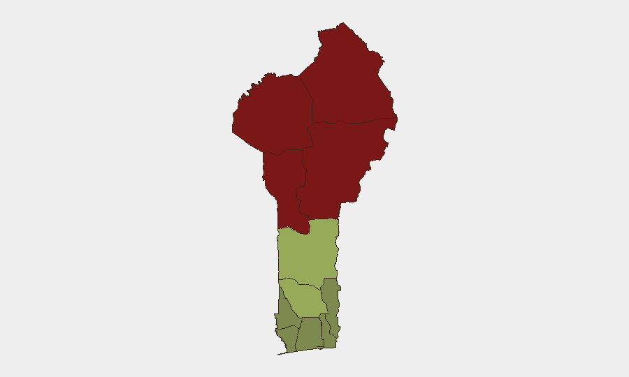
Northern departments drive Benin's threat profile. Alibori (#1, risk 92), Atakora (#2, risk 88), Donga (#3, risk 85), and Borgou (#4, risk 83) departments form a high-risk arc along the Niger and Burkina Faso borders, where ISIS and AQIM-aligned splinter groups conduct raids, kidnappings, and ambushes against military and civilian targets. These zones remain under active militant pressure and have experienced episodic displacement since 2015. Zou (risk 45) and Collines (risk 42) departments present moderate risk, while southern departments—Ouémé (risk 22), Littoral (risk 25), and Atlantique (risk 28)—remain significantly lower-risk, reflecting their distance from the Sahel conflict and concentration of commercial and administrative activity.
How GeoBit Would Assist
Security teams with personnel or assets in Benin would prioritize AOI Monitoring & Early Warning on the four northern departments to detect militant movement, displacement alerts, and attacks; OSINT Fusion (multi-language social media, radio SIGINT, and event feeds) to track cross-border group activity and threat communication; and Routing & Network Analysis to maintain dynamic alternative travel routes for staff in moderate-risk zones. Conflict & Military mapping and entity/actor analysis would support situational awareness of armed group presence and capability shifts across the Sahel theater.
7-Day Outlook
No imminent escalation is signaled for the next 7 days. Northern departments will remain under baseline persistent threat from cross-border insurgency, while southern urban centers continue routine crime and law-enforcement operations. Any material change in militant activity or mass-casualty incidents would likely first appear in radio or social-media signals monitored by OSINT feeds.
Highest-Risk Areas — Ranked
| # | State / Region | Risk |
|---|---|---|
| 1 | Alibori Department | 92 |
| 2 | Atakora Department | 88 |
| 3 | Donga Department | 85 |
| 4 | Borgou Department | 83 |
| 5 | Zou Department | 45 |
| 6 | Collines Department | 42 |
| 7 | Plateau Department | 38 |
| 8 | Kouffo Department | 35 |
| 9 | Mono Department | 32 |
| 10 | Atlantique Department | 28 |
| 11 | Littoral | 25 |
| 12 | Ouémé Department | 22 |
Sources
Previous Daily Briefs
A new Benin brief is written every day — each with its own risk map and downloadable CSV. Here's the last week; use the calendar to go further back.
- August 16, 2026
- August 14, 2026
- August 12, 2026
- August 11, 2026
- August 10, 2026
- August 9, 2026
- August 8, 2026
📅 Browse every day by calendar →
Highlighted days have a brief. Tap a day for that day's map & analysis, or “csv” for that day's dataset ($5).
Atlas — our AI intelligence desk — emails them this snapshot personally. Nothing else, no list.