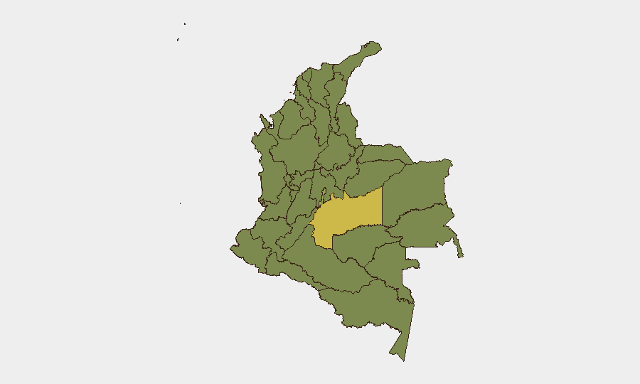
Situation Summary
Colombia remains the 31st highest-threat country globally (composite score 69) with 325 tracked events, reflecting persistent armed-group violence, criminal activity, and political instability concentrated in rural and border zones. Over July 14–17, the Defensoría del Pueblo documented at least six significant incidents—including bombings, armed clashes, and forced displacement—across Arauca, Norte de Santander, Vichada, Cauca, and Chocó departments. The threat trajectory remains elevated in remote and periphery regions, particularly where ELN and other illegal armed groups operate; capital and urban centers remain comparatively stable but subject to routine criminal and protest activity.
Key Developments
- Tame, Arauca (16 July): ELN-attributed explosive attack on Betoyes police substation killed two officers and one civilian, wounded nine officers. Part of escalating hostilities in this rural border zone.
- Tibú, Norte de Santander (17 July): Car-bomb attack near military installation, attributed to ELN, injured three with shrapnel and traumatized four others. Signals continuing violence in this Venezuela border corridor.
- Cumaribo, Vichada (14–17 July): Small-arms attack in Saracure Río Cada indigenous reserve killed three young indigenous people, wounded one 45-year-old woman. Reflects rising targeting of indigenous and isolated rural populations.
- Cauca Department (14–17 July): Armed clashes and explosive incidents by illegal groups caused civilian displacement and infrastructure damage across rural sectors; specific municipalities not named in alert.
- Chocó Department (14–17 July): Armed confrontations and threats from illegal armed groups drove forced displacement along river corridors and remote areas.
- Defensoría del Pueblo Alert (20 July): Colombia's human-rights ombudsman issued formal warning of armed-group violence, displacement, and inadequate state protection in conflict zones, signaling institutional concern over escalation and civilian safety.
Highest-Risk Areas
Meta Department (65.3) leads all sub-national zones by a significant margin, reflecting persistent armed-group presence and territorial disputes in rural Llanos and jungle-frontier areas. The Capital District (44.1) ranks second due to urban crime, protest activity, and occasional political violence, though absolute risk remains lower than Meta. The Caribbean coast (Atlántico, 39.1) and Pacific/Andean rural zones (Cauca, Nariño, Caquetá, 38.7–37.6) show elevated risk driven by illegal armed-group activity, drug trafficking, and indigenous/Afro-Colombian community vulnerability. North-border zones (Norte de Santander, Arauca, 37.6–37.6) remain high-risk due to Venezuelan cross-border activity, ELN presence, and trafficking routes.
How GeoBit Would Assist
Security teams operating in Colombia would leverage AOI Monitoring & Early Warning to track high-risk departments—particularly Meta, Arauca, and Norte de Santander—with persistent alerting on armed-group activity and displacement events. Conflict & Military mapping and Network & Actor Analysis enable real-time understanding of ELN and rival faction positions, capabilities, and recent tactical shifts. Routing & Network Analysis supports alternative journey planning around active conflict zones, while Intel Sweep and multi-language OSINT (including Defensoría alerts and regional media) provide 24–48-hour visibility into emerging threats before they affect staff or assets.
7-Day Outlook
Armed-group violence in rural and border departments is expected to remain elevated through late July, with ELN operations in Arauca and Norte de Santander likely to persist. Urban and capital-zone stability is not under immediate threat, but travel to or through peripheral departments warrants heightened vigilance and coordination with local security partners. Any escalation in Venezuela–Colombia cross-border activity or significant police/military offensive could rapidly shift displacement and tactical risk within 3–7 days.
Highest-Risk Areas — Ranked
| # | State / Region | Risk |
|---|---|---|
| 1 | Meta Department | 65.3 |
| 2 | Capital District | 44.1 |
| 3 | Atlántico Department | 39.1 |
| 4 | Cauca | 38.7 |
| 5 | Nariño | 38.5 |
| 6 | Caquetá Department | 37.6 |
| 7 | Norte de Santander Department | 37.6 |
| 8 | Amazonas | 37.2 |
| 9 | Antioquia Department | 36.5 |
| 10 | Valle del Cauca Department | 35.7 |
| 11 | Cesar Department | 35.7 |
| 12 | Tolima Department | 35.7 |
Sources
Previous Daily Briefs
A new Colombia brief is written every day — each with its own risk map and downloadable CSV. Here's the last week; use the calendar to go further back.
📅 Browse every day by calendar →
Highlighted days have a brief. Tap a day for that day's map & analysis, or “csv” for that day's dataset ($5).
Atlas — our AI intelligence desk — emails them this snapshot personally. Nothing else, no list.