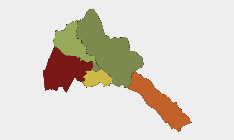
Situation Summary
Eritrea maintains a composite threat ranking of #73 globally with no tracked security events in the current 24–48-hour window. Open-source reporting shows no verified, location-specific incidents inside Eritrea dated 26–27 August 2026; the information environment remains constrained by limited international media coverage and government information controls. The security baseline remains stable at the national level, though sub-national risk concentrations—particularly in Gash-Barka and the Southern Red Sea Region—warrant sustained attention for organizations with personnel or assets in those areas.
Key Developments
No discrete, verified security or unrest incidents with specific location and date markers were identified in Eritrea during 26–27 August 2026 in available open-source channels.
*Note on information environment:* Eritrea's restrictive media landscape and limited international news infrastructure mean that absence of reported incidents does not guarantee absence of ground-level activity. Organizations reliant solely on open reporting face inherent data gaps. Classified, proprietary, or on-the-ground intelligence feeds (diplomatic cables, NGO security networks, mission reporting) remain essential for closing visibility gaps.
Highest-Risk Areas
Gash-Barka (risk score 92) and the Southern Red Sea Region (75) are the primary drivers of Eritrea's sub-national risk profile. Gash-Barka's elevated risk reflects historical patterns of cross-border tension, trafficking activity, and limited state presence; the Southern Red Sea Region is exposed to maritime security risks and regional spillover from the broader Horn of Africa operating environment. In contrast, Maekel Region (Asmara and immediate surroundings, risk 18) and the Northern Red Sea Region remain relatively lower-risk for corporate security purposes. Organizations operating outside the capital should prioritize location-specific threat assessment and liaison with ground contacts in higher-risk zones.
How GeoBit Would Assist
Intel Sweep and multi-language OSINT fusion capabilities enable continuous scanning of regional news, social media, and opposition narratives to detect early signals of instability or civil unrest not yet visible in mainstream reporting. AOI Monitoring & Early Warning with persistent area-of-interest watches on Gash-Barka and the Southern Red Sea Region would provide automated alerting of emerging incidents, travel disruptions, or security shifts, critical given the information constraints. Network & Actor Analysis and regime-stability assessment tools allow security teams to map government control patterns, identify flashpoint actors, and contextualize regional claims (such as recent opposition allegations of Eritrean involvement in neighboring conflicts) against verified ground conditions and historical precedent.
7-Day Outlook
No acute escalation signals are visible in the current reporting window. The near-term outlook remains data-poor but stable; however, the information environment's opacity means emerging tensions may not surface in open sources until they reach operational severity. Organizations should maintain baseline vigilance and elevate internal alert thresholds if travel or operations are planned in Gash-Barka or the Southern Red Sea Region, and refresh threat briefs regularly as additional intelligence becomes available.
Highest-Risk Areas — Ranked
| # | State / Region | Risk |
|---|---|---|
| 1 | Gash-Barka | 92 |
| 2 | Southern Red Sea Region | 75 |
| 3 | Debub Region | 68 |
| 4 | Anseba | 55 |
| 5 | Maekel Region | 18 |
| 6 | Northen Red Sea Region | 0 |
Sources
Previous Daily Briefs
A new Eritrea brief is written every day — each with its own risk map and downloadable CSV. Here's the last week; use the calendar to go further back.
- August 25, 2026
- August 23, 2026
- August 21, 2026
- August 19, 2026
- August 17, 2026
- August 15, 2026
- August 13, 2026
📅 Browse every day by calendar →
Highlighted days have a brief. Tap a day for that day's map & analysis, or “csv” for that day's dataset ($5).
Atlas — our AI intelligence desk — emails them this snapshot personally. Nothing else, no list.