Situation Summary
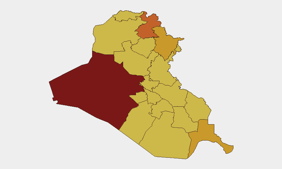
Iraq faces sustained multi-domain instability with a composite threat score of 100 (rank #11 globally) driven by coordinated aerial weapons activity, regional military posturing, and internal political friction. Over the past 48 hours, northern Iraq—particularly the Kurdistan Region—has experienced a sustained drone campaign targeting both US coalition assets and Iranian Kurdish opposition positions, with no reported casualties but significant escalation implications. Al-Anbar Governorate remains the highest-risk sub-national zone (99.9), while Erbil's spike in aerial weapons activity has elevated the broader northern tier. The security environment shows no clear de-escalation trajectory through mid-July 2026.
Key Developments
- Erbil, Kurdistan Region – July 17, 04:19–05:25 local time: Coalition air defenses intercepted and neutralized eight explosive-laden drones targeting areas near the US consulate and adjacent coalition assets; no casualties or significant infrastructure damage reported.
- Erbil & Sulaymaniyah, Kurdistan Region – July 17 (multiple incidents): US-led Coalition air defenses shot down 16 explosive-laden drones across six separate attack swarms: three targeting Iranian Kurdish opposition parties in Sulaymaniyah, and three over Erbil (including two toward the US consulate vicinity); no reported casualties.
- Erbil, Kurdistan Region – July 15 night (within 48 hours): Kurdish security authorities reported eight explosive-laden drones intercepted over Erbil near the US consulate with no civilian or security-force casualties.
- Baghdad – July 16: US Embassy in Iraq issued a security alert to American citizens nationwide, urging heightened readiness, local media monitoring, and preparation for possible travel disruptions and airspace closures due to ongoing drone activity and regional tensions.
- Erbil – July 16: Iraqi Prime Minister Ali al-Zaidi publicly condemned the drone attacks as violations of Iraqi airspace; security sources separately reported a drone targeting an Iranian Kurdish opposition camp north of Erbil.
- National – July 16–17: Composite threat assessment identifies "multi-domain instability" with ongoing aerial weapons and conventional military operations; Erbil and Al-Anbar flagged as key hotspots with sustained risk posture.
Highest-Risk Areas
Al-Anbar Governorate (99.9) anchors the national risk ranking and reflects longstanding conventional military activity and ungoverned-space exposure; this remains stable but critical. Erbil (73.9) has emerged as the acute flash point over the past 48 hours due to the coordinated drone campaign, while Sulaymaniyah (71.2) faces parallel pressure from opposition-targeting UAV swarms. The southern tier—Basra, Dhi Qar, and Maysan—maintain elevated scores (69.9–71.0) reflecting persistent crime, smuggling, and militia activity, though immediate kinetic risk remains lower than in the north. Baghdad's score (70.4) reflects capital-level political friction and dispersed sectarian tensions.
How GeoBit Would Assist
Security teams should deploy AOI (Area-of-Interest) Monitoring & Early Warning on Erbil airspace, the US consulate perimeter, and Al-Anbar supply routes to receive real-time alerts on drone activity and military movements. Intel Sweep and OSINT Fusion & Corroboration (X/Twitter, Telegram, local media feeds) provide 24-hour cross-check of emerging drone swarms and opposition statements before mainstream reporting. Conflict & Military modules enable force-structure tracking of coalition air-defense posture and Iranian-backed militia deployment patterns, supporting duty-of-care assessments for personnel movement planning.
7-Day Outlook
The drone campaign over Erbil and opposition camps appears coordinated and sustained rather than sporadic; further swarms should be expected within 7–10 days absent de-escalatory signals. US Embassy travel advisories and airspace alerts will likely remain in effect; route planning for personnel should assume potential airspace closures and extended security checkpoints in Kurdistan. Al-Anbar and southern governorates are expected to remain at baseline risk; no immediate de-escalation in northern activity is forecasted through late July.
Highest-Risk Areas — Ranked
| # | State / Region | Risk |
|---|---|---|
| 1 | Al-Anbar Governorate | 99.9 |
| 2 | Erbil Governorate | 73.9 |
| 3 | Sulaymaniyah Governorate | 71.2 |
| 4 | Al-Basra Governorate | 71 |
| 5 | Baghdad Governorate | 70.4 |
| 6 | Dhi Qar Governorate | 70.3 |
| 7 | Halabja Governorate | 70.2 |
| 8 | Babil Governorate | 69.9 |
| 9 | Wasit Governorate | 69.9 |
| 10 | Al-Qadisiyah Governorate | 69.9 |
| 11 | Al-Muthanna Governorate | 69.9 |
| 12 | Maysan Governorate | 69.9 |
Sources
Previous Daily Briefs
A new Iraq brief is written every day — each with its own risk map and downloadable CSV. Here's the last week; use the calendar to go further back.
📅 Browse every day by calendar →
Highlighted days have a brief. Tap a day for that day's map & analysis, or “csv” for that day's dataset ($5).
Atlas — our AI intelligence desk — emails them this snapshot personally. Nothing else, no list.